Home / Land, dacha, construction / Documents and legislation / Land plot / Cadastral registration / Number
Back
Published: 01/25/2018
Reading time: 4 min
0
2164
Each registered land plot is assigned a cadastral number. Knowing this number, you can quickly find the site on the Rosreestr map and get acquainted with all the information about it. However, citizens, when purchasing land, sometimes encounter the concepts of conditional and old cadastral numbers.
- Conditional number
- Old cadastral number
- Instructions: how to find out the new cadastral number of a land plot from the old one
Land Cadastre Law: innovations from January 1, 2020
The authorities continue to make changes to the legal framework aimed at streamlining relations in the land sector. Officials intend to minimize the number of illegal plots, which will have a positive impact on tax revenues
. In addition to legalizing land plots, the authorities plan to fix the existing boundaries of plots by making appropriate changes to the state cadastre.
From January 1 next year, a ban on the disposal of land plots for which the location of the boundaries has not been determined comes into force. Owners of land plots who do not survey their plots in a timely manner will be deprived of the opportunity to sell or donate their plots. At the same time, the existence of property rights will not affect the principle of operation of this norm.
. Owners of plots who registered their plots for cadastral registration before 2008 (when this procedure was not mandatory) are also required to carry out land surveying.
After successfully completing the land surveying procedure, the owner of the plot receives a cadastral extract. According to expert estimates, more than half of the plots that are on the cadastral register remain with unspecified boundaries
. This situation is also related to the simplified registration procedure established in the “dacha amnesty”.
The “dacha amnesty” mechanism was developed for simplified registration of land plots. In particular, owners who did not have a full package of title documents took advantage of the amnesty
. At the same time, land surveying during cadastral registration was optional, which will become a problem from January 1, 2020. Owners who took advantage of the simplified procedure without land surveying will have to fix the boundaries of their land plots by the end of this year.
Officials emphasize that the adopted innovations will help restore order in the land sector. The lack of land surveying leads to frequent disputes between neighbors, which have to be resolved in court. Ordinary owners of land plots who do not go through the land surveying procedure may lose their plots.
Making changes to the cadastre in 2020 | Legal Advice
Last updated March 2019
Information about a property may change over time for various reasons. It is advisable to reflect such changes in the cadastre. Otherwise, the contradictions that arise may become an obstacle to transactions and other manipulations with real estate, or greatly complicate their completion, as well as negatively affect the implementation of other rights of the owner.
For example, a citizen changed the type of permitted use of his land plot and did not make changes to the cadastre. The tax inspectorate will not recalculate the amount of land tax (including downward) until the cadastre contains information about a new type of use of the land plot.
Changes to the cadastre must be made in the following cases:
in relation to land plots when changing:
- area of the site;
- addresses or descriptions of land location;
- cadastral value;
- the appearance or disappearance of forest, water and other natural objects located on the site;
- category of land or type of permitted use;
- information about restrictions on the owner's rights.
with regards to buildings, premises, structures, when the following changes:
- main technical characteristics (area, height, number of floors, material of external walls, etc.);
- addresses or non-address descriptions of the location of the property;
- the size of the cadastral value;
- type of purpose of real estate;
- Object name;
- degree of readiness of the work in progress.
The procedure for making changes to the cadastre at the place of application and the time of the procedure is similar to the procedure for registering real estate objects on the state cadastre, but there are still differences.
Document changes to be made to the cadastre
For example, when changing the permitted use of a land plot, you must first obtain a local government act (decision, resolution, etc.) approving the new type of permitted use of the plot.
In general, each case is individual, so for the correct preparation of primary documentation, it is advisable to obtain recommendations and advice from certified realtors, lawyers, employees of local administration, BTI, Rosreestr, etc.
Receive an extract from the state cadastral chamber from the territorial cadastral chamber. cadastre
And make sure that the actual (up-to-date) information about real estate does not correspond to the information listed in the cadastre.
Who has the right to apply to the cadastre to make changes
Only the owner or his representative can address such a question with a notarized power of attorney (the power of attorney must include information that the representative has the right to submit applications for changes to the cadastre).
However there are exceptions:
- any person regarding:
- information about the address or description of the location of the object;
- land categories.
- state-owned companies regarding information on the amount of cadastral value.
Where to contact
The property owner may apply at his own discretion:
- to the territorial cadastral chamber;
- MFC branch.
There are three ways to contact these organizations:
- appear in person;
- send documents by mail;
- send a package of documents over the Internet through the website of state and municipal services.
The most reliable way is to appear directly, since:
- it is cost-effective (when sent by mail, all documents must be certified by a notary, plus postal services);
- there is feedback (you can get clarification and advice from a specialist on the essence of the issue, and if there are any errors that could lead to refusal, they can be eliminated on the spot, which will save time and nerves);
- no additional technical means are required (when applying via the Internet you need to have an electronic signature, etc.).
Therefore, in the future, when speaking about the procedure for making changes to the cadastre, we will mean submitting documents directly to the cadastral authority or MFC.
What documents need to be provided
1. Statement of the established form. The application form can be obtained from the cadastral office. There, a specialist will provide assistance in filling it out. In addition, the application form is available on the Rosreestr website in the “cadastral activities” section.
The application is filled out in one copy and signed by the applicant (his representative) in the presence of an employee of the cadastral chamber or an employee of the MFC.
It is advisable to indicate a valid telephone number in the application so that if problems arise, a cadastre employee can contact you and promptly resolve the difficult situation.
2. Citizen's passport. If the documents are submitted by a representative, then also a notarized power of attorney. The passport and power of attorney must be submitted in original and a copy. The original is only presented; copies remain on file with the cadastral officer.
3. Documents confirming ownership of the object about which changes are made. This is usually a certificate of ownership.
If there is no such document or it is outdated, as well as in other similar situations, the basis documents (purchase agreement, commissioning certificate, technical passport, etc.) are submitted to the cadastre.
The official is presented with the original (with a return), and copies of such documents remain on file.
4. A document that contains information about changes. The type of documents varies depending on the specific life case. The main situations are as follows:
- Boundary plan (for land plots). Such a plan contains new (clarified, changed, etc.) information about the site (location of boundaries, area, etc.);
- Technical plan (regarding buildings and premises). This plan indicates typical data with updated parameters (number of floors, area, material of external walls, etc.). Although the old technical plan remains in effect, the new one has legal force.
- Transfer of land - decisions of authorized bodies of local self-government or state. authorities on the transfer of land from one category to another (when the categorization of a land plot changes);
- Resolution of municipal or federal authorities on the assignment of a new type of use of a land plot (if such a type was not previously provided), a certificate from the architecture department of the administration about the existing types of permitted use (in the event of a change from one type of use to another from among the already existing (permitted));
- Purpose of the building – documents of a municipal or state agency on changing the purpose of the building or premises. These are mainly decisions of local administrations;
- Change of address - a decision, resolution of a municipal body on the assignment or change of address (if the changes concern the location of the land plot and buildings);
- other.
This category of documents is presented in copies with originals to certify the accuracy of the documents.
When applying to change information in the cadastre, state duty and other payments are not paid.
On acceptance of documents, the cadastre or MFC employee issues a receipt to the applicant, which indicates the date of acceptance of the documents, their list and the date of appearance at the cadastre (MFC) after the changes have been made.
Deadlines
The period for changes in the cadastre after submission of documents is no more than 18 calendar days. If the application is made through the MFC, then no more than 21 days.
Appear to receive
By the deadline specified in the receipt, you must appear at the cadastral chamber or MFC (depending on where the documents were submitted) and, upon presentation of your passport, receive a cadastral passport, which will take into account all the required changes. From this moment the procedure is considered completed.
However, it is possible to refuse to change the information in the cadastre. What is a reasoned decision about? Such a decision can be challenged, but it is better to take into account his comments and resubmit the documents. The following reasons may serve as grounds for refusal:
- an unauthorized person applied to change information in the cadastre (not the owner or the powers of the representative were incorrectly formalized);
- in order to change the cadastre, the applicant has not submitted the necessary documents, or the documents contain gross inaccuracies and errors;
- As a result of the changes made, violations of the legislation of the Russian Federation may occur.
Contact the registration service of Rosreestr
Changes in the cadastre are only half the battle. With a new cadastral passport, you then need to contact the registration service of Rosreestr to make adjustments to the state register. register of real estate and transactions with it. To do this, submit to the registration:
- application of the established form on changing the information in the state. registry;
- one copy of the cadastral passport in the original and a copy;
- documents confirming ownership of the object;
- state duty (for individuals -200 rubles, for legal entities -600 rubles). The fee can be paid through terminals at the Rosreestr premises;
- the applicant’s passport (if the documents are submitted by a representative, then also a notarized power of attorney).
To submit documents, you can contact both the territorial registration department and the MFC. This can be done either directly or by mail, or through the state services website. Registration time is 5-10 working days.
Subtleties
It is necessary to distinguish changes in the cadastre from registration after the termination of registration of real estate and from the correction of errors.
Regarding the simultaneous deregistration and new registration, it should be noted that, as a rule, such situations arise during the global redistribution of real estate or when several objects are involved in the process. When making the necessary changes to the cadastre, only minor alterations occur.
For example, if as a result of the reconstruction of a building the area has increased by 10 sq.m., then of course this is a change in the cadastre.
If an extension to the building was erected, requiring separate commissioning, then the original building is removed from the cadastral register and the entire complex is staged at once (the older ones are the rear ones, plus the extension, as a single object).
Regarding the correction of errors, this is a special procedure provided for by law. Correction of errors is carried out either at the initiative of the cadastral authority, or at the request of any person, or by court decision. In any case, the authorized body makes a decision about the identified error and eliminates the error within five days, of which interested parties are notified.
Ordinartsev Roman Valerievich
Source: https://juresovet.ru/kak-vnesti-izmenenie-v-gosudarstvennyj-kadastr-2/
Consequences for site owners
Failure to survey or register a plot of land in the Unified State Register may be grounds for loss of property rights. The court may recognize such a land plot as “no man’s”
. In this case, local authorities will be able to dispose of the site.
After the corresponding court decision, the “former” owner of the land plot will not be able to sell, exchange or donate his plot. Also, ownership of such a plot cannot be inherited.
In addition to mandatory land surveying starting in 2020, land owners need to take into account other changes in the cadastre that will remain relevant next year. First of all, this concerns the assessment of sites on the basis of which the amount of tax will be calculated.
Next year, government agencies will assess the sites. At the same time, the cost of the plot will be as close as possible to the market price, officials emphasize. Previously, the assessment of plots could be carried out by contract workers who represented an independent party
.
Representatives of the government apparatus will be interested in the maximum assessment of the site, experts emphasize
.
In some cases, ordinary owners will have to defend their interests in court
. Otherwise, taxes will be calculated on the value recorded in the state cadastre.
The transition to cadastral value will lead to an increase in budget revenues. The economic crisis and falling oil prices have led to a sharp increase in the budget deficit
. Among other things, the budgets of the regions, which depended on the amount of tax revenues, were under attack.
When determining the cadastral valuation, various factors are taken into account that help to get as close as possible to the market value. Regions retain the right to use a differentiated approach when determining the tax rate
. As a result, local authorities received a tool that allows them to increase budget revenues.
Starting next year, owners of land plots will face further innovations that may limit the rights of owners. Problems await owners who do not timely record the boundaries of their plots in the land cadastre
. In this case, the court may recognize the land as “no man’s land,” and the ex-owner will lose the right to dispose of his plot.
The transition to cadastral value will have a positive impact on local budget revenues. In 2020, cadastral valuation will be carried out exclusively by government agencies
. If the owner of a land plot considers the cadastral value to be inflated, then he will have to challenge the assessment in court.
Watch the video about mandatory land surveying until 2020:
Does the cadastral number change when the owner changes?
If you do not add new information to the register, the data will not be current.
For example, changes need to be made if one plot is divided into two. In this case, these are already two independent objects, with their own address, area and boundaries. However, if the owner changes, the cadastral number remains the same.
Adjustments are made on the basis of an application in a special form. It consists of five sheets into which the necessary data is entered.
The application must provide information about the owner, the property and the reason for the changes. It is also necessary to leave contact information for sending notifications about the progress of the application.
We recommend reading:
If the property was sold or transferred to another person on other grounds, this information is entered into the Rosreestr. Only the data in the Unified Register (USRN) itself will change, but the cadastral number remains the same. Advertising unit: The identification code is adjusted only if the property is reduced, enlarged, changed address or destroyed.
In these cases, objects are given a new number and the old one is destroyed.
When there is a change of owner, the new owner contacts Rosreestr to correct the documents.
Now his data should be listed everywhere, and information about the previous owner is transferred to the archive.
Finding out who the owner of a particular real estate property is is quite simple. Any interested person can do this. We'll tell you how to get the information you need.
To obtain information about the owner of the property, you must contact Rosreestr where the property is located. The data is provided on the basis of the following documents:
- statements indicating the reason for the appeal;
- receipt of payment of state duty.
- general civil passport of the Russian Federation;
The state fee is 300 rubles for individuals and 950 rubles for organizations. An extract with the necessary information is prepared within three days.
To obtain an extract from the Unified State Register of Real Estate
What is it and what does it mean?
In Soviet times, there was no need to officially register your real estate in the cadastral register, since any real estate objects were owned by the state.
Today, using a unique real estate identification number, any citizen can, if necessary, confirm that he has ownership rights to a land plot.
In this regard, determining the cadastral number may be required:
- when purchasing or selling real estate;
- when registering the right of inheritance or donation;
- to prove your own property rights in court in the process of conflict situations;
- in order to rent out real estate.
Thus, the cadastral number is the most important point when conducting any transactions with real estate, and without assigning the specified number, transactions with such property become impossible in principle.
The resulting cadastral passport, which is issued after receiving all the documents, includes quite extensive information about the land plot in question. For example, there is information here about who is the owner of the land plot, what area the specified territory has, what number it is assigned and
cadastral value
.
If for any reason a person does not agree with the results of the cadastral assessment, he can always contact government authorities to change it, but for this he will need to collect other documents.
The received passport is the main document issued for the land plot, since it confirms the ownership of the territory of a certain citizen, and also ensures the identification of real estate.
If any conflict situations arise, it is this certificate that will make it possible to determine the ownership of a particular citizen.
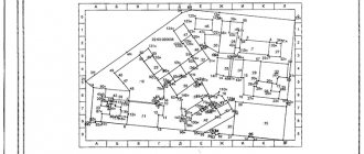
Sample cadastral passport of a land plot
Does the cadastral number change when the owner changes?
Given this fact, within two years from the date of registration it is necessary to register the rights to this land plot. If this does not happen, the body responsible for cadastral registration, acting on the basis of the Law “On the State Real Estate Cadastre”, which was adopted on July 24, 2007 under No. 221-FZ, undertakes to cancel information about such a plot. In other words, if you have any rights to a land plot (for example, you use it as a lease), and it was registered with the cadastral service later than 03/01/2008, but you have not carried out state registration of the right to this plot of land in the appropriate body, which is the Office of the Federal State Registration Service, then information about your site will be canceled after 2 years.
Important!!! If you do not know the exact date of registration, it is very easy to find out. This information is indicated in the cadastral passport: in paragraph No. 6 on the first sheet of the document. You need to understand that parts of the land plot can also undergo the cancellation procedure.
Information about parts of a real estate property may be excluded from the state cadastre after one year from the day the parts of the property were registered. If information about parts of a plot of land undergoes the cancellation procedure, this does not mean that information about the plot itself will be deleted. They will be kept up to date in the real estate cadastre.
As a result of the cancellation of a part, the existence of the plot of land as a whole cannot be disputed. Also, its characteristics do not change, including its area.
An allotment whose entry has been deleted from the state real estate register is considered unaccounted for.
And here a problem arises with the registration of proprietary rights to such property, since it is impossible to register rights to real estate that is not included in the state register of real estate. If, on a plot of land that has a temporary status, there is a judicial act that contains the necessary instructions, then the validity period of all data entered in the state register can be suspended for a time, terminated or extended.
What to do if land claims are cancelled? It's simple.
Why do you need to change
The conditions under which it may be necessary to make adjustments to the cadastral number or completely cancel this parameter are prescribed in Federal Law No. 221, which was adopted in 2007.
Thus, amendments are made to the state register only in exceptional situations, that is, when any changes occur related to the land plot itself, or when the territory is endowed with new properties.
At the same time, a change of owner cannot be considered as a basis for changing the cadastral number, because the key properties of the land plot continue to remain unchanged.
Some modifications of the characteristics of a land plot require submitting an appropriate application to Rosreestr to make changes to the state cadastre, but as a result of the operation the cadastral number will not change. In particular, this applies to the construction of new buildings on the territory of a land plot or changes in its cadastral price.
Does the cadastral number change when the owner changes?
A cadastral number is a characteristic of a property by which you can find out all the necessary information about it, including about the owner.
It is assigned at the time of registration. The data assigned to the cadastral number must be current. Further in the article the procedure for changing ownership and how this affects the cadastral number will be discussed.
Contents The cadastral number is assigned according to the procedure prescribed in Federal Law No. 218 “On State Registration of Objects” and in Federal Law No. 221 “On Cadastral Activities”.
The procedure for recording and registering cadastral numbers is carried out by employees of Rosreestr or the territorial MFC. In the second case, the registration process may be delayed. If a property needs to be liquidated, its cadastral number is canceled. Information about this is entered into Rosreestr.
If some of the characteristics of the house (for example, its area, number of floors, etc.) change, then the cadastral number also needs to be changed. To make appropriate amendments to Rosreestr data, you must fill out an application using a special form.
This document will consist of 5 sheets, which will indicate information about the owner, the property and the reasons for the changes.
The application also specifies contacts to which notifications about the progress of its consideration can be sent.
If the property has been sold or transferred to a new owner, such data must be recorded in Rosreestr.
In this case, the information in the USRN extract will change, but the cadastral number will not change. If not only the owner of the house has changed, but also the visual characteristics of the property (it was divided into two parts, floors were added, etc.), the cadastral number will be changed. Information about the new owner of the property must be written down in all documents that relate to it.
This can be done by Rosreestr employees, to whom you must submit an appropriate appeal.
To obtain information about the owner of a property, you must submit a corresponding request to Rosreestr. To do this you need to present the following documents:
- a receipt for payment of the state fee (300 rubles for individuals and 950 for legal entities);
- passport of a citizen of the Russian Federation;
- statements indicating the reasons for the appeal.
An extract with data will be prepared within 3 days after the application.
You can submit such an application in different ways:
- independently come to the authorities of the MFC or Rosreestr;
- submit an application on the institution's website.
There are cases in which the applicant may be refused a response to the relevant request. If he filled out the application incorrectly, did not pay the state fee, or presented incorrect documents, it will not be possible to find out information about the owner of the object. In some situations, the requested data may simply not be in the system.
The refusal must be submitted in writing with reasons for such a decision. The applicant has the opportunity to correct the comments and apply again. If there were no grounds for refusal, such a decision can be appealed in court.
FacebookTwitterVKontakteGoogle+
How does the cadastral number of a land plot change?
Today, state registration of real estate is carried out by authorized employees of Rosreestr, and therefore, in order to make adjustments to the cadastral number of a land plot, you need to contact the territorial office of this body located at the location of the plot of interest.
To clarify the address of regional offices, you can go to the official website of the specified department. Also, if necessary, all necessary documents can be submitted to the multifunctional center or online on the official website of the department.
The documents that will need to be provided to make adjustments to the state register are as follows:
- the applicant's civil passport;
- an extract made from the state register;
- completed cadastral passport and boundary plan;
- a decision made by a territorial administrative body to change the address of the specified real estate, transfer a land plot to another category, or carry out any other actions due to which there is a need to change the cadastral number;
- technical plan drawn up for any real estate located within the land plot.
Regardless of the circumstances, the owner will be required to fill out an application form, on the basis of which adjustments will be made. This document can be filled out when visiting Rosreestr or in advance.
The provision of the public service itself is absolutely free, and payment of the state fee is provided only if the property owner needs to obtain a new extract from the state register.
The procedure for changing the number followed by making amendments to the state register must be carried out within 18 days, but if the application is submitted by mail or through a multifunctional center, the period may increase by the time required to deliver the notification through the postal service or using a multifunctional courier center, and will be from 21 to 25 days.
Land owners can constantly monitor the processing status of the submitted application online using the received number.
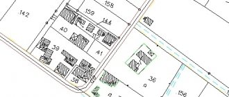
Sample boundary plan:
Where to contact
As mentioned above, applications are considered at the territorial office of Rosreestr or through a multifunctional center. The latter body is a simple intermediary between government agencies and ordinary citizens, and its employees are not involved in reviewing submitted documents or making any decisions.
In this regard, contacting this body is carried out only if it is more convenient than submitting a full package of papers to the territorial office of Rosreestr, since the procedure for processing documents through the MFC will take longer.
Cost of the procedure
In addition to all the necessary operations, the interested person will have to pay the state fee provided for by current legislation. The amount of this fee will vary depending on who is applying for a government service and why it is needed in general.
Thus, legal entities pay a state fee of 1,000 rubles, while individuals may be limited to a fee of 100 rubles.
At the same time, the electronic version of the passport provides for an additional payment of 50 or 300 rubles for individuals and legal entities, respectively. If the interested person orders the specified document in paper form, its cost will already be 200 and 600 rubles for individuals and legal entities, respectively.
Does the cadastral number change when the owner changes?
For example, changes need to be made if one plot is divided into two. In this case, these are already two independent objects, with their own address, area and boundaries.
However, if the owner changes, the cadastral number remains the same.
Adjustments are made on the basis of an application in a special form.
It consists of five sheets into which the necessary data is entered. The application must provide information about the owner, the property and the reason for the changes. It is also necessary to leave contact information for sending notifications about the progress of the application.
If the property was sold or transferred to another person on other grounds, this information is entered into the Rosreestr. Only the data in the Unified Register (USRN) itself will change, but the cadastral number remains the same.
Advertising unit: The identification code is adjusted only if the property is reduced, enlarged, changed address or destroyed.
In these cases, objects are given a new number and the old one is destroyed.
When there is a change of owner, the new owner contacts Rosreestr to correct the documents. Now his data should be listed everywhere, and information about the previous owner is transferred to the archive. Finding out who the owner of a particular real estate property is is quite simple.
Any interested person can do this.
The data is provided on the basis of the following documents:
- receipt of payment of state duty.
- general civil passport of the Russian Federation;
- statements indicating the reason for the appeal;
The state fee is 300 rubles for individuals and 950 rubles for organizations.
We'll tell you how to get the information you need. To obtain information about the owner of the property, you must contact Rosreestr where the property is located.
What to do if Rosreestr independently assigned a different code to the plot
Correction of such technical errors is carried out in accordance with Article 28 of Federal Law No. 221, adopted on July 24, 2007. As a result of making appropriate adjustments to the information specified in the state cadastre, in the future, data on the previously recorded site will be transferred to the correct cadastral quarter.
These standards are spelled out in Rosreestr letter No. 14-9519-VK, which was published on November 17, 2009.
A cadastral number is assigned to each land plot included in the state real estate register (USRN). It allows you to clearly identify the land plot
. Typically, a number is assigned to a site at a time and cannot be changed. But sometimes situations arise that require owners to take active action to change the current cadastral number.
What is a cadastral apartment number and when is it assigned?
Information from the register may be required by the owner himself or by third parties, which is quite understandable when a real estate transaction is pending. When a cadastral number is assigned to an apartment, this is done by the registrar forever. There may be significant changes that are interesting and have a significant impact on future actions. The registrar monitors the timely correction of data, but sometimes the human factor leads to failures.
You can use the official cadastral map, which is open to access. There you can see the surrounding structures and other signs of the area around the object of interest to you. The cadastral value of the apartment is important, which will soon be taken into account when collecting the annual property tax.
We recommend reading: Benefits for the birth of a second child in 2020 in Novosibirsk
How to change the cadastral number?
Rosreestr maintains state records of real estate in Russia. This is where you need to go to make changes.
.
The application is submitted to the territorial office of Rosreestr at the location of the land plot
.
You can find out the addresses of regional offices and authorized branches for accepting applications directly on the department’s website.
If you want to find out how to solve your particular problem, call the following numbers: Moscow +7(499)350-66-30 , St. Petersburg +7(812)309-36-67 .
Other ways to make changes is to transfer documents through the MFC or by Russian post. Rosreestr also allows you to send an application in electronic format through the website.
The documents required from the applicant to amend the State Tax Code will depend on the specific situation. This list may include:
- Applicant's passport and power of attorney to represent interests (optional).
- An extract from the Unified State Register of Real Estate (it must, among other things, confirm the ownership rights to the applicant’s land).
- Boundary plan and cadastral passport.
- The administration’s decision to change the address, transfer land, clarify their intended use.
- Technical plan for the located buildings.
In any case, the owner will be required to fill out an application form for making changes. It can be filled out directly during a visit to Rosreestr or in advance. The application must include:
- name of the Rosreestr body;
- the reason that prompted the owner to make changes (what characteristics of the site have changed);
- information about the applicant;
- list of attached documents;
- consent to the processing of personal data;
- preferred method of receiving a decision on the application (in person, by mail or through a representative).
statements you can
Here
.
The edits themselves are made free of charge. The state duty is paid only if the owner needs to obtain a new extract from the Unified State Register of Real Estate.
The department will have 18 days to change the number and make amendments to the State Tax Code. But when submitting an application by mail or through the MFC, the specified deadlines can be extended by the time the notification is delivered by the postal service or MFC couriers up to 21-25 days
. Land owners will always be able to track the status of application processing online using the number issued to them.
During the specified time frame, the owner may be refused to register changes (for example, if factual errors and inaccuracies are found, or documents are incomplete).
Does the cadastral number change when the owner changes?
For example, changes need to be made if one plot is divided into two. In this case, these are already two independent objects, with their own address, area and boundaries. However, if the owner changes, the cadastral number remains the same. Adjustments are made on the basis of an application in a special form.
It consists of five sheets into which the necessary data is entered.
The application must provide information about the owner, the property and the reason for the changes. It is also necessary to leave contact information for sending notifications about the progress of the application. If the property was sold or transferred to another person on other grounds, this information is entered into the Rosreestr.
Only the data in the Unified Register (USRN) itself will change, but the cadastral number remains the same. Dear readers! We cover standard methods for solving legal problems, but your case may be unique. We will help you find a solution to your problem for free - just call our legal consultant by phone: +7 (St. Petersburg) It's fast and free!
You can also quickly get an answer through the consultant form on the website.
The identification code is only adjusted if the property is downsized, enlarged, changed address or destroyed. In these cases, objects are given a new number and the old one is destroyed. When there is a change of owner, the new owner contacts Rosreestr to correct the documents.
Now his data should be listed everywhere, and information about the previous owner is transferred to the archive. Finding out who the owner of a particular real estate property is is quite simple.
Any interested person can do this.
We'll tell you how to get the information you need. To obtain information about the owner of the property, you must contact Rosreestr where the property is located.
The data is provided on the basis of the following documents: an application indicating the reason for the application; general civil passport of the Russian Federation;
How is a cadastral number canceled?
In a situation where the owner becomes aware of the cancellation of information about a land plot and its exclusion from the State Property Committee, he needs to take measures to register the plot with Rosreestr. Only in this way will he be able to legitimize his rights to the land.
This procedure involves going through the following steps:
- Collection of the necessary set of documents. The list of required documentation includes: the applicant’s passport; boundary plan drawn up by a cadastral engineer; application for registration of the site. The specified list of documents is not exhaustive and can be supplemented taking into account the specific changes.
- With the presented set of documents, you must contact the Rosreestr branch, the MFC (pre-registration for an appointment is allowed) or send them electronically using the government services portal. This service is provided free of charge.
- Receive an extract from the Unified State Register of Real Estate, confirming the assignment of a cadastral number and the introduction of changes to the State Tax Registration Number.
Thus, when canceling the cadastral number, the user must re-register the land, since there is no possibility of restoring information from the State Property Committee.
Dear readers, the information in the article may be out of date, take advantage of a free consultation by calling: Moscow +7(499)350-66-30 , St. Petersburg +7(812)309-36-67 .
In recent months, one could see how many cadastral engineers almost unanimously argued that if the land plot is not surveyed before January 1, 2020, then the owner of the property right will lose the right to use his own land plot. Rosreestr had to urgently reassure citizens and give some explanations why this excitement arose.
Does the cadastral number change when the owner changes?
Is this possible?
An extract with the necessary information is prepared within three days. To obtain an extract from the Unified State Register of Real Estate by cadastral number, you can contact Rosreestr or the MFC in person, or send an application online on the official website of the institution.
The certificate was received in 2002. Thank you Real Estate and Land | Bryansk Complain to moderator Answers from lawyers Alexey Vladimirovich (03/25/2016 at 09:14:12 pm) Hello, Cadastral number (or conditional number) is assigned to the object, not to the owner. Therefore it must be the same. Info Since 2012, the Federal Service for State Registration, Cadastre and Cartography (Rosreestr) has been carrying out, together with the Cadastral Chamber, activities to compare data from the state real estate cadastre (GKN) and the unified state register of rights to real estate and transactions with it (USRP).
In the Unified State Register, the replacement of the cadastral or conditional number was carried out in an automated mode, however, due to discrepancies in characteristics, for example, the area of the object, many objects turned out to be unmatched.
Their comparison, as well as the harmonization of characteristics, is carried out within the framework of the activities of these services.
To check data on real estate objects, it is recommended to use Reference information on real estate objects online on the Rosreestr portal https://rosreestr.ru/wps/portal/online_request. The search can be done by cadastral number or by address. The number is tied to a plot of land. The numbers indicate the cadastral quarter + the serial number of the plot within the quarter (this is the last group of digits in the number). The number changes when the boundaries of the plot change (if the newly formed plot remains within the boundaries of the existing cadastral quarter, then the last group of numbers in the cadastral quarter will change number).https://kadastr.tatarstan.ru/rus/kadastrovii_nomer.htm Bonk 13-11-2013 18:33 quote: Originally posted by Rus_16:...the last group of digits in the cadastral number will change).https://kadastr. tatarstan.ru/rus/kadastrovii_nomer.htm When the owner of a plot of land changes, does the last group of digits in the cadastral number change?
Where can I see cadastral numbers reflecting all previous owners?
Diego03 13-11-2013 21:52 quote: Originally posted
Everything remains the same, but you need to be vigilant
First of all, Rosreestr explained that land surveying from January 1, 2020 will be carried out on a voluntary basis, as before, and no one will take away a land plot, even if you did not have time to go through this procedure before December 31, 2020. The second sign of excitement was most likely caused by the fact that cadastral engineers decided to interpret the law on land plots and the new law on cadastral real estate in their own way. The third sign is banal greed; cadastral engineers still wanted to make money from the legal illiteracy of the population.
Land surveying from January 1, 2020
Further, Rosreestr says that the new Federal Law-18 does not indicate anywhere about the timing of land surveying, which means that everything remains as before, but still, there is a certain recommendation on what needs to be done with the land plot after this period. An official representative of Rosreestr even pointed out the fact that Rosreestr does not speak anywhere on the website or in public statements about mandatory land surveying.
If your extract contains no information about actual land surveying, then you can easily go through this procedure after January 1, 2020, and the state will not apply sanctions to land owners.
Does the cadastral number change when the owner changes?
For example, changes need to be made if one plot is divided into two.
In this case, these are already two independent objects, with their own address, area and boundaries. However, if the owner changes, the cadastral number remains the same.
Adjustments are made on the basis of an application in a special form.
It consists of five sheets into which the necessary data is entered. The application must provide information about the owner, the property and the reason for the changes.
It is also necessary to leave contact information for sending notifications about the progress of the application.
If the property was sold or transferred to another person on other grounds, this information is entered into the Rosreestr.
Only the data in the Unified Register (USRN) itself will change, but the cadastral number remains the same. Advertising unit: The identification code is adjusted only if the property is reduced, enlarged, changed address or destroyed.
In these cases, objects are given a new number and the old one is destroyed.
When there is a change of owner, the new owner contacts Rosreestr to correct the documents. Now his data should be listed everywhere, and information about the previous owner is transferred to the archive. Finding out who the owner of a particular real estate property is is quite simple.
Any interested person can do this. We'll tell you how to get the information you need. To obtain information about the owner of the property, you must contact Rosreestr where the property is located.
The data is provided on the basis of the following documents:
- general civil passport of the Russian Federation;
- statements indicating the reason for the appeal;
- receipt of payment of state duty.
The state fee is 300 rubles for individuals and 950 rubles for organizations. An extract with the necessary information is prepared within three days.
To obtain an extract from the Unified State Register of Real Estate by cadastral number, you can contact Rosreestr or the MFC in person, or send an application online on the official website of the institution.
Where did the rumors about urgent land survey come from?
Meanwhile, there remain a number of factors under which land surveying will still need to be carried out without fail from 2020, regardless of the actual status of the land:
- You have a dispute with your neighbors or the state is making claims on a plot of land.
- During the sale without land survey, one of the parties made a claim to the land plot.
Figuratively speaking, land surveying is necessary if there is some kind of dispute with one of the parties. In addition, you can sell your plot of land next year without surveying, but the lack of surveying can play a cruel joke on the new owner due to the fact that someone will make a claim
.
Therefore, Rosreestr gives only RECOMMENDATIONS for carrying out land surveying on a voluntary basis
. Thus, you will fix the coordinate points of the object of law for all occasions.
Land surveying in 2020
Does the cadastral number change when the owner changes?
All information provided is public and the provision of information on the subject of law is regulated by the current legislation of the country.
When issuing an extract from the Unified State Register, the cost of the service is charged, taking into account the state fee. Information about the owners is not shown on the Rosreestr website, because information about the owners is in the Unified State Register of Real Estate, but only reference information about real estate is uploaded to the public on the Rosreestr website.
The names of the owners are not included in the reference information. The owners are shown in the extract from the Unified State Register.
You can see for yourself: 1) On this page of Rosreestr, enter the cadastral number of the plot or address.
Examples of addresses , , . 2) At the bottom, enter and click on “Create a request”. 3) On the page that opens, click on the site address.
4) The page shows reference information from the Unified State Register of Real Estate. As I wrote above, the owners are not shown. As an example, I chose a site at the address: subject: Samara region, district: Samara, street: Selectionnaya, building: 15.
Its cadastral number is 63:01:0252002:652. Here's what. As you can see, there are no owners.
Also, information about copyright holders does not need to be searched in various databases on the Internet; it is out of date and contains viruses - I checked it myself. Do not contact the Housing Office, lawyers, or notaries, because... they don't share that kind of information.
I will not list the information that is in the extract; it’s better to look at the sample below. In section No. 2 in item No. 1 “Copyright holder” the owner of the site is shown (the full name in the sample has been painted over, because
I have no right to “shine” such things without permission). (click on the sample to enlarge it) Official name -
“extract from the Unified State Register of Real Estate on the main characteristics and registered rights to the property”
. In our case, a real estate object is a land plot.
Extracts from the Unified State Register are available in electronic and paper form. The electronic version is great for finding out who the owner of the land is. Any person (not even a citizen of the Russian Federation) can order an extract for any real estate in the Russian Federation.
Who does land surveying
The land surveying procedure is within the competence of cadastral managers. You can find the “Cadastral Register Engineer” section on the Rosreestr website, where you can select a suitable specialist from the list. In the register you can study the specialist’s data, as well as read reviews about him.
Stages of land surveying
The surveying procedure itself includes the following:
- Establishment and precise determination of coordinate points of the land plot.
- Attaching boundary markers to the site.
- Accurate determination of the area of land.
- Formation of a refined boundary plan, as well as completion of a topographic drawing, including based on aerial photography data.
- Entering data into the Roskadastre database.
This is the basic procedure for carrying out boundary work.
Stages of land surveying in 2020
How can an owner go through the stages of land surveying correctly?
The survey period may take up to 2 months; this is the maximum period determined by the cadastre law in the Russian Federation. In any case, during the land surveying process various changes in configuration and changes may occur. Coordinate points, by rotation angles
. Ultimately, you will officially secure your data in the Rosreestr database, and no one will be able to encroach on your land plot.
The land surveying stages themselves take place according to a specially approved scheme:
- We prepare the required package of documents in 2 copies for the geodetic service.
- An act is being developed to determine the coordinate points of the land plot, the signatures of the land owner, neighbors, government representatives, as well as the specialist who is conducting the work are signed.
- We receive one of the copies from the official master plan form.
- We present a document confirming the absence of arrest (in some cases this is not required, you need to check with a specialist).
- Carrying out geodetic survey of the area.
- Installation of boundary signs (special symbols in the form of flags or other identification marks).
- Drawing up a boundary plan that is submitted to Rosreestr.
- Receiving a new extract from the Unified State Register of Real Estate, indicating the new coordinate points of the land allotment.
Thus, you legally secure the right to the boundaries of a plot of land, and in the future you can dispose of your property at your discretion.
Remember that land surveying is voluntary, but if you don’t want problems in the future, we recommend that you do not put the matter off, but order land surveying from a specialist who will carry out the work in accordance with the requirements of Russian cadastral legislation.
Does the cadastral number change when the owner changes?
For example, changes need to be made if one plot is divided into two.
In this case, these are already two independent objects, with their own address, area and boundaries.
However, if the owner changes, the cadastral number remains the same. Adjustments are made on the basis of an application in a special form. It consists of five sheets into which the necessary data is entered.
The application must provide information about the owner, the property and the reason for the changes. It is also necessary to leave contact information for sending notifications about the progress of consideration of the application. If the property was sold or transferred to another person on other grounds, this information is entered into the Rosreestr. Only the data in the Unified Register (USRN) itself will change, but the cadastral number remains the same. The identification code is adjusted only if the property is reduced, enlarged, changed address or destroyed.
In these cases, the objects are given a new number, and the old one is destroyed. When the owner changes, the new owner contacts Rosreestr to correct the documents. Now his data should be listed everywhere, and information about the previous owner is transferred to the archive. Finding out who the owner of a particular real estate is is quite simple. Any interested person can do this.
We will tell you how to get the necessary information. To obtain information about the owner of the property, you must contact Rosreestr, where the property is located. The data is provided on the basis of the following documents:
- statements indicating the reason for the appeal;
- general civil passport of the Russian Federation;
- receipt of payment of state duty.
The state fee is 300 rubles for individuals and 950 rubles for organizations.
An extract with the necessary information is prepared within three days. To obtain an extract from the Unified State Register of Real Estate by cadastral number, you can contact Rosreestr or the MFC in person, or also send an application online on the official website of the institution.