All articles
4426
2020-03-14
In order to find out the cadastral number of a land plot in 2020, you need to enter the address of the property the “search bar”
The owner of a land asset may be faced with the need to find out the cadastral number
. To become the owner of a plot with a fixed boundary, you need to go through a registration procedure regulated by law.
Once registered, the asset is assigned a code, called a cadastral number in legal parlance. The cadastral number consists of numbers that are not repeated in other entities; it is unique and individual.
How to find out the cadastral number of a land plot
– contact the registration authority or find out
online
Rosreestr The code entered into a special register protects the land plot from illegal manipulation and allows the state to keep records of all land assets.
Find out the cadastral number of the land plot
needed by all subjects.
This provides a legal basis for disposing of an asset, certifying the right to land, and making transactions.
After we have found out the cadastral number of the land, an extract from the Unified State Register , displaying all the information, data, and characteristics.
Where is the data stored?
In order to understand how you can find out the cadastral number of a land plot, you need to understand where the data is stored. They are stored in the State Real Estate Cadastre.
The law states that each land plot must have a number; for this, the land plot is entered into the state database.
Repetitions are excluded both in numbers and in time and territorial data. In Rosreestr, land assets are divided into blocks, districts, and districts. All changes are immediately recorded.
How to find out the cadastral number of a plot by address
Find out the cadastral number by the property address
You can use the Internet or personally contact the registration authority.
Subjects can use one of the following methods:
- Cadastral map . The thematic map displays in graphic format the data of all land plots included in the State Real Estate Cadastre. It is important to use a cadastral map when you have an idea of where the plot is located, when you have practical skills and theoretical knowledge of how to properly organize the work. To obtain information, you need to find a land asset on the map and click on it.
- Rosreestr. You can find out the cadastral number at the address through Rosreestr
. To do this, you need to perform a number of actions, the answer will arrive within a few days. - Personal appeal. It is not possible to go to the registration authority’s website; contact the department or the MFC in person. The owner of the plot must have an identification document with him and information about the location of the land plot.
The presented methods allow you to obtain standard or extended information. To obtain expanded information, you need to request an extract from the Unified State Register of Real Estate. The extract displays information about the land asset, the owner, the status of the land (there are restrictions, arrests imposed or not).
When dealing with the question of where to find out the cadastral number of a land plot
, most subjects request an extended form to obtain detailed information.
Receipt procedure
Documentation
To obtain a cadastral number, you first need to prepare the necessary documents :
- a certificate confirming land ownership or an extract from the Unified State Register of Real Estate;
- a document that is the basis for acquiring the right to use real estate (this can be a purchase and sale or lease agreement, a certificate of inheritance, a deed of gift);
- if the land ownership is located on the territory of a gardening association, a certificate of membership in this association will be required;
- if you need to rent an object from the state or municipality, you must obtain the written consent of the municipality and other tenants, if any;
- when one of the owners is a minor, it may be necessary to obtain the consent of the guardianship authority;
- a duly certified certificate of assignment of an identification code;
- technical plan;
- boundary plan;
- identification document of the interested citizen (civil passport.
The technical plan and the surveying procedure can be ordered from a geodetic company , making sure that such work is permitted by its license.
In certain situations, the owner of the land does not have the opportunity to act personally for himself. In such cases, according to the described procedure, a representative may act on his behalf, for whom it is necessary to issue a power of attorney certified by a notary.
Read more: New law on inheriting an apartment by will
Where is it issued?
A cadastral number can be obtained by submitting a package of documents to the local branch of Rosreestr or to the MFC .
A prerequisite is preliminary land surveying; to carry out this procedure, you will need to contact a geodetic company.
An agency official will ask the applicant to complete an application, also called a request.
Then the citizen must be given a receipt for payment of the state duty. Its size today is 200 rubles .
An employee of the institution takes the documents, in return for which he gives the applicant a receipt. It must contain a list of all transferred papers, as well as the date when you can pick up the extract with the cadastral number. If you submit an application through the MFC, you can receive the finished document there.
Starting from 2020, cadastral passports are no longer issued as they have been abolished. Now the applicant is given a single extract from Rosreestr.
Deadlines for preparing an extract
If there are no errors or inaccuracies in the documents, the extract will be made within 21 working days . If inconsistencies are found in the papers, this can greatly delay the procedure.
The finished extract with the cadastral number looks like this:
Online issuance
Today such an opportunity exists. To use it, you need to go to the Rosreestr website by entering https://www.rosreestr.ru in the address bar of your browser, and then going to the “Individuals” section (for citizens).
In the window that opens, on the right we find the link “State cadastral registration” and follow it.
In the form that opens, mark the items we need and move on, following the instructions displayed on the screen.
After completing all the steps (there are 4 in total), an application will be submitted to register the land plot for cadastral registration.
When the documents are ready, they can be obtained at the applicant’s choice:
- as a link to an electronic document;
- in the form of a regular paper document (in the division of the body for registration of rights, in the MFC, or by sending by mail).
You can get an extract for an already registered object by selecting the corresponding command on the right side of the window in the previous screenshot (it is the top one in the column). A page will open with a form to fill out, where you must enter the relevant information.
Next, you should go through 3 more steps, following the instructions.
After completing the form and confirming the entered information, the request is sent for processing.
Depending on the user's choice, the finished statement will be received :
- as a link to an electronic document;
- to the e-mail address.
How to find out information through Rosreestr
Not every subject understands how to find out information through Rosreestr. When applying in person to the registration authority, you must have a document confirming your identity and pay the state fee. All the work will be carried out by representatives of the civil service; they will tell you what to do and when the document will be issued. It will take several days to issue.
To find out the cadastral number at an address through Rosreestr online, follow the sequence of actions:
- Visit the official website of the Federal Service for State Registration, Cadastre and Cartography.
- Check out the list of services offered.
- Select the desired block (Reference information on real estate objects online).
- Fill in the fields of the form that opens.
- Create a request.
After these steps, the system will make an automatic selection. You can find information by cadastral or conditional number. In the form, write down the address information (district, locality, street, house number, apartment). If there is a right number, write it down; if there is one, indicate the restriction number.
The owner of the plot can find out the cadastral number of the plot online; select the type of entity in the drop-down list.
Important! Since 2020, the registration authority has been issuing an extract from the Unified State Register of Real Estate . The extract contains the necessary information about both the owner and the loan.
The information received will help you obtain an extract; the document is issued in digital and paper form; payment of the state fee is a mandatory condition.
Why do you need a cadastral number?
You can check by cadastral number:
- the cost of a piece of land;
- all characteristics of the land plot;
- the reliability of the information provided by the real estate seller.
The cadastral value of a land plot is necessary to calculate land tax. You can find it on the website of the federal service Rosreestr, provided that the number is known.
The number is also required to obtain copies of the cadastral passport of a capital building, premises, plot of land, to verify the accuracy of all data:
- location of the boundaries of the land plot;
- characteristics of residential premises;
- year of construction;
- other information required to verify the data provided by all parties to the transaction.
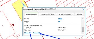
Using the cadastral number and public map on the Rosreestr website it is possible to:
- find the boundaries of the requested and neighboring plots;
- find out information about the organization serving this land.
The presence of a cadastral number of a real estate property confirms that the property has passed state registration and it is possible to carry out all transactions permitted by law with it.
How to find out the cadastral number on the cadastral map?
Find out the cadastral number online for free
possible using
a cadastral map .
This is an operational method offered by the registration authority, all information is transmitted online. How to find out the cadastral number on the cadastral map? Go to the PKK service. Access to the resource is open throughout the Russian Federation, the service will help you obtain reference information.
What data does the map display:
- Site type.
- Cadastral number.
- Cadastral engineer data.
- Status.
- Address data.
- Form of ownership.
- The market value of the allotment.
- Permitted use.
- What is on the site and what may be located (for example, a production base, a warehouse).
- Information about the cadastral organization.
To obtain information using a public card you need:
- Go to the Rosreestr resource.
- Select the public cadastral map block (it is located in front of the electronic services block).
- Select the “Plots” block (it appears in the upper right corner).
- Enter the address details of the storage device you need to find.
- Click on the search button.
Take into account! The service does not provide a detailed search; after pressing the search button, the procedure continues in manual mode.
Mandatory address data is region, district, locality, city, street, house/building number, apartment.
Why do you need a cadastral land number: algorithm of actions for obtaining
Greetings, dear readers of my site!
A cadastral number is a unique code that is necessarily assigned to any land plot for its subsequent transfer into ownership.
Moreover, today this number must be assigned to absolutely all plots, regardless of its purpose, location and form of ownership (rent, privatized or non-privatized).
These requirements were stated by the State Duma in 2007 and included in the act “On the State Real Estate Cadastre”. But how to assign a cadastral number to a land plot? What documents are required for this and who should I contact?
What is a cadastral number?
Conventionally, the cadastral number looks like XX:YY:ZZZZZZ:KK. It is not repeated on the territory of the Russian Federation and is unique for each land plot. Issued once, but can change, for example, when the land is divided into several privatized parts.
A change in the form of ownership or purpose of a land plot is not a reason to replace an already issued cadastral number.
Deciphered as follows:
- XX – cadastral district (in most cases corresponds to the region number);
- YY – cadastral district for the above district (distributed by local governing bodies);
- ZZZZZZ – number of the cadastral quarter (part of the cadastral district);
- KK – unique number of the cadastral plot.
And just from the numbers you can roughly understand where exactly the land is located. And more detailed data, including the form of land ownership, area, and so on, are stored in Rossreestr. The information is confidential and is not disclosed to third parties.
Obtaining a cadastral land number is the procedure for registering a plot of land for cadastral registration. Now it is mandatory, for example, for the privatization of land or a subsequent change in the purpose of the site.
Upon assignment of a number, a so-called “cadastral passport” is issued, which contains the following information:
- the cadastral number itself;
- detailed information about the owner of the land plot;
- category of the site (according to the current regulations of Rossreestr);
- square;
- established cadastral value, additional notes.
The owner’s possession of a cadastral passport gives him the opportunity to carry out any operations with the land at his discretion.
The main thing is the availability of documents that confirm ownership and give him the opportunity to dispose of the land in full (that is, there are no additional owners, the land has not been arrested, and so on).
Encumbrances on a land plot must also be entered in the passport (forms B.3 and B.4)
By the way, as of 2020, cadastral passports are no longer issued. They actually exist, but in a simplified digital form.
Now, to confirm the fact of assigning a number, it is enough to provide an extract from the Unified State Register of Real Estate, which in legal terms provides the same opportunities for making transactions with a land plot.
And those who have previously received a passport have the right to use both it and an extract from the Unified State Register of Real Estate at their discretion. But in the future, when the site is re-registered, the passport may be canceled (there are no such standards yet, but they will appear in the near future).
In theory, I can make transactions with land without a cadastral number. But for a potential buyer this will be a risky purchase. After all, it is quite possible that I did not receive a cadastral passport for the simple reason that I used the land for other purposes.
Accordingly, the buyer in the future will also not be able to obtain a cadastral number for the acquired land if he plans to leave it with the same target class.
That is why experts do not recommend buying such plots, since it will not be possible to obtain detailed information about them.
The basis for obtaining a number is the need to:
- purchase and sale of a house and adjacent land;
- registration of ownership of the plot (if it was not previously privatized);
- transferring a plot to inheritance (or drawing up a deed of gift);
- construction of a residential building, garage, and other outbuildings for personal use;
- transfer of land in the form of collateral (for example, when receiving a credit loan);
- execution of a lease agreement in accordance with current legislative standards;
- implementation of bankruptcy procedures (for entrepreneurs);
- transfer of the site as the authorized capital of a company or LLC;
- changing the purpose of land use (for example, when transferring from residential to commercial).
You may be interested in: How to register land ownership
Without an assigned cadastral number, it is impossible to carry out all these procedures, since the contract cannot be recognized as official. Moreover, the conclusion must be issued by a notary. And if there is a shortage of any documents (and an extract from the Unified State Register is the basis), he will be obliged to refuse me, as an applicant, to register the submitted application.
It is important to note that even if the owner is assigned to the plot (back in the days when cadastral registration either did not exist or was just beginning to operate), then the land will not actually belong to him without a registered number in the cadastre.
Registration of objects and assignment of numbers is currently carried out by the Cadastral Chamber, in some regions or districts - multifunctional centers for the provision of administrative services.
This information should be clarified with local authorities or city administration.
If the land is cooperative, then you should contact its management or simply write an application addressed to the chairman.
In other cases, to assign a number, you must submit the following documents:
- application (a sample will be issued directly by the regulatory authority);
- owner's passport;
- boundary plan (this can be obtained from a cadastral engineer).
The application is considered within 12 days (although in fact a conclusion should be issued within 5 days, but this is only relevant for large cities and regional centers).
If the decision is negative, then you need to request a complete list of documents that are necessary to register the number.
These may be documents confirming ownership, or a decision of a self-governing organization (if it is a cooperative). After this, the application is resubmitted and considered for up to 20 days.
It is worth considering that you will also need to pay a state fee and attach a receipt of payment to the application.
For individuals, the tax is 200 rubles (in Moscow and the region - up to 300 rubles), and for legal entities - up to 600 rubles.
This data is relevant only for those areas that currently have no encumbrances and are not involved in open cases with law enforcement agencies.
If the applicant still needs to obtain a land passport, he will have to pay 200 rubles for each copy. However, it must be recalled that now, in most cases, an extract from the Unified State Register is sufficient, which can be obtained from the Rossreestr representative office for free (or even order delivery of documents by mail).
To determine the cadastral value of land (which may be necessary when conducting real estate transactions), you must contact the local representative office of Rossnedvizhimost.
However, the figures subsequently indicated are not the market value. This fact must be taken into account, since in many cases it is impossible to carry out a transaction if the land is disputed. In this situation, it is much more convenient to draw up long-term lease agreements (99 years) with subsequent transfer of property. Such transactions are not entirely legal, but they allow you to avoid restrictions and encumbrances on cadastral registration.
If for some reason it is impossible to locate the legal owner of the plot, then you should contact Rossreestr with a request to provide an extract from the archive. Otherwise, you will need to go to court and refer to the fact that the person has been in control of the land for more than 15 years.
In this case, the appropriation of land is possible on the basis of the so-called “dacha amnesty”, valid until March 2020 (it is quite possible that it will continue to apply as before). However, such cases are already being considered by the court.
And the most important thing is to provide documents and evidence that the person has been managing the land for over 15 years.
This may require:
- testimony of witnesses (for example, neighbors);
- extract from the “household” book;
- land transfer act (issued back in the USSR);
- a certificate that the applicant is a member of the cooperative and pays the established membership fees;
- certificate of land allocation;
- certificates of payment of land tax;
- receipts for the purchase of seeds or seedlings that were planted on the land;
- checks issued after cultivating land (orka, cultivation).
And then you will still need to go through the procedure of land surveying and assigning a class for the use of land resources. And on the basis of this package of documents, you can contact Rossreestr to assign a number in the prescribed manner.
With lands that belong to dacha cooperatives, everything is simple in this regard.
It will be difficult only with urban real estate or those that fall under inappropriate use (for example, previously it was the territory of an industrial complex, but later it was removed and several houses were built).
It is also necessary to explain in court why the applicant does not have title documents.
If the plot was obtained during the existence of the Soviet Union, then there will be no problems with this, since then land registration as such did not exist, and the land was allocated based on orders of state companies (for example, when plant workers were allocated resources for development).
But if the land was received in 2007 and has not yet been registered, then you will have to not only confirm the ownership of the property, but also undergo engineering penalties, geodetic verification, and so on.
What does the cadastral number give?
To be assigned a cadastral number, the plot must have an owner. The owner submits documents to Rosreestr to assign a 9-digit number to the land asset. Having received a number, the land can be easily identified, open information about the geographical location, territory, coordinates, border, and owner becomes available.
KN provides legal protection, third parties do not have the right to dispose of the plot without the knowledge of the owner, the land becomes inviolable.
The owner of a memory card with an assigned number acquires the following benefits:
- Resolving conflicts with owners of neighboring plots peacefully.
- Legal settlement of disputes (often such disputes arise between owners of plots that have territorially common boundaries).
- Conducting purchase and sale transactions. The procedure will be legal.
- Avoiding fraudsters and illegal transfers of land.
- Get information quickly.
- Reliability of the information received.
A land plot with a cadastral number is considered inviolable. During the manipulations, the ownership of the asset will not be in doubt. The law protects the interests of subjects from illegal attacks - the allotment is legally protected.
How can I get a cadastral number of a land plot?
The number cannot be obtained at will, since it is assigned to the land plot during the process of its registration. Thus, to obtain a number, you must, first of all, collect all the necessary documents that are required for registration, and then contact the territorial cadastre office.
Almost all the necessary papers can be collected in the shortest possible time, with the exception of those that need to be obtained based on the results of the land survey.
Without carrying out geodetic work, assigning a cadastral number is basically impossible, and therefore you need to find a company that provides such services in advance. At the same time, it is worth asking in advance whether the selected organization has a specialized permit, since otherwise the results obtained will simply not be accepted.
If we are talking about the formation of a new plot, there will not be so many difficulties, since various problems regularly arise with old plots, related, first of all, to determining the exact location of the boundaries.
Quite often, land surveying ends in litigation with neighbors, which is why it is best to invite surveyors in advance.
In order for authorized specialists to begin carrying out all the necessary activities, they will need to provide various documents confirming ownership, and in the absence of these papers they will need to make inquiries or go directly to the court.
To obtain a cadastral number, it is necessary to confirm the existence of ownership of the land plot in question.
If no information was found, then the following data can be provided to the judicial authorities:
- any invoices confirming payment of expenses for the specified area;
- a receipt confirming payment of land tax;
- receipts or checks confirming payment for any services performed on the territory of the site in question;
- testimony from owners of neighboring plots.