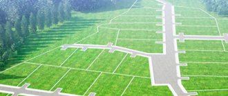
Establishing a location
Establishing a location
– this type of conclusion is prepared in the process of a complex of cadastral works.
Example
When surveying the land plot, it was revealed that the boundaries overlapped with the neighbors. The question arises about correcting the cadastral error.
Stages of work:
- examination of submitted documents
- geodetic work on site
- obtaining information from the State Tax Committee
- comparison of geodetic survey and information from the State Property Committee
At the time of comparing the information from the State Property Committee and geodetic survey, we will see a clear picture of the location of our land plot in relation to adjacent ones that have already been registered and registered with the state cadastral register.
If it turns out as shown in our drawing, then the cadastral engineer does not have the right to prepare a boundary plan to clarify the boundaries of the land plot until the cadastral error is corrected. In this situation, your land surveyor is only required to prepare a conclusion, describe the identified overlap, and provide recommendations for correcting the cadastral error.
Error in the cadastre and its correction
- According to the source of origin. This includes inaccuracies caused by government agencies; operator's; arising during data conversion, when entering information into documentation, database; appeared due to poor quality processing of source data.
- By types of cadastre data. This may include inaccuracies that were made when determining and entering the value, category of land, area, boundaries and their rotation, type of land use, etc.
- By type of responsibility for correcting inaccuracies. This includes errors that have already caused harm to copyright holders and third parties due to their actual application, as well as errors that have already been made, but have not yet gone into further work.
We recommend reading: Sample application for changing the owner of electrical networks
Errors may occur in the documentation stored in the Unified State Register of Real Estate, abbreviated as EGRN. Inaccuracy occurs when real information about an apartment, land ownership or premises is not identical to that recorded in the cadastral passport or the Rosreestr database.
Engineer services
If it is necessary to clarify the boundaries, the owner must contact the cadastral company, chamber, and make a request for the services of a cadastral engineer. Before submitting an application, you will need to collect a certain list of documents:
- Copy of civil passport.
- Certificate of ownership of property.
- Cadastral plan from the previous owner.
- A plan showing developments.
- Land surveying project.
Clarification is a paid procedure, you should be prepared for financial costs . The cost of work depends on the area of the plot and other features. Sometimes the price of the service can reach up to six thousand.
Measurement work can only be carried out using a special tool, geodetic type equipment. An engineer uses an instrument to take measurements of the territory and transfer them to the map.
Photography and other technologies are used. A soil inspection is required. If there are any unevenness in the area, they need to be measured separately.
How to correct a cadastral error
The cadastral engineer who has identified an error must not only justify the situation, but also offer his own options for eliminating the inaccuracy.
The first way to eliminate cadastral errors:
- Owners of neighboring land plots are notified of a cadastral error. Documents confirming the client's rights to the land must be attached to this document.
- In land resources, permission is taken to clarify boundaries based on the conclusion of a cadastral engineer.
- An application is submitted to the Land Resources Committee with a request to eliminate inaccuracies.
The second way to eliminate cadastral errors: contact the cadastral service together with the owner of the adjacent plot. It is suitable only for cases when friendly relations have been established with neighbors and each party is ready to make an objective and fair decision.
Many of us have heard about the activities of a cadastral engineer. Not everyone knows that his help will be required not only when establishing the exact boundaries of a land plot, but also if there is a need for legal proceedings regarding the territory of a yard or plot. Often he is able to help in a dispute that concerns the area of a residential or industrial premises. There are a number of business opinions that this professional can provide.
Diary on the practice of a cadastral engineer
| date | Workplace | Brief summary of the work performed | Supervisor's marks |
| 18.02.19 | LLC "Vega" | Preliminary briefing. Study of safety precautions and job descriptions | |
| 19.02.19 | LLC "Vega" | Collection, study and analysis of available cartographic and geodetic materials | |
| 20.02.19 | LLC "Vega" | Obtaining catalogs of coordinates of points of the reference boundary network and the state geodetic network | |
| 21.02.19 | LLC "Vega" | Obtaining the appropriate permits necessary for cadastral works | |
| 22.02.19 | LLC "Vega" | Obtaining information about cadastral division, land category and other necessary information from the State Real Estate Cadastre | |
| 25.02.19 | LLC "Vega" | Identification and inspection of objects | |
| 26.02.19 | LLC "Vega" | Determination of the coordinates of characteristic points of the boundaries of an object on a land plot, determination of boundaries and area, using information from the State Real Estate Cadastre | |
| 27.02.19 | LLC "Vega" | Formation and analysis of the resulting measurements | |
| 28.02.19 | LLC "Vega" | Analysis and processing of information about the object obtained as a result of geodetic measurements | |
| 1.03.19 | LLC "Vega" | Analysis of the location of the object on the land plot in relation to the information available in the state real estate cadastre | |
| 2.03.19 | LLC "Vega" | Collection, study and analysis of available cartographic and geodetic materials | |
| 4.03.19 | LLC "Vega" | Obtaining catalogs of coordinates of points of the reference boundary network and the state geodetic network | |
| 5.03.19 | LLC "Vega" | Obtaining the appropriate permits necessary for cadastral works | |
| 6.03.19 | LLC "Vega" | Obtaining information about cadastral division, land category and other necessary information from the State Real Estate Cadastre | |
| 7.03.19 | LLC "Vega" | Identification and inspection of objects | |
| 9.03.19 | LLC "Vega" | Determination of the coordinates of characteristic points of the boundaries of an object on a land plot, determination of boundaries and area, using information from the State Real Estate Cadastre | |
| 11.03.19 | LLC "Vega" | Determination of the internal parameters of the object, including the number, numbering and purpose of premises, configuration and linear dimensions of premises | |
| 12.03.19 | LLC "Vega" | Preparation of technical plans for facilities in accordance with the current legislation of the Russian Federation in paper and electronic form | |
| 13.03.19 | LLC "Vega" | Formation and analysis of the resulting measurements | |
| 14.03.19 | LLC "Vega" | Consultation with the supervisor, discussion of the work done | |
| 15.03.19 | LLC "Vega" | Analysis and processing of all obtained results | |
| 16.03.19 | LLC "Vega" | Writing a report |