Home / Real estate / Land / Land surveying
Back
Published: 03/05/2017
Reading time: 7 min
0
515
Starting from the new year 2020, in order to carry out various transactions with plots of land, it is necessary to carry out boundary surveys.
In our article we will describe in detail the legislative norms in the field of land surveying, and also tell you what needs to be done if your neighbor refuses to sign the necessary documents and in what cases boundary surveying is carried out without the consent of the neighbors.
Land surveying - determining the boundaries of a land plot in a certain area.
Boundaries are fixed based on the installation of special boundary signs and are recorded in the boundary plan of the land plot.
It is important to be able to distinguish between cadastral work with a plot of land and boundary surveying, despite the fact that these concepts are related, in fact they differ from each other. Cadastral activities are carried out to record real estate and land in the state, while land surveying is part of cadastral work with a site and comes down to determining the boundaries of the site, its actual area and location.
Surveying the boundaries of a land plot in the Russian Federation is permitted only to experienced and certified specialists
- cadastral engineers.
Therefore, to carry out legal land surveying, you will, one way or another, have to turn to educated specialists. Do not forget that the foundations of land surveying, which are laid down by law, are common to all regions of the Russian Federation; in each individual district, city or region, land surveying may differ depending on local regulations, therefore, turning to cadastral engineers for help is important Also review the laws in your area.
- Legislative norms
- In what cases is land survey coordination with neighbors not required?
- What to do if a neighbor interferes with boundary surveying?
Notifying neighbors
In relation to undemarcated lands, the owner does not have the right to perform legally significant actions - sell, donate, lease.
Therefore, the owner needs to carry out land surveying and determine the boundaries of the territory. To do this, you should contact a specialized company engaged in land work. To conclude an agreement, you will need a passport of the owner of the land and title documents for the allotment. The owner of the site is obliged to notify in writing other interested parties, that is, the owners of adjacent territories, about the upcoming land surveying work. In this case, the notice period must be at least one month before the date of the planned work.
From the moment the notification is received, the interested party may object to the upcoming work. If no written objections are received, then the notification is considered valid.
Neighbors must be present when land surveying is carried out and can express their disagreement with the work carried out in writing. If interested parties, duly notified, do not appear for the survey, then the work will be carried out in their absence.
What is included in the notice
According to paragraph 9 of Art. 39 of Federal Law No. 221-FZ of July 24, 2007, the notification contains the following information:
- information about the customer and cadastral engineer;
- address and cadastral number of the territory;
- procedure for familiarizing yourself with the draft boundary plan;
- date, time and place of survey;
- the address to which interested parties can send their objections.
If one of the neighbors refuses to accept a notice issued in the prescribed manner, then such person is considered to have been properly notified.
How to coordinate the boundaries of a land plot with neighbors?
To determine the boundary boundaries of neighboring lands, you need to call an engineer who will carry out cadastral work. Interested parties enter into a contract for the provision of services with the master. Coordination must be carried out in the presence of the owner of the site.
The specialist has the right:
- agree on the issue of land surveying with each of the plot owners separately;
- hold a meeting of neighboring land owners.
Owners of real estate must be informed one month in advance about the meeting in writing. The notification can be transmitted to interested parties personally, sent by post (registered mail) or by e-mail.
Any of the owners can declare the need to coordinate the boundaries of objects.
It is important to notify all persons whose interests may be affected by this procedure. You can find out information about the owners of neighboring lands at the nearest branch of Rosreestr or MFC.
On the day specified in the notice, the engineer meets with the owners of the plots to sign a boundary approval act.
Based on this document, corrected information about adjacent lands is subsequently entered into the USRN database. After the cadastral work has been carried out, this act must be signed by each owner.
Useful material : What is industrial land?
How is land surveying carried out?
Cadastral work takes place in the following sequence:
- Conclusion of an agreement.
- Collection of information about the site.
- Notification of interested parties.
- Departure to the territory for inspection.
- Preparation and signing of an act of approval of boundaries with all owners of adjacent plots.
- Execution of graphic drawing.
- Drawing up a boundary plan.
Boundary approval acts are a mandatory appendix to the boundary plan. Based on these documents, the land is registered in the cadastral register.
During the execution of boundary work on the customer’s territory, the cadastral engineer explains to all owners the measurements taken and the accuracy of their implementation. Owners of adjacent territories must read this information and sign an agreement.
The signing of the act confirms that all interested parties agree with the calculations made. If relations with neighbors are good, then work can be carried out in their absence by prior agreement. The main condition for this is the subsequent signing of the act.
The land surveying procedure is considered legal and competent only if the act of boundary approval is signed by all owners of adjacent plots.
What to do if neighbors do not sign the act of agreeing on boundaries when surveying
Conflicts often arise between the owners of adjacent territories when clarifying the boundaries of plots. Every Arbitration Court is filled with similar proceedings.
In addition to the abundance of claims, lawyers consider insufficiently competent documentation to be another serious problem.
Claims filed improperly are not accepted for consideration, disputes are not resolved, and conflicts continue to grow in intensity. What to do if the neighbors do not sign the agreement.
What to do if neighbors do not sign the boundary agreement document
In cases where neighbors are not ready to engage in constructive dialogue and resolve the conflict by carrying out boundary work, the only option left is to go to court. To obtain a satisfactory court decision, you will have to secure a certain legal competence.
One of the mandatory conditions for carrying out boundary work is to fill out a boundary agreement document with neighbors. The approval procedure is standard.
When planning to begin surveying a plot of land, the owner of the plot must notify neighbors of his intentions. This must be done at least a month before the scheduled date of the specialist’s visit to the area.
In most cases, the cadastral engineer selects one day for all owners of adjacent territories. The notification is issued against signature.
The owner of the site prepares a boundary approval act in advance in order to begin filling it out on the appointed date. The deed must be signed by neighbors.
The act will act as an annex to the land survey and will indicate the legality of the land survey procedures. Dependence on neighbors does not bode well for the initiator of the work.
Since the issue involves property rights, you should not rely on trust relationships.
If you understand perfectly well that the neighbor will refuse to accept the notice and sign the act of approving the boundaries, then the documents must be sent by mail in the form of a registered letter. A notification of delivery of correspondence is required. The document is extremely necessary, since in court it will be the main confirmation of the competence of the actions taken by the initiator of the land survey.
Lawyers recommend sending such letters three times. After these actions, the notification acquires the permanent status of the addressee’s signature. The notification becomes effective only if a month has passed since it was sent, and during this period the neighbors have not made any attempts to contact you or taken other actions to resolve the issue.
You can check with the specialists of the cadastral company that will provide services about the need for boundary work. Sometimes land surveying is carried out on the basis of an act of approval of boundaries and a postal notification of the receipt of relevant correspondence by the neighbor.
This is only possible in cases where the neighbor does not plan to attend the border coordination activities. Since you strictly followed the rules of procedure, winning your case will not be difficult.
The neighbors do not sign the act of coordinating the boundaries and are not present during the work of the surveyor and cadastral engineer, then the situation will develop differently if the neighbor prepares a written claim, which will indicate a refusal to sign the act and list the grounds for making such a decision. Sometimes neighbors, having received an invitation, personally attend the survey and voice their complaints.
The greatest importance in such cases is given to the legal relations that bind landowners. To solve the problem unilaterally, you will inevitably have to go to court. To win the case, it is important to correctly select the algorithm for further actions.
Legal relations between owners of adjacent territories may be of the following nature:
- both have shares in the collective property;
- both are the owners of the objects;
- one is the owner, and the other owns the land on the right of perpetual use (inheritable ownership for life).
Regardless of the nature of the relationship between the parties, the stage of sending notifications about the need to sign an agreement remains mandatory. Ignoring the listed conditions threatens the initiator of the measures with negative consequences.
If the neighbors win the case to declare the results of the survey work illegal, then you will lose money and will not receive compensation for it.
Possibilities for carrying out land surveying without the consent of neighbors
The consent of neighbors is not necessary in cases where:
- three times they sent registered letters with notifications containing a requirement to sign the act. The frequency between sending letters should be 2 weeks. No response was received to the letters;
- the warning was contained in a registered letter sent to a neighbor. The addressee did not make counterclaims and did not respond. The notification form is attached to the boundary approval act as an appendix. This applies to cases when neighbors do not appear on the site and you do not know their actual location.
There are many reasons why difficulties arise when signing documents. There are quite common cases when a neighbor is on vacation or a long business trip and is not able to personally sign. Some modern people have already begun to actively use electronic signatures, but there are only a few of them.
In the above cases, you will have to seek a compromise with the neighbor’s close relatives and ask them to agree on the act of locating the borders. You can also ask your neighbor to send a written notification that there are no complaints regarding the organization of boundary work in the area.
The document will act as an annex to the border approval act and will have official force.
If the neighbors do not sign the act of coordinating the boundaries, presenting their arguments, it is impossible to avoid going to court. If the opponent himself becomes the initiator of the conflict, then it is enough to indicate in the claim the reason why he refuses to sign the act. Let him deal with any complaints on his own.
If you have previously violated the boundaries between territories, then it is better to restore justice voluntarily.
If a neighbor violated your rights, and you initiated a land surveying procedure that was undesirable for him, then the claim must reflect the details of the existing violations and provide facts to support them.
This will contribute to the resolution of a long-standing conflict by organizing boundary procedures, and will also restore the legal boundaries of the lands. If the violations committed by a neighbor infringe on your property rights, you can recover additional compensation from him.
Owners of shares in a common plot should do the same. Land surveying will allow you to allocate a share and issue documents on full ownership for it. To move in this direction, you must first obtain a certificate confirming that the share corresponds to the standard values of the areas of independent plots.
If you have land at your disposal, but the size of the share is not determined by common law, then the first step should be to establish the size of the share in relation to the residential premises you own. At the legislative level, it is possible to disassociate in favor of the owner of the premises the area of land under the building that corresponds to the size of the share in the rights to the premises.
In such a situation, the claim should include a requirement to allow the allocation of a share from the common property through the organization of land surveying.
Moszemcom company statistics on this issue in the context:
Year of controversial issues Came to a settlement In court Court in favor of the client
| 2016 | 31 | 24 | 7 | 6 |
| 2017 | 46 | 37 | 9 | 7 |
| 2018 | 12 | 11 | 1 | 1 |
Conclusion
Notification of upcoming boundary work must be sent to neighbors a month before the start of the procedure. Notifications are sent to neighbors in writing and subject to the personal signature of the applicant.
Together with specialists, you can find the best way out of a situation where neighbors do not sign the act of coordinating boundaries.
You should start filing a claim only at the moment when all pre-trial procedures have been completed; the chances of a voluntary settlement of the conflict are minimal.
The case will be accepted by the minister of Themis for consideration only on the condition that a comprehensive set of documentation is provided, and the statement of claim itself is properly drawn up. Sometimes landowners resort to cunning and try to forge the autographs of their neighbors.
It is better to abandon such an undertaking immediately, since it results in very serious consequences.
It’s better to do everything right before the first trial, even if you think that the case is very easy and the court will definitely rule in your favor. During an appeal, it is much more difficult to refer to new evidence in the case. Play it safe! If you have any questions, call me (Anastasia)
Source: https://moszem.com/sosedi-ne-podpisyvaut-akt-soglasovaniya-granic/
Reasons for neighbor's disagreement
A neighbor may refuse to sign the act both for subjective reasons, for example, personal hostility, and for completely objective reasons:
- incorrect determination of the coordinates of turning points;
- crossing or overlapping the boundaries of adjacent lands;
- errors in documents caused by human factors;
- contradictions between previously issued documents and newly received measurements;
- unauthorized seizure of part of someone else's land.
Disputed boundaries of territories can be a consequence of both the mistakes of surveyors who previously carried out measuring work, and the imperfection of legislation. Previously, cadastral work was not mandatory for cadastral registration. In addition, modern equipment, with the help of which the boundaries and area of territories are determined, is more accurate than the instruments used 10 or 20 years ago.
If a neighbor has a reasonable disagreement with the work carried out and the establishment of new boundaries of the territories, then he has the right to submit them in writing.
In accordance with paragraph 4 of Art. 40 of Federal Law No. 221, the cadastral engineer must make entries in the boundary approval act about any objections from interested parties. The written objections themselves are attached to the boundary plan and are an integral part of it.
Analytics Publications
A wide variety of situations arise. For example, a large development company acquires a large plot of land in the city center, the boundaries of which are adjacent to the boundaries of the plot on which a small house or garage is located. But when the question of surveying a land plot and coordinating boundaries with an adjacent land user is raised, the development company is faced not with an ordinary citizen - the owner of the building, but with a professional lawyer or an official with authority who agrees to sign the necessary act, but on “certain conditions”. The scheme is approximately the same, only the characters change. An indicative case occurred in 2006 in the Moscow region. According to the investigation, the head of the rural settlement did not sign the approval act until TDM LLC (an organization wishing to register its land plot) entered into a purchase and sale agreement for a land plot measuring 7 hectares with his wife. A criminal case was eventually opened against the official.
Natural questions arise: does the law really not provide a way to avoid blackmail? How to quickly and correctly overcome opposition?
Sue or settle?
On March 1, 2008, the new Federal Law “On the State Real Estate Cadastre” came into force, which, in particular, was intended to eliminate the existing rule-making gaps when registering real estate for cadastral registration. Unfortunately, it did not eliminate all the pitfalls that an individual or organization wishing to enter information about a property into the state cadastre may stumble over.
Today, in order to register a land plot for cadastral registration, it is necessary to submit to the territorial department of the Federal Cadastre Agency (hereinafter referred to as the Cadastral Chamber) an application accompanied by documents, the composition of which is determined by Art. 22 of the above-mentioned law (in particular, this is a boundary plan, an integral part of which is the act of agreeing on the location of the boundaries of a land plot with adjacent land users).
The law provides for three results of border coordination:
- the adjacent land user signs the act;
- the adjacent land user, duly notified, does not sign the act, about which a corresponding note is made in this act. This case speaks of the neighbor’s indifference to the boundaries of his and adjacent land plots and is interpreted as consent;
- the adjacent land user refuses to coordinate the boundaries, about which a corresponding note is also made in the act.
There are no difficulties with the first two options: the boundary plan is successfully approved. With the third option, big problems arise, the solutions of which are not provided for by law.
In accordance with the Decree of the Government of the Russian Federation “On the Federal Agency for the Cadastre of Real Estate Objects”, boundary matters are approved by the Cadastral Chamber. It is endowed with a wide range of powers, including the ability to conduct state examination of documents, the right to request and receive the necessary information. And, for example, in the case when an adjacent land user justifies his refusal to approve the boundary with a non-existent document, representatives of this body could easily check the legality of such an action. (It would also be advisable to legally oblige the adjacent land user to provide copies of documents with which he confirms his refusal. Such an obligation would discourage most unscrupulous neighbors from making easy money - not everyone will decide to falsify documents.)
In the current situation, having received a land survey case with a refusal, the Cadastral Chamber, as a rule, simply does not approve the land survey plan, giving the parties the opportunity to defend their position in court. However, the prospect of a lengthy trial scares off some owners, and they prefer to “amicably” deal with the “adjacent” companies, satisfying their appetites.
Those who went to court face their own pitfalls. The fact is that the legislation does not provide for any specific method of protection in such a situation, and the person who filed the claim runs the risk of having the stated claims rejected.
Practice in this regard is very contradictory. The Federal Arbitration Courts of some districts in their decisions (see, in particular, the Resolution of the Federal Arbitration Court of the Moscow District dated 09.19.2007 in case No. KA-A41/8261-07; the Resolution of the Federal Arbitration Court of the West Siberian District dated 06.14.2007 in the case No. Ф04-3727/2007) allow for the possibility of forcing an adjacent land user to agree. At the same time, in the decisions of the Federal Arbitration Court of the North Caucasus District (see, for example, Resolution of the Federal Arbitration Court of the North Caucasus District dated June 17, 2008 in case No. F08-29b 1/2008; Resolution of the Federal Arbitration Court of the North Caucasus District dated 12.03.2008) arguments are given indicating the impossibility of satisfying such a requirement. The main one is that, in accordance with the law, approval of an act is a right, not an obligation.
The Cadastre Law states that refusal to approve boundaries is an integral part of the act of approval of the boundaries of a land plot and is filed with it. In turn, the approval act must be filed in the boundary plan. From this we can conclude that the legislator does not allow the possibility of drawing up a new approval act, which the adjacent land user will have to sign by court decision.
What and from whom to demand
So, what kind of claim should you go to court with? In this situation, it is most appropriate to appeal the refusal to approve the boundary plan by the Cadastral Chamber - in this case, the court will examine the legality of its actions (inaction): after all, it was the Cadastral Chamber that made the decision to refuse, violating the rights of the person who applied for approval of the boundary plan. However, filing such a claim does not guarantee a successful outcome. To clarify all the circumstances, the court will be obliged to involve an adjacent land user in the case as a third party who does not make independent claims. In this type of case, the grounds for the acquisition of disputed land plots are verified, as well as all documents referred to by the parties, that is, the land dispute is resolved.
Appealing the actions of the cadastral registration body is also more appropriate from the point of view of the subsequent execution of the court decision. Having declared the actions of the cadastral chamber illegal, the court will oblige it to approve the boundary plan. Being a state structure, the Cadastral Chamber will not be able to delay or complicate the enforcement of a judicial act, since, according to Art. 315 of the Criminal Code, failure to comply with a judicial act threatens civil servants with criminal liability.
In the case where the court obliges an adjacent land user to agree on the boundaries of a land plot, the process of executing a judicial act can drag on for a very long time - especially if the would-be neighbor purposefully refuses approval, planning to earn extra money from it.
Where should the owner of the plot contact if the neighbor does not sign the deed?
Having read the written objections of interested parties, the owner first of all needs to try to peacefully resolve the conflict situation. To do this, you can look up archival information about the history of the plot, compare your neighbor’s cadastral passport with the newly obtained data based on the results of the land survey, and try to prove your case with documents.
If nothing works, and the neighbor still claims part of the adjacent territory, then you need to contact a special land management committee under Rosreestr. The controlling body will carry out the necessary measuring procedures and determine the correctness of the land survey by the cadastral engineer.
The next step is to file a complaint with the prosecutor's office. The complaint states that the neighbor is violating the rights to use the land or has illegally taken possession of part of the plot.
The final authority to resolve a dispute regarding the boundaries of a property is the court. The judicial authority will not force the interested person to sign the act of coordinating boundaries. But, having considered all the materials and arguments of both sides, the court will establish the boundaries of the territory. The land will be registered with Rosreestr based on a court order.
The procedure for approving the boundaries of the site
Documentation of the approval of boundaries consists of the signing of the corresponding act by all participants in this procedure. Signing the document is possible both individually with each owner and in the process of group approval of boundaries.
It is necessary to notify the owners of adjacent plots of the intention to carry out boundary work with subsequent approval of boundaries no later than a month before the proposed procedure. Participants must sign the notification. You can notify owners whose whereabouts you do not know by publishing an advertisement in a state newspaper.
The announcement must contain information about the cadastral engineer who will carry out the survey work, the date, time and place of the work, as well as the location of the meeting of participants in the approval procedure.
Failure of the owners of adjacent land properties to appear at the appointed place and time should be regarded as consent.
The procedure for agreeing on the limits of land plots is regulated by the federal legislation of the Russian Federation and includes the following stages:
- Contacting a cadastral engineer (state or private licensed organization) with an application to carry out land surveying work;
- Coordination of the work procedure with a specialist;
- Obtaining advice from a cadastral engineer;
- Conclusion of a contract (agreement) for the provision of land surveying services;
- Notification of owners of adjacent plots.
At this stage, send a notice to all interested parties and obtain their signatures. This way, the owners will be properly notified of the upcoming procedure. On the appointed day, all participants must sign an agreement, which is sent to the State Cadastre.
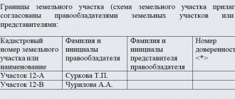
The act of agreeing on the boundaries of a land plot with neighbors.
Read about the procedure for agreeing on the boundaries of a land plot with neighbors here.
How to carry out land surveying without the consent of neighbors, read the link:
In some cases, approval of the boundaries of the land property is not required. If the owners of adjacent plots have carried out land surveying and registered all changes in the Cadastre, then there is no need for approval.
In this case, the cadastral engineer makes all changes previously made to the Cadastre into the act. Such an act does not need to be signed by the owners of adjacent plots. Other participants are notified in the manner described above (via the media). In the absence of any objections received from them, the act is considered agreed upon.
Repeated notification of owners of neighboring plots is carried out before carrying out land surveying work. As a result of the work carried out, the boundaries of the plots previously registered in the Cadastre will be highlighted in one color in the boundary plan, and the new boundaries will be highlighted in another.


![eCabbage [CPL] RU](https://standart-rzn.ru/wp-content/uploads/ekapusta-cpl-ru-330x140.jpg)