Cadastral plan of the land plot
In accordance with changes in cadastral legislation and the abolition of the cadastral passport, starting from 2020, an extract from the Unified State Register has been introduced.
All the basic information of the cadastral passport is reflected in the new cadastral document, including the cadastral plan of the land plot. To order an extract from the Unified State Register of Real Estate, you must complete the following steps: The map is placed on the service of Rosreestr, the body that carries out state cadastral registration of real estate. It displays all objects, information about which is included in the State Property Committee. The cadastre is publicly accessible and cadastral map information is provided to an indefinite number of persons free of charge.
Where to apply to obtain an extract from the Unified State Register of Real Estate
Dear readers!
Our articles talk about typical ways to resolve legal issues,
but each case is unique. If you want to know
how to solve exactly your problem - call the following numbers:
8 — Moscow 8 — St. Petersburg 8 (ext. 604) — Russia (general)
or if it’s more convenient for you, use the online consultant form!
All consultations with lawyers are free.
To obtain an extract from the Unified State Register, you can contact almost any multifunctional center (MFC). In some regions, this service is provided in the offices of the Federal Cadastral Chamber of Rosreestr.
The request can also be submitted online, through the electronic service of Rosreestr on the website rosreestr.ru. But, unfortunately, as of the beginning of February, all electronic services of Rosreestr are unavailable due to technical work on the site, which has been ongoing since the beginning of 2020.
To submit a request for information, you must present a passport or other identification document to the employee accepting documents. If a fee of the appropriate amount has been paid by the time the request is submitted, a check or receipt will also be provided.
Based on the information provided, the employee responsible for admission will make a request for information.
It is very important to indicate the cadastral number of the land plot in the request. According to the new request form, this information must be provided. Otherwise, the chances of receiving an extract from the Unified State Register of Land Registration for a land plot tend to zero.
The result of consideration of a request that does not contain a cadastral number will be either a refusal to provide information or a notification that the requested information is not available in the Unified State Register.
It is necessary to pay attention, since such results are undesirable for the applicant, including because the fee paid for the issuance of information cannot be returned or reused, the cadastral number of the land plot must be found out in advance.
If a land plot was formed and provided for ownership or use before October 30, 2001 (before the Land Code came into force), then such a land plot is previously registered and information about it is most likely already contained in the Unified State Register of Real Estate. In this case, you can find out the cadastral number of the plot yourself by finding the plot on the public cadastral map - an electronic service on the Rosreestr website.
Having found out the cadastral number and submitted a request for an extract from the Unified State Register of Real Estate on the main characteristics and registered rights to the property in relation to the land plot, if the fee for information was not paid before submitting the application, the MFC specialist will issue a receipt containing a unique accrual identifier (UIN ), according to which payment should be made.
Payment by UIN number can be made both in most instant payment terminals and in Internet banking systems (Sberbank Online, VTB24 Telebank, etc.).
It is very important to make payment after submitting the request using the UIN. Only using this unique identifier will the Federal Cadastral Chamber of Rosreestr be able to establish a connection between a specific request and the received payment
. The requested extract from the Unified State Register will be provided within three working days after the department receives information about payment.
In conclusion of the article, it would not be amiss to recall that an extract from the Unified State Register of Real Estate on the main characteristics and registered rights to a real estate property, like the defunct cadastral passport of a land plot, is just a certificate, the information in which, according to Federal Law No. 218-FZ, is relevant and reliable only at the time of its issuance by the MFC or the Federal Cadastral Chamber of Rosreestr.
How to obtain a cadastral plan and a cadastral extract, see the lawyer’s advice in the following video:
Attention!
Due to recent changes in legislation, the information in this article may be out of date! Our lawyer will advise you free of charge - write your question in the form below:
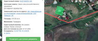
Looking at the cadastral plan of a land plot online , not everyone understands the meaning of the numbers presented. The indicated numbers are cadastral numbers.
Cadastral land plan online
Procedure for registering a cadastral plan of a land plot
- The electronic procedure is cheaper for the applicant than a personal application to the government service.
- The registration period takes no more than 1 hour from the moment of application, whereas for personal application the period is 5 days.
- Convenience comes first, because from any available computer - at home or at work, you can send an application to the government services portal.
- An electronic document has equal legal force as a traditional paper document.
- By contacting the government service through the portal, you receive a lot of additional information that is difficult to obtain in any other way.
- Payment of the state fee can be made immediately when submitting the application online, using an electronic means of payment.
The main basis for drawing up a cadastral plan is the separation of this site from some other site. In this case, you have to draw up a new cadastral plan. If there is a change of owner, the cadastral plan requires its re-registration.
When is it possible to refuse to make changes?
The owner of a land plot must understand that in some cases, changes to the cadastral passport may be refused. The reasons are due to incorrect documentation:
- the package of documents has not been collected completely, some important documents are missing;
- when submitting an application by the principal, copies of documents are drawn up incorrectly, the power of attorney has expired or it is drawn up with errors;
- incorrect completion of the application for amendments to the cadastral passport;
- making adjustments violates the current legislation of the Russian Federation.
To avoid refusal and additional hassle with documents, we advise you to submit your application in person.
This method of handling has several advantages:
- significant savings in money (if you submit an application through a representative, you will have to notarize copies of documents, as well as draw up a power of attorney; if you send documents by mail, you will also have to attach notarized copies and pay for postage);
- the opportunity to consult with government agency employees; any errors that may arise can be corrected immediately on the spot.
But if you are still denied, before filing a claim in court, we advise you to double-check the prepared documents and resubmit your request. If you are denied a second time, then you should go to court by filing a lawsuit demanding adjustments to the current cadastral passport.
There is nothing complicated in submitting an application to make adjustments to the cadastral passport - you just need to correctly prepare all the necessary documents.
Dear readers, the information in this article may be out of date. If you want to know how to solve your specific problem,
call the phones
:
- Moscow: +7(499)350-6630.
- St. Petersburg: +7(812)309-3667.
Or on the website. It's fast and free!
What documents will be required? The first document that is required to draw up a cadastral plan is an application. In it, the owner of the site indicates all the information and grounds necessary for drawing up the plan
.
Based on the application, a comparison of the land survey plan will be made, and then a cadastral plan will be generated. You can obtain a special application form from the cadastral chamber
.
If your territorial authority does not have a special form for submitting an application, then the application is drawn up according to the sample that can be seen on the government services portal. In addition to the application, the owner will need to provide copies of his passport, as well as a title document
. It is also necessary to pay the state fee and provide the corresponding receipt as confirmation.
How can I get a cadastral plan of a land plot?
When submitted to the Cadastral Chamber, all documents must be registered in a special journal. Using this record, you can clarify the time of receipt of documents, as well as prove the presence of documents at the time of delivery. The applicant receives a receipt from the KP employee, indicating the acceptance of each document.
Obtaining a cadastral plan of a land plot has been regulated since February 20, 2008, in accordance with the order of the Ministry of Justice of the Russian Federation. At the moment (since 2010), we can say that cadastral registration in Russia is in a transition period, but a new type cadastral passport can already be obtained from the Cadastral Chamber or the MFC. However, some stages of the procedure for obtaining a document may change in the future, so it is better to clarify the list of documents required for issuing a cadastral passport and plan in Rosreestr or in consultation with Star-Service specialists.
Increasing the area of the land plot while clarifying the boundaries from 2020
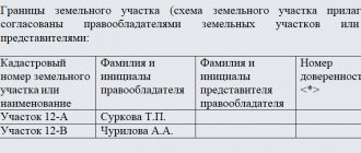
Clarification of part of the border of an adjacent land plot or other land object requires the provision of a certain package of documents: Preparation of a letter with the cost, timing of the examination and information about the expert contractor. A determination is made to appoint an examination to our company. Changes in legislation have made the procedure for land surveying mandatory, but, as practice shows, not all owners have completed this procedure. We recommend that you take care to clarify its boundaries, otherwise, along with your own plot, you risk acquiring boundary disputes and litigation with your neighbors.
When confirming the actual location of the boundaries of a land plot, it is possible to use both the cartographic basis of the state real estate cadastre, maps (plans), which are photographic plans of the area on a scale of 00 and larger, as well as situational plans of the BTI, master plans (development plans) of the territories of horticultural, vegetable and dacha associations of citizens , approved in the prescribed manner, and other documents. Clarifying the boundaries of a land plot is a type of land surveying procedure, during which a specialist, using special equipment, determines the coordinates of the turning points of a specific plot of land. From 2020, without surveying (clarification of the boundaries) of the land plot, it will be impossible to make any transactions related to the land. Work to clarify the boundaries of the land plot is completed by preparing a survey plan.
We recommend reading: Passing the Traffic Regulations 2020 Wrong Answers
How to make changes to the state cadastre
Regarding the correction of errors, this is a special procedure provided for by law. Correction of errors is carried out either at the initiative of the cadastral authority, or at the request of any person, or by court decision. In any case, the authorized body makes a decision about the identified error and eliminates the error within five days, of which interested parties are notified.
We recommend reading: Should a group 3 disabled person pay transport tax?
Information about a property may change over time for various reasons. It is advisable to reflect such changes in the cadastre. Otherwise, the contradictions that arise may become an obstacle to transactions and other manipulations with real estate, or greatly complicate their completion, as well as negatively affect the implementation of other rights of the owner.
Increasing the area of the land plot while clarifying the boundaries from 2020
You need to have legal documentation, a purchase and sale agreement, a certificate of inheritance, and so on. According to the adopted dacha amnesty, the increase in territory is carried out on the basis of a redistribution agreement.
In some situations, it is possible to expand the land allotment. The main thing here is not the actual use of adjacent lands, but the issue of legal registration of this fact. Clarification of the boundaries of a land plot with an increase in area is considered a legal procedure for the legal registration of additional territory by annexation to the main plot. In other situations, the procedure directly relates to the reorganization of plots - through the purchase or re-registration of adjacent plots. The law allows for the recognition of property rights through a judicial authority.
We recommend reading: Help for Young Families in 2020 in Bashkiria
Making changes to the cadastral registration of a land plot
- land owners;
- persons to whom the land belongs by right of inheritance;
- persons who have the right to unlimited use of the site;
- persons in whose favor there are restrictions and/or encumbrances on the land;
- representatives of the categories listed above who have a notarized power of attorney from them to carry out actions to make changes to the cadastre;
- Location (that is, the address, and in its absence, a description of the location).
- Data on rights to the site and their owners to the extent contained in the Unified Register of Rights.
- Information about restrictions and/or encumbrances, as well as in whose favor they are established.
- If restrictions are not valid for the entire site, then data about the part for which they are valid.
- Data on the cadastral value of land, as well as the date on which such value was established.
- Data about natural objects (reservoirs, forests, etc.) that are located on the site.
- Category of land.
- Type of permitted use (purpose) of the site.
- Contact information for communicating with the owner or person who has the right of lifelong ownership of the land;
Changing the boundaries of a plot in the cadastre
Advice from lawyers:
1. A lawsuit was filed in court to establish the boundaries of the land plot, because the neighbor wrote an objection when preparing the boundary plan. The documents were submitted to the cadastre. The cadastre naturally suspended and subsequently refused to set boundaries. The claim was filed in court, but it turned out that the cadastral engineers made a mistake in the coordinates. Do I now have the right to clarify the claims in terms of changing the coordinates of two points or will I have to go through the entire procedure again before filing a new claim?
1.1. Check your claims. During the judicial review, cadastral engineers will carry out a new reference to the marks, this will be the basis for making a court decision. Sincerely.
Did the answer help you?YesNo
Consultation on your issue
8
Calls from landlines and mobiles are free throughout Russia
2. Do I have the right to install pegs along the border of my plot if its coordinates are approved by the court, but information about their changes has not been entered into the real estate cadastre?
2.1. Good day! YES, of course - if the court decision has entered into legal force, you have this right. Good luck to YOU! Always happy to help.
Did the answer help you?YesNo
2.2. Good day. If the coordinates have already been approved by the court, then you have every right to install, among other things, pegs along the border. Good luck and all the best.
Did the answer help you?YesNo
3. We carried out a repeated survey, clarifying the boundaries of the site and annexing the no-man's land between us and our neighbors. The cadastre issued new documents with the latest boundary changes. How to properly install boundary signs so that there are no obstacles from neighbors.
3.1. Good afternoon Install boundary signs in accordance with the new documents on the registration of the land plot with cadastral registration.
Did the answer help you?YesNo
3.2. In accordance with the Decree of the Government of the Russian Federation of August 20, 2009 N 688 “On approval of the Rules for establishing the boundaries of land management objects on the ground,” when installing a boundary sign, it is oriented so that its front side (with inscriptions) faces the next boundary sign when moving along the border clockwise.
Did the answer help you?YesNo
4. I am the owner of a plot of land in the garden. In preparation for the transfer of agricultural land to residential land, my plot was demarcated outside the boundaries of the collective garden. A cadastral error has occurred. The site was interleaved when changes were made to the state real estate cadastre - “settled areas”. I was denied a plot within the boundaries, a former garden. Conditions for land use have deteriorated significantly. How can I defend my rights? Who is the defendant?
4.1. Who is the initiator of the transfer of land from the category of agricultural use to settlement land? Let the customer of the work correct it. To do this, it is necessary to submit a written claim to the customer and if they refuse or do not respond, go to court to recognize the ownership of the land within the boundaries of the Civil Code of the property.
Did the answer help you?YesNo
5. I own 1/2 of the plot, they made changes to the boundary plan, dissociated themselves, Rosreestr does not issue a cadastral passport without the second owner (he disappeared). We need a court, the question is, should we file a boundary plan or an examination in a claim? To establish and register boundary boundaries and obtain a cadastre.
5.1. Hello! Since the consent of the second owner is needed, but it is not there, then you need to file a claim in court to establish the boundaries of the land plot according to the turning points established in the boundary plan.
Did the answer help you?YesNo
6. Please, when changing the permitted type of use of land to land plots that are in shared ownership as shares in the right, is the consent of all shareholders (for example, a certain cadastre) required to formalize the change in the permitted type of use of land plots located within the borders of one cadastre?
6.1. Hello! Yes, an application is required from all owners.
Did the answer help you?YesNo
7. Is the decision of the arbitration court the basis for registering land? plot without a boundary plan, if the resolution states: this court decision is the basis for amending the state. real estate cadastre in order to establish new boundaries and land area. plot"
7.1. No, it is not such a reason. In order to make changes to the cadastre, land surveying is necessary.
Did the answer help you?YesNo
7.2. Hello! No is not. It is imperative to provide a land survey document.
Did the answer help you?YesNo
8. The boundary plan was drawn up incorrectly (incorrect boundaries of the site and the area was reduced) and this incorrect information was put on the treasure table. The area in the certificate remained correct (it is larger than in the cadastre). What to do? How to make changes to the cadastre?
8.1. Submit an application to correct the cadastral error or go to court.
Did the answer help you?YesNo
9. Changing the boundaries of a land plot without changing the area of more than 10% of the boundaries are not defined. The plot was purchased in 1996 and attached to the certificate is a plot plan that differs from today’s. There is an aerial photograph of the site from 1995 with the removal of site location points that coincide with today's location. The plot was not entered into the cadastre based on the actual use of the land plot. Is it possible to put a plot of land on cadastral registration after the fact, with or without a court, and who will take it?
9.1. Valery, you will not register your land plot using the documents that you have. You need to contact a cadastral engineer and prepare a boundary plan along the actual boundaries of the land plot. You must coordinate the boundaries of the land plot indicated in the boundary plan with the owners of neighboring plots. Then you can register this land plot with the cadastral register. If the approval of land the plot will not be received, you can establish the boundaries of the land plot in court. Lawyer L.N. Noskova.
Did the answer help you?YesNo
10. Registration of changes in boundaries with the adjacent area. My plot was registered in the cadastre in 2012. The neighboring site is preparing land surveying and cadastral registration now. The boundaries do not coincide with the cadastre. We agreed on changes to the border. What is required of me to re-register the border with the adjacent area (taking into account the fact that they are now processing all the approvals)?
10.1. Conduct a land survey of your site. Good luck.
Did the answer help you?YesNo
11. We want to rent a plot of land adjacent to our own, the neighbor demands that the border be moved back 2 meters to service the barn, which stands on the border of the continuation of the boundary, the land on which the barn stands is not owned and is not even marked out. Do we need to make changes to the plan (already done in the cadastre) or not.
11.1. If you have surveyed (and when renting from the administration, I don’t know of any other options), you have all the signatures in the survey file (all boundaries have been agreed upon), you have been put on the cadastre, then you have no obligation to change anything. And it’s another matter if you just don’t want to quarrel with your neighbor...
Did the answer help you?YesNo
12. I bought a dacha plot with a house, decided to put up a fence, the neighbor did his best to prevent the installation of the fence, ordered the removal of the boundaries of the plot, they arrived, put down pegs according to the coordinates, the neighbor was again not happy with it. What should I do, call the local police officer and dig? (the plot is registered in the cadastral register, although land surveying took place in 2004, I received the certificate of ownership after the sale and purchase) And is it necessary to re-register the cadastre and those. plan for yourself if there were no changes?
12.1. No, this is not required.
Did the answer help you?YesNo
13. Is it possible to make changes to the state real estate cadastre to clarify the location of the boundaries and area of the land plot. The land is in common ownership. Storage area 782 sq. m (GKN data), 839 sq. m (actual area) Two-apartment residential building. Both apartments are privatized. The status of the house is multi-apartment.
13.1. Changes can be made. What's the question?
Did the answer help you?YesNo
Consultation on your issue
8
Calls from landlines and mobiles are free throughout Russia
14. I have a plot of land of 9 acres. The land cadastre has been drawn up and is on the cadastral map. I want to put up a fence, but the actual border with the neighbor and the border of the plot according to the cadastre have an overlap of 2 m, i.e. in fact, I have 8.5 acres left. Naturally, the neighbor is against changing our border. What should be my actions to restore the area of the site? In principle, you can move the opposite border by 2 m (there is a common road between the sections).
14.1. Hello! If land surveying is formalized, it is necessary to erect a fence in accordance with the legal boundaries (that is, in accordance with the location of the boundaries, as they are described in the State Property Code). If a neighbor objects to moving your fence, the fence has been standing for a long time (more than 15 years), and you do not want to quarrel with the neighbor - this is a cadastral error - try to clarify the boundaries of the site. Having drawn up a new corrected land survey. Usually. Cadastral engineers do not agree to this. In this case. You will have to file a lawsuit with the Federal State Budgetary Institution Rosreestr to correct the cadastral error.
Did the answer help you?YesNo
15. I filed a claim to change the boundaries of a land plot. In the end, a settlement agreement was concluded, the court approved it on September 26, 2013. 1. Now I will not be able to repeat the demand. Can neighbors refuse to change? The cadastre requires a land survey and a signed settlement again, but I don’t have a second original? Again you need to contact your neighbors for a signature. 2. The case was received by the court office only on December 2, 2013, when will it come into force?
15.1. You need to submit to the cadastral chamber not the settlement agreement, but a proper certified copy of the court decision and the land survey file. The decision will enter into legal force 10 days after it is made. Since in order to obtain additional information and practical assistance in solving your problem, a thorough examination of your documents is necessary, you are kindly requested to call the telephone number below or come to the law firm at the address: Moscow, Gazetny Lane. 9 building 7, metro station: "Okhotny Ryad". Legal advice is free. Sincerely…
Did the answer help you?YesNo
16. There is a registration certificate (2010) of ownership of land of 550 sq. m. m. and a cadastral passport (land surveying was not carried out and the boundaries of the site were not determined from the passport). Is it possible to register ownership of a plot of 900 sq.m. that has been actually used and fenced for more than 20 years? under the dacha amnesty. If possible, then on the basis of what articles of the land law of the Russian Federation, the law on the state real estate cadastre, regulations, changes in laws. What is the procedure for registration in this case?
16.1. I don't think so. This land is not yours, but squatting. If the land belongs to the city administration. Then you need to contact the administration with a ransom application.
Did the answer help you?YesNo
17. A neighbor demarcated and put a garden plot on the cadastre in violation of fire safety legislation (narrowed the alley to 4 meters). What to demand in a claim? 1. Invalidate the information about the boundaries of the neighbor’s plot in the Cadastral Chamber. 2. Changing the boundaries of a neighbor’s property in accordance with fire safety legislation. Or something else?
17.1. 1. Invalidate the information about the boundaries of the neighbor’s plot in the Cadastral Chamber. 2. Changing the boundaries of a neighbor’s property in accordance with fire safety legislation.
Did the answer help you?YesNo
18. Help me draw up a correct statement of claim. It is necessary to force the neighbor to make changes to the cadastral registration of real estate objects on the land plot, because... By a court decision, the boundaries of his plot were changed, but on paper his plot is larger than the real one, the neighbor’s plot “encroaches” on our plot. As a result, we are denied the cadastre.
18.1. How do you see absentee assistance in drawing up such a statement of claim, without studying the court decision and documents? According to your information from one sentence? We are, of course, specialists. But we can’t create a miracle. Sorry for the harshness.
Did the answer help you?YesNo
What to do if you need to make adjustments and changes to cadastral registration
- this will save money (when sent by mail, all documentation must be notarized, in addition you will have to pay for post office services);
- it will be possible to immediately consult on all issues, and if errors and inaccuracies are identified in the papers, due to which the registration request will be rejected, they can be corrected instantly, and this will save time;
- no additional technical devices, such as electronic signature equipment, will be required.
In life, it often happens that information regarding a property or land plot no longer corresponds to reality. In such a situation, it is necessary to resort to making changes to the cadastral registration, otherwise the discrepancy in information will not allow the owner of the land plot or real estate to make legal transactions on it, as well as to exercise other property rights.
Increasing the area of the land plot while clarifying the boundaries from 2020
If, as a result of geodetic work to clarify, the estimated area of the site increases by more than one tenth, then in order to register ownership of the changed site, it is necessary to purchase each square meter by which the area was increased.
Before expanding the land plot, every landowner should know: With such a slight increase in land plot, the cost does not increase, amounting to 5-7 thousand rubles for standard small plots of land in settlements or dachas.
How to correctly submit an application for amendments to the cadastral passport
- Calling a cadastral engineer, concluding an agreement on land surveying.
- Making an advance payment by the customer;
- Carrying out preparatory work related to obtaining information from the Unified State Register - this procedure may take up to 10 days;
- Carrying out cadastral work by surveyors and preparing a boundary plan will take an average of a week;
- Coordination of the boundaries of the site with the owners of neighboring plots - up to 1 month.
- Correcting errors in cadastral registration and, directly, in the cadastral passport of a land plot - this stage occurs according to the algorithm described in the previous section.
- the site has a new owner (due to sale, exchange, donation, inheritance);
- the area of the allotment has increased or decreased (for example, due to the reconstruction of the building);
- new residential or non-residential objects have appeared on the site;
- the area of the plot recorded in the title documents and in the cadastral passport itself are different;
- the address at which the site is located has changed (for example, when a street or settlement is renamed);
- the purpose of the land has changed;
- the cadastral value has changed;
- a forest, pond, or other natural object appeared or disappeared on the site.
We recommend reading: Procedure for returning low-quality medical products
Who can apply?
There are three most common cases when it may be necessary to change boundaries:
- In case of cadastral error. Then the geodetic company that made a similar error in the documentation carries out the land surveying work again and draws up a new cadastral plan with changed land boundaries.
- At the initiative of the owner. When one plot is divided into several, as well as when two or more plots are combined into one. And in this case, it will be necessary to carry out boundary work again.
- When clarifying the boundaries of the land plot. The owner resorts to the procedure for changing the boundaries of a plot of land if, when clarifying the boundaries, it turns out that the actual area of the plot differs significantly from that indicated in the documents. To avoid having to register a change in the boundaries of the site, the deviation in area cannot be more than 10%. If this indicator is exceeded, the owner has no choice but to change the boundaries of the land plot.
The customer of work to change the boundaries of a plot of land is its owner. They can be either a citizen or a legal entity.
If the owner of the plot is a legal entity, its director can contact the cadastral company by presenting a document confirming his authority.
In 2001, amendments were made to land legislation. If you purchased land earlier and at the same time did not formalize your rights as an owner, you must obtain a cadastral passport before contacting Rosreestr and the MFC. To do this, submit an application and pay for the services of a cadastral service employee.