The act of approving the boundaries of a land plot is a way of recording the consent of two or more owners to the option of drawing the boundary between their neighboring land plots determined by the cadastral authority. Files in .DOC: Form of an act of approval of the boundaries of a land plotSample of an act of approval of the boundaries of a land plot
Purpose of the act
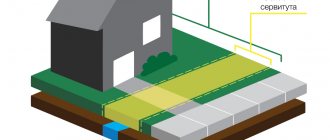
Land plots have established boundaries on cadastral plans. But the fact is that a separate land plot indicated on the cadastral plan may have several owners, and the plot itself in such cases is in common shared ownership.
It should be understood that shared ownership is the concept of ideal property, not real property. That is, each of the co-owners does not own specific land on which they can build a house, equip a greenhouse and erect a fence with a gate, but some abstract figure - 1/2, 1/3, 1/12 and so on.
If desired and, most importantly, if it is possible to allocate a share in kind, the owner can initiate the procedure for allocating shares. This is a big topic that also involves issues of litigation.
However, if the remaining co-owners agree to the division of shares and the cadastral service believes that division of the plot is possible, then the consent of the co-owners will be sufficient to obtain a certificate of ownership of a specific plot of land with established boundaries.
During the negotiation process, the co-owners, with the participation of a cadastral engineer, come to an agreement regarding the establishment of the boundary between their plots. This agreement is secured through the act of agreeing on boundaries.
Subsequently, on the basis of this act, the cadastral engineer will make appropriate changes to the territorial cadastral plans. You can find out more about the procedure for establishing plot boundaries in the corresponding material on our website.
What documents are needed for land surveying?
We have already said that land surveying is carried out by organizations that have a license to carry out geodetic and land management work. Naturally, an agreement will need to be concluded with such an organization. A sample survey agreement is available at roscomland.ru.
In addition, you will need to write an application for land surveying. Look at a sample agreement at edem-city.ru.
For the survey itself, you will need a small package of documents:
- Passport (and its copy) for citizens or statutory documents if the customer is a legal entity. If you want to entrust the entire process to another person, then you need to issue a power of attorney for land surveying; a sample is available at obrazec.org.
- Certificate of registration of ownership of the land plot (if any).
- Documents of title (sale and purchase agreement, certificate of inheritance, resolution on the provision of land, court decision, etc.).
- Copying to the site . This document is a copy made from the master plan of your settlement
.
The part of the general plan that shows your site and those adjacent to it is copied
. You can obtain and certify a copy from the architectural department of your local municipality. - Cadastral passport of the plot . This document reflects all the information contained in the State Real Estate Cadastre regarding your land plot
. You can order a passport at the local Rosreestr office or at the MFC. - Cadastral plan of the territory . This is a plan of the entire cadastral quarter within which your land plot is located
. You can also order the document from Rosreestr.
This list is far from final and may vary depending on some of the nuances of your specific situation. In some cases, citizens are asked to provide an extract from the household register, for example, or a resolution indicating that the territory belongs to a certain category of land.
However, collecting documents is not always the responsibility of the customer. You can entrust these efforts to a trusted person or cadastral engineer, provided that the power of attorney is issued in his name.
The approval act must be attached to the boundary plan.
Where can I get a land survey plan? The result of all boundary work will be the preparation of a boundary plan, which will reflect complete information about the size, location and boundaries of the site. All you have to do is pick up the survey plan from a representative of the geodetic company whose services you used.
The entire procedure for carrying out land surveying requires not only accuracy and attentiveness on the part of all participants in the process, but also requires legal literacy from the customer and the performer of the work.
Any deviation from the norms of current legislation will inevitably cause legal disputes in the future. Therefore, be vigilant, pay attention to every little detail, and protect yourself from possible cadastral errors.
Remember that only registration of the boundary plan with the Rosreestr authorities is evidence of the legality of all work carried out.
For additional information on this issue, please refer to the “Landing” section at this link.
Free legal support by phone:
Moscow and Moscow region (toll-free call)
St. Petersburg and Leningrad region
Attention! Due to recent changes in legislation, the legal information in this article may be out of date!
Our lawyer will advise you free of charge.
_________________________________ (indicate participants in shared ownership) address _________________________________
from ______________________________ (full name of cadastral engineer) address __________________________, telephone _________, fax ________, email address _________
NOTICE of the need to approve the land surveying project
Due to the need to coordinate the land surveying project and on the basis of clause 10 of Art. 13.1 of the Federal Law of July 24, 2002 N 101-FZ “On the turnover of agricultural land” I inform you as follows:
1. Customer of work on the preparation of land surveying projects: _________________________; location address: _________________________; contact number: _______________.
2. Information about the cadastral engineer who prepared the land surveying project: _________________________; qualification certificate N __________; location address: _________________________.
E-mail address: _______________; contact number: _______________.
3. Cadastral number of the original land plot ______________.
Site location: _______________________________________.
4. The procedure for familiarizing yourself with the land surveying project: ___________________________________.
Land surveying projects can be found at: _________________________ from _____ hours _____ minutes to _____ hours _____ minutes.
5. Justified objections regarding the size and location of the boundaries of the land plot allocated on account of the land share can be sent within _____ days from the date of receipt of this notice to the address: _________________________.
"__"___________ ____ G.
_______________________ (signature)
_________________________________ (indicate participants in shared ownership) address _________________________________
from ______________________________ (full name of cadastral engineer) address __________________________, telephone _________, fax ________, email address _________
NOTICE of the need to approve the land surveying project
Due to the need to coordinate the land surveying project and on the basis of clause 10 of Art. 13.1 of the Federal Law of July 24, 2002 N 101-FZ “On the turnover of agricultural land” I inform you as follows:
1. Customer of work on the preparation of land surveying projects: _________________________; location address: _________________________; contact number: _______________.
2. Information about the cadastral engineer who prepared the land surveying project: _________________________; qualification certificate N __________; location address: _________________________.
E-mail address: _______________; contact number: _______________.
3. Cadastral number of the original land plot ______________.
Site location: _______________________________________.
4. The procedure for familiarizing yourself with the land surveying project: ___________________________________.
Land surveying projects can be found at: _________________________ from _____ hours _____ minutes to _____ hours _____ minutes.
5. Justified objections regarding the size and location of the boundaries of the land plot allocated on account of the land share can be sent within _____ days from the date of receipt of this notice to the address: _________________________.
“__”___________ ____ _______________________ (signature)
Sample notice of approval of land surveying project
Notice of the need to approve a land surveying project.
Cadastral engineer Semenov Igor Vladimirovich (qualification certificate of cadastral engineer No. 16-11-745; Republic of Tatarstan, 420000, Naberezhnye Chelny, st.
.
Karchagina, 17, office 10; e-mail: ; contact telephone number) a project has been prepared for surveying land plots allocated on account of the land share of Vasily Ilyich Smirnov from a land plot with cadastral number 16:15:000000:1, located at the address: Republic of Tatarstan, Tukavesky municipal district, Betkinskoye rural settlement. The customer of the work is Alexander Ilyich Agafonov (Republic of Tatarstan, Naberezhny, Moskovsky St.
,
189, apt. 45, tel
.
519-20-20).
The survey project can be viewed daily from 9.00 to 18.30 at the address :
Naberezhnye Chelny, st
. Mira, 51, office 109.
Justified objections regarding the size and location of the boundaries of the land plot allocated on account of the land share are accepted in writing within thirty days from the date of publication of this notice. *
*Clause 8, Clause 11 of Article 13.1 of the Federal Law of July 24, 2002 No. 101-FZ “On the turnover of agricultural land”
In life you should strive not to overtake others, but yourself.M. Babcock
- home
- Documents and agreements
On this page you can see and download a standard sample application for boundary work, which you will need to draw up and submit with all the relevant documents to the land management geodetic organization.
This document is arbitrary and all points in it are advisory in nature, but in most cases the sample of our application will be correct.
Procedure
The act of approval may be significantly distant in time from the moment of initiation of the procedure for establishing boundaries.
The fact is that boundaries cannot be established only at the request of land owners. Cadastral authorities play a significant role in the division procedure. They determine the possibility of dividing the site and establishing boundaries.
Once the cadastral engineer determines that there are no obstacles, he begins the preparatory procedure. At least a month before the boundaries are established, he notifies the co-owners of the date for which the final procedure is scheduled.
When dividing and establishing the boundaries of a land plot, the cadastral engineer takes all the necessary measurements and sets special boundary markers on which he makes marks about the day they were established.
The entire procedure is reflected in the approval act. In it, the owners record their agreement with the method of establishing and defining the boundaries.
Act on coordination of boundaries with neighbors of a land plot: sample, form download
Since this principle applies only to the real rights of plot owners, it is not pre-established for neighbors who own their plots on another legal basis. For example, people who are tenants of land do not have the rights to sign a document agreeing on the boundaries of land plots with neighboring owners; certification must only take place under the influence of the legal owner, who will be the municipality.
When is it not required?
Innovations concern the Federal Law on the State Cadastre. Article No. 39 states that the determination of boundaries between neighboring properties must be carried out without fail with the preparation of a proper act and signatures from all participants in this process.
- The location of the meeting is chosen to be the locality to which the territory in question belongs, or the nearest city. At the discretion of the parties, as agreed through the cadastral engineer, another meeting place for the parties is allowed.
- To participate in the meeting, everyone is given a written notice with mandatory notification of receipt. Transmission of information via email is permitted. For notification, data on land users and owners from the State Property Committee is used. The deadline for sending the notification is no later than 30 days before the appointed date.
- Within 15 days from the date of delivery, interested citizens have the right to object to the circumstances of the event. In some cases, public notification of an upcoming meeting of owners is possible:
According to the law, the land fund, consisting of many plots registered in the cadastral register, requires precise recording of the boundaries of each plot. This measure allows controlling structures and organizations to keep strict records of the entire fund, which includes the most diverse objects in purpose, form, and type.
Approval procedure
The presence of clear boundaries registered by supervisory organizations will make it possible to establish the legality or unfoundedness of the property claims of the parties, owners of adjacent lands, and government departments.
The notice is drawn up according to a regulated structure; the mandatory information, in addition to information about the customer and the contractor, includes information about where and how you can familiarize yourself with the preliminary drawings of the project, on the basis of which the act is drawn up.
Drawing up an act
As part of this article, we have developed and made available for download a standard sample of acts of the type in question. After a little individualization, the sample will be suitable for use in the procedure for approving the boundaries of a land plot.
In general, the act of coordinating boundaries includes a standard set of sequentially located structural elements, namely:
- Title of the document;
- date and place of drawing up the act;
- cadastral information about the site (sites) between which a boundary is established - area, settlement, other characteristics;
- information about the owners of the plot(s), including the cadastral engineer;
- information about the persons involved in drawing up the act;
- information about markers installed at the boundaries of the site;
- expressing the consent of the owners with the order and method of marking boundaries;
- information about the absence of disagreements between the owners;
- signatures of persons involved in marking boundaries.
If disagreements arise between the owners, their essence will need to be included in the act. In the future, the act with these marks may become one of the materials in a civil case in a claim to challenge the boundaries of a land plot.
An act is drawn up in the number of copies corresponding to the number of parties interested in the act.
Coordination of land boundaries with neighbors under the new law
The publication and notification contain information about the engineer conducting the process, the date and time, the location of the collection, and the location of land plots with cadastral numbers. If, after the announcement was issued, people did not appear at the meeting, then their signatures are not required. They were notified and did not come, which means they approved the changes.
We recommend reading: How to quickly check out of an apartment
A claim is filed to resolve the boundary dispute, accompanied by a written refusal from the defendant to coordinate the boundaries. The main thing is to draw up a claim according to its structure, or the judge may refuse to consider it. It sets out a request to establish the boundaries of land surveying, according to geozodic information.
The act of approving the boundaries of the location of the land plot
Coordination of site boundaries is a serious procedure; it requires great care and awareness. Stakeholders must monitor the actions of the engineer and monitor compliance with all legal regulations for the preparation of the approval act.
Obtaining signatures can be done individually or through a meeting. The parties must be notified that it is necessary to sign the act (or leave a written refusal to sign it). Notice must be sent at least 30 days before the meeting.