Topographic survey of a land plot is actually a whole complex of engineering and geodetic work, the purpose of which is to create a topographic map or, in other words, a plan of a specific area, in paper or digital form. Since this procedure is in demand to this day, questions remain about when it is necessary to resort to it, and who directly provides topographic survey services. Let's look at these questions in more detail.
How to Restore the Boundary Plan of a Land Plot
Cadastral registration
- actions of the authorized body (Federal Service for State Registration, Cadastre and Cartography, formerly Rosnedvizhimost) to enter into the State Real Estate Cadastre (GKN) information about real estate that confirms its existence with characteristics that allow such property to be defined as an individually defined thing, or confirm the termination of the existence of such real estate, as well as other information about real estate provided by law.
In accordance with Federal Law dated July 24, 2007 No. 221-FZ “On the State Real Estate Cadastre” (hereinafter referred to as the Law), the boundary plan is a document containing information about the land plot necessary for cadastral registration (Articles 22 and 38). Grounds for performing cadastral work
What to do if you lose a document
Documents can get lost for various reasons, such as moving, constant contact with different authorities when registering property, etc. But if this happens, it must be restored without fail.
Due to the possibility of restoring documents for real estate, the state has certain regulations. First of all, the interested person will be required to submit an application to the register. But here, too, certain nuances must be taken into account. For example, if the owner submits a certificate showing a brief description of the land plot, he will be able to continue the passport restoration procedure.
If the territorial allotment has been registered, you can obtain copies from the register that were submitted during the registration of real estate. In order for them to gain legal force, you will need to contact a notary office, and a specialist will certify them with his seal.
The process can become significantly more complicated if documents that were issued before 1999 are lost. Therefore, it is better to immediately use legal assistance, it will be faster. And it is also necessary to remember that each certificate has a certain period of validity. Here it is important to collect them as quickly as possible and submit them to the registration authority. In case of delay, it will have to be restored and paid for again.
Here is an approximate scheme of actions: first you need to order an extract from the Unified State Register, wait a few days until it is prepared. Then, for a copy of the papers, contact the regional archive, a branch of the Federal State Budgetary Institution, or an inventory center. But no matter how much time it takes to restore a passport to a land plot if it is lost , this is a mandatory procedure. Without it, it is impossible to sell, exchange, rent and perform other manipulations. With a notarized power of attorney, the interests of the owner can be represented by a trustee and even be present in court on his behalf. But this is a last resort if it is not possible to obtain a duplicate through authorized structures.
Land survey plan
- In the event that inconsistencies are identified with the information provided about the established boundaries and data from the Unified State Register of Real Estate.
- In the event that the information provided differs from the data from the Unified State Register of Real Estate on the location of forest parks, forest districts, settlements, territorial zones, and boundaries of municipalities. If there really are such discrepancies, then a state cadastral registration of the land will have to be carried out.
- In the case when work was carried out to clarify or redistribute the location of boundaries during the surveying of a particular piece of land.
- In cases where it is necessary to supplement cadastral activities with this or that information. But this data is supplemented only by decision of the cadastral engineer.
- All information about land ownership is collected. After which all information is analyzed.
- At this stage, the process of notifying the organizations and rights of those directly affected by this case takes place. As a result of this, a process of boundary coordination occurs. If necessary, other issues are resolved.
- A mandatory process of geodetic work is taking place.
- Based on the results provided by the cadastral engineer, an objective and complete assessment of the situation is carried out.
- A boundary plan is being prepared.
- An already prepared inter-plan and the entire folder of documents are provided to the cadastral chamber. After this, time is expected to register this or that plot of land with the cadastral register. As a result of this, a passport (cadastral) is issued.
- Issuance of passport.
- A cadastral extract is also provided. It necessarily contains verified coordinates of the boundaries of a particular territory that is undergoing a land surveying operation.
- Finally, the boundary plan is prepared in the GPZU, where the signature and seal from the cadastral engineer is carried out. Only the one who draws up and prepares this plan.
Interesting: When building a house, the distance to the fence
Types of topographic plans
There are several ways to divide topoplans. One of the signs on the basis of which they are divided is the nature of the information that is displayed on it - they can be:
- Basic, when all information on the site is reflected;
- Specialized. In such a situation, only the data that the customer needs in connection with the specific purpose of using the allotment is indicated.
In addition, plans can be divided according to the scale of display of objects on them. The main types of plans that are most widely used are:
- Geobase;
- Horizontal survey plan;
- Tree plan.
Geobase
The geobase is one topographic plan of the area of interest or several of its displays .
Moreover, each of a certain number of documents can be of a different scale.
In most cases, they are used to create reconstruction plans, technical projects, master plans of the construction area, various intermediate and working drawings.
The geobase is characterized by the fact that it is somewhat different from standard documents in that it displays objects not only those located on the surface of the earth, but also those that pass under a certain layer of the earth.
Horizontal plan
This type of topoplan is defined as one that allows you to create a contour plan of the area . The shooting is carried out in areas that are already built-up, and they contain a large number of different objects with various shapes and contours.
This survey is most often carried out in populated areas, areas located within the plain or those that include railway junctions.
In addition, this type of plan is often used when establishing the boundaries of lands, calculating their size and location relative to each other. A characteristic feature of such surveys is the complete lack of information about the topography of the site .
Wooden
Such a document refers to the most detailed way of displaying what is located on a piece of land. This plan is being implemented on a larger scale than all others - 1:100 – 1:500.
These types of plans display:
- Detailed terrain;
- Existing vegetation (trees);
- Elements of hydrography;
- Located properties;
- Changes that have occurred in the earth's crust that are anthropogenic in nature.
This type of plan has found the greatest application when carrying out work on landscaping areas and designing arboretums under construction.
How to restore the boundary plan of a land plot
Any operations with land plots require that their boundaries be officially recorded and documented. To do this, land surveying is carried out - a set of geodetic measures that allows you to link data about the site with a map of the area, draw up a survey plan, and then document the results obtained. The work is carried out by geodetic companies that have received the appropriate engineering and geodetic license. As a result of their implementation, data on the area and boundaries of the site are determined, fixed or restored.
It is important to note that land surveying in Moscow, as in other settlements, is a very important procedure. Without the necessary documentation confirming the boundaries of a certain plot, not a single transaction related to land can be carried out. Land surveying also provides the land owner with a guarantee that the buildings he has built will not be demolished, because he will have a conclusion on land surveying in his hands.
How it is done
Topographic surveys can be carried out both from satellites and on the ground.
For everyday purposes, satellite imagery intended solely for recording large areas is not used. In this case, to order a site plan, the interested person will have to contact an accredited organization.
Geodesy of a plot of land on the ground can be carried out exclusively by an engineer-surveyor, using special equipment, namely:
- navigator with GPS system;
- tacheometer necessary for measuring angles and distances;
- aircraft allowing for aerial photography.
Thus, you will not be able to carry out the procedure yourself.
We remind you that even if you thoroughly study all the data that is in the public domain, this will not replace the experience of professional lawyers! To get a detailed free consultation and resolve your issue as reliably as possible, you can contact specialists through the online form .
Let's take a closer look at what a topographic survey of a land plot looks like.
The procedure takes place in three stages.
- At the preparatory stage, an agreement on topographic surveying is concluded between the parties; it must indicate the type of survey and the timing of the event. In addition, if necessary, the terms of reference for surveyors and estimates are approved, information is requested from Rosreestr, and permitting documentation is drawn up at the local urban planning department. If the customer of the work has any cartographic materials on hand, they should be transferred to the surveyor for subsequent analysis. These include cadastral and situational maps, diagrams of engineering units, etc.
- Directly a complex of works on the ground. When carrying out a topographic survey, a so-called geodetic network is created, special signs are installed on the ground to measure the coordinates of the study area, and underground utilities are identified and examined.
- At the third stage, the information obtained during field activities is processed and the necessary calculations are made. The exact boundaries of the area are determined, and the location of all above-ground and underground objects existing within the site at the time of the work is noted, with reference to coordinates, on a predetermined scale. As a result of this analysis, a topographic plan is drawn up, which is actually a model of the land plot, in the number of copies required by the customer. Information can be provided not only graphically, but also digitally. After the procedure, a technical report must be drawn up.
What to do after land surveying and what the survey document looks like
Therefore, before the appointed time, all landowners need to carry out this procedure, although previously the law was not obligatory to do this. However, the Russian authorities are thinking about expanding the tax base through land properties and reducing the number of unregistered plots of land.
In a situation where a land plot has already been taken into account, but its boundaries are unclear and a dispute has arisen with neighbors regarding how much land belongs to whom, the issued boundary plan must also be submitted to Rosreestr, so that this body officially makes changes about the updated boundaries in the Unified State Register of Real Estate (USRN). GKN).
Land surveying
According to the current Federal Law, a boundary plan is documentation that was drawn up on the basis of a cadastral plan for a specific plot of land or a cadastral extract about a certain territory. The cadastral extract contains all the necessary data for inclusion in the state real estate cadastre. This document also contains specific information about one/several plots of land being formed or about its part/parts, or new data about one/several plots of land.
A boundary plan will allow you to display the exact and documented boundaries of your property on the ground. A plot of land that does not have precise boundaries on the ground cannot be graphically displayed on a map. Therefore, if you do not have a boundary plan, then you will not be able to become the owner of a cadastral passport for a land plot . It is issued by the Rosreestr branch in Tula and the Tula region, in Kaluga and the Kazhu region. Cadastral passport , which is required when registering property rights, selling, buying, donating, inheriting and any other transactions, is an important document for the owner of the territory. If there is no land surveying, then any action of the owner with the land plot will be illegal.
We recommend reading: Calculation of compensation upon dismissal after 11 months
Boundary plan of a land plot in Chekhov and Chekhov district
In order to prepare a boundary plan, please contact. Land surveying is a land management procedure, and only cadastral engineers with permission have the right to do it. Our specialists have licenses and SRO approvals, we guarantee the results of our work. View our licenses below .
- To register a new land plot
- Making changes to the characteristics of land entered into the cadastre
- Making any transactions
- Dividing a site into several parts
- Allocation of shares from shared ownership
- Combining several areas into one
- Clarification of land boundaries
- Redistribution of land
- Restoring borders in case of boundary disputes between neighbors
- Cadastral error corrections
Interesting: In Bashkiria, what do they give for a third child?
The survey has been carried out - after that we move on to registering the land plot
So, in order to successfully register a land plot according to all the rules, you need to decide on the following:
- The memory was taken into account earlier;
- or it is not registered in the cadastral register.
In the first case, the entered information will require careful checking: if the information about the boundaries is different (technical errors that led to the overlap or displacement of boundaries, “crookedly” entered records) - you need to go through the procedure for making changes to the cadastral registration information. For this:
- we turn to a competent cadastral engineer, whose work will not require subsequent adjustments and corrections (the Land Lawyer cooperates only with such specialists);
- We are preparing an application to Rosreestr to make appropriate changes;
- We are attaching a new boundary plan (we are preparing an electronic version).
In the second case, we do the same thing, only in the application we now ask that the object be registered in the cadastral register. The procedure for registering a land plot after surveying is quite clear. But there are always a few “buts”:
- We do not forget that although the boundary plan has no time limits, it must comply with the current legislation, but it does not stand still;
- if the deal is on fire, and the documents for the plot are not in order, you can register the transfer of rights and put them on the cadastral register at the same time, but everything must be done accurately and without errors;
- We remember that saving on cadastral work is not a benefit, but the basis of future problems, ranging from disputes with neighbors to difficulties with construction registration.
Procedure for drawing up a land plot plan
Land surveying as a land management procedure is a whole complex of geodetic and land management work carried out with the aim of establishing, restoring and (or) securing land boundaries on the ground and determining the location and area of land plots.
In addition, the boundaries of a plot of land are established and fixed in the boundary plan directly at the request of the owners, if documentation certifying their rights to the corresponding plot of land was issued without the necessary establishment and fixation of the boundaries of the land plot on the ground.
How to restore documents to a site
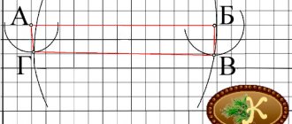
Important Persons whose interests may be affected in this situation are neighbors who own their plots on the basis of legal ownership, perpetual use, lease or inherited ownership. Agreement takes place in the form of a meeting or separately with each owner. After receiving the notification, interested parties must express their consent by signing the document, or write a reasoned refusal. There can be two scenarios for the development of events:
- The neighbors agree with the declared boundaries and coordinates. If the act is signed by all owners of neighboring plots or their legal representatives, it is agreed upon.
Land surveying in the Priozersky region: sequence and purpose
Currently, many owned land plots do not have a cadastral plan and, accordingly, defined boundaries. This gives rise not only to land disputes, but also to problems for new owners. Until January 1, 2020, it is allowed to make any transactions with land, even without marks of its boundaries. After this date, carrying out any types of transactions without a cadastral passport will become impossible. You should take care in a timely manner about land surveying and proper execution of title documents for your land, residential building or other real estate.
Land surveying in the Priozersky district, which includes conducting a cadastral survey and accurately establishing the coordinates of all turning points on a land plot that define its boundaries, is necessary for all real estate owners. This procedure is carried out by land management organizations that have received permission for this type of activity and have certified surveyors on their staff.
Stages and timing
To carry out the work, you must contact a licensed company and clarify the procedure and timing of the service. You need to take with you:
- passport;
- land ownership certificate;
- an agreement that reflects the method of acquiring the site (for example, purchase and sale);
- cadastral plan and other technical documentation - if available.
What documents are issued after land surveying?
- At the bottom, select the tab with electronic services and services. Go to the section on state registration of rights;
- in the list that appears, select the tab containing the inscription about actions by entries in the register of rights to real estate objects of the Unified State Register of Real Estate;
- check the box indicating changes to the record and go to the details of the request by clicking the appropriate button;
- fill out the application form;
- Attach documentation to it in electronic form and submit for review.
The above authorities have sample applications that you can use. If you are preparing a document in advance, bring it with you and provide it along with the original documents. After verification, the employee of the competent authority leaves copies of them.
Boundary plan of the land plot: requirements, preparation, preparation
There are several reasons for preparing this document. The main one is the division of one original territory into several fragments, in particular, when one enterprise intends to build several smaller ones around the main building and needs to separate each of them.
This document usually contains information about the real estate located on a particular plot of land. Materials from the plan are sent to the state real estate register, so they must be as complete and correct as possible. The document also contains information about the existing land area, plots, parts thereof and smaller units. Also, data related to changes in land plots and other formations is entered into the boundary plan.
Interesting: Who Has the Right to a Tax Deduction When Buying an Apartment
How long is the boundary plan valid and how much does it cost to get it?
- when changing location;
- when the area changes (then the boundaries automatically change);
- if the land plot was divided into several smaller pieces of land;
- when the merger of the land plot in question with the neighboring one took place. As a result, they formed a new area, the boundaries of which changed, etc.
For individuals and organizations, prices are also different: for citizens, a boundary plan will cost several times less. In addition, all prices for this type of work are regulated at the state level, so geodetic companies strictly adhere to them and do not have the right to set prices above the maximum.
We recommend reading: Queue for a plot of land
Restoration of land
The boundaries of land plots are indicated by special land surveying signs. These signs do not last forever: they can be destroyed by neighbors or random hooligans, they can disappear under the wheels of an excavator or disappear underground due to excavation work nearby. Without clearly defined boundaries, you can’t even put up a fence or build a house, what if this place is already your neighbor’s territory? There is only one way out: to restore the borders of our land.
Land surveying is a labor-intensive and painstaking process. It must be dealt with carefully and with all foresight, since incorrect installation of boundary signs can lead to disputes about the restoration of borders with neighbors or officials. Our geodetic service is ready to get down to business, and here's why you should choose us:
How to restore the boundaries of a land plot and how to file a claim
Until 2013, the issues of determining the boundaries of land units and fixing them on the ground were dealt with by employees of the BTI bodies, and after the introduction of the cadastral registration system, these powers were transferred to cadastral engineers. Currently, the features of establishing the boundaries of an allotment can be defined as follows:
Restoring the boundaries of a land plot is one of the ways to protect the rights of the owner from possible violations by third parties. This procedure can be carried out in court or pre-trial, and the result of the actions will be the entry of information into the boundary plan and the installation of boundary signs on site.
Reasons for receiving
According to the regulations, each plot must be registered with the cadastral register. This procedure could have been performed earlier, without land surveying. Accordingly, undemarcated plots could be transferred from one owner to another.
The legislation does not limit owners' property rights , in accordance with Article 35 of the Constitution of the Russian Federation and Chapter 17 of the Civil Code. This rule created a precedent for the presence of undemarcated plots put up for auction in large quantities.
The purchase of such plots leads to legal consequences in the form of disputes between the owners. In such cases, coordination of the boundary plan of the land plot is very useful. Also, land surveying (see what it is) is required when allocating (cutting) land or reorganizing a site by connecting or dividing.
The listed cases require contacting the geodetic (cadastral) service.
The basis for carrying out land surveying is an application written and submitted by the owner or co-owners - if the land plot is jointly owned. And the basis for obtaining a boundary plan is to carry out topographical and geodetic work.
Application for land surveying.
How to get a land survey plan
- Certificate of ownership of the property, as well as other title documents;
- Extract from the unified state registration database of property rights;
- Applicant's passport;
- Technical documentation from the Bureau of Technical Inventory on the absence or presence of buildings;
- Cadastral plan or extract.
- Collection and analysis of information about the property;
- Notifying owners, interested individuals and organizations whose rights and interests may be affected about the upcoming land survey;
- Coordination of territory boundaries and other controversial issues;
- Geodetic survey of a real estate property;
- Analysis of the cadastral result;
- Drawing up and execution of a boundary plan;
- Submission of documents to the cadastral registration institution;
- Obtaining a cadastral passport, plan and extract on the location of the object;
- Signing the boundary plan and affixing the seal of the responsible engineer.
26 Apr 2020 glavurist 233
Share this post
- Related Posts
- What is needed to formalize a deed of gift for a share in an apartment
- How to find out when my home is included in the capital repair program
- Upon retirement, what payments are due from the pension fund?
- How to order an extract from the Unified State Register from the tax office