PRO new building 7 (499) 703-51-68 (Moscow)
In the search section that appears, you must provide information about either the cadastral number of the plot or the locality where it is located.
We select the area that interests us. Next, in the “Map Management” menu, you need to check the boxes in the “Cadastral value” and “Cadastral value per meter” sections. With regard to purchase and sale transactions, one clarification needs to be made here: the cadastral value is rarely used for such purposes, since it is mainly used to calculate taxes. For this reason, officials tend to overestimate the cadastral value, which creates a situation where the real price of land differs greatly from the value indicated in the cadastre.
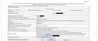
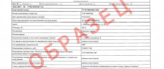
Cadastral plan of the land plot
It is convenient to view the cadastral plan of the land plot on the online cadastral map
The map is posted on the service of Rosreestr, the body carrying out state cadastral registration of real estate. It displays all objects, information about which is included in the State Property Committee. The cadastre is publicly accessible and cadastral map information is provided to an indefinite number of persons free of charge.
The boundaries of the site on this document are presented in schematic form, as well as in a text description.
It is very important to study this document before concluding a purchase and sale transaction. If there is a discrepancy between the plan and reality, the transaction will have to be postponed until it is re-registered.
On a public map you can view the cadastral plan of a land plot, as well as measure its area.
It often happens that the schematic representation of a site on the plan does not have data on its dimensions. In this case, we recommend that you use our service to determine this size yourself.
Valuation of land plot
Qualitative assessment of real estate value
may be needed in different cases.
And it is natural that the assessment of market value
should be carried out by real professionals in their field.
Self- valuation of real estate
most often leads to the fact that it is not possible to set a price that would suit both participants in the process, regardless of whether we are talking about selling or buying.
Naturally, the value of the property
depends on many factors.
And these factors are known to specialists who have been working in this field for many years, doing everything possible to make life as easy as possible for their clients. A high-quality market valuation of real estate
does not take much time, and at the same time, it can significantly simplify the transaction process, ensuring that both parties are satisfied.
Online valuation of land
You can find out the cadastral value of your area, knowing the cadastral number or the exact address using the Internet on a specialized website. You will receive the cost if your territory has already been demarcated and the area has been registered with Rosreestr. But in this case, you will not receive an assessment report or other document confirming the price; to receive an official document, you must send a request and also wait for its execution. If you just decide to find out the preliminary price, then this is an acceptable option for establishing an indicative price.
Do not forget that for registration of purchase or sale transactions, donations and other types of transactions, the assessment report is valid for 6 months. After this time, you will have to contact specialists again.
Calculation of the cost of land
Remoteness from a populated area plays a big role, but here one can argue about whether this is an advantage or a disadvantage. The fact is that each land plot has its own category, which determines its special purpose. And the benefit of the remoteness of the site depends on which category is assigned to the land. For example, if you are selling an industrial zone in the middle of a populated area, then you may have problems with the audience of buyers, since no one wants to pay too high taxes for environmental damage. The same story will happen if you sell a plot of land for a settlement one hundred kilometers from the nearest village.
We recommend reading: Refund of mortgage interest
If you are a person who is not very savvy in matters of land valuation, then you can contact the appropriate company that will provide you with such a service. An expert who specializes in land valuation will come to your land plot, and your task is to ensure that you can advise him as accurately as possible on the availability of functionality. Afterwards, the specialist will make a final verdict on the overall assessment of the property being sold.
How to view the cadastral plan of a territory by cadastral number
You can view the cadastral plan remotely on the public cadastral map of Rosreestr, located at https://pkk5.rosreestr.ru. This service allows you to obtain a wide range of information regarding land plots online absolutely free of charge. It contains cadastral information that is publicly available to all interested parties. Some information is not available here for obvious reasons, in particular the owner’s full name and passport details.
In order to find the area of interest and see its cadastral plan, you can use two search options:
- by cadastral number;
- to the exact address of the land plot.
You can find out the cadastral number from documents confirming ownership of a land plot: a certificate of ownership or an extract from the Unified State Register of Real Estate. It is also included in cadastral passports for the site, issued earlier.
The algorithm for obtaining information about the cadastral plan of the site will be as follows:
- You need to open the public cadastral map located at https://pkk5.rosreestr.ru. The map is available to all interested parties and is accessible to everyone.
- In the left corner there is a search line where you need to enter the cadastral number. The cadastral number has the following format: XX:XX:XXXXXXXX:XX. Please note that the search must be carried out by the “Plots” category (usually it is set by default).
- If the cadastral number was registered correctly, then a card of the land plot and its schematic image will open. The selected area will be highlighted in yellow, its borders will be highlighted with a red line. The scale of the object can be adjusted: when it is reduced, the user will have access to the surroundings of the site and its closest neighbors. If desired, the scale can also be increased.
- The card of each plot contains information indicating the primary cadastral registration data: cadastral number of the plot and quarter, its area, cadastral value, form of ownership (private or public), full name of the cadastral engineer who was responsible for land surveying, date of cadastral registration. The map also provides access to various services online, in particular, to obtain an extract from the register or clarify information about a property.
- To obtain a cadastral plan of the land plot, you need to click on the “Land Planning Plan” tab. There is also a tab nearby that allows you to see the plan of the cadastral quarter.
The site plan will look like this:
Market value of land
Many law firms do not limit themselves to providing legal assistance to clients. They offer examination and valuation services. It is advisable to contact such offices when you need not only to find out the cost of the property, but also to receive legal assistance. For example, the court requires the division of property with your ex-spouse, but you do not agree with his assessment.
After all the documents are ready, enter into an agreement and pay for the service. Be sure to read the terms of the contract carefully. It must specify the appraiser's responsibility for problems arising through his fault due to an incorrect assessment of the market value of the land plot.
How to evaluate a land plot?
To obtain a cadastral valuation, you must contact Rosreestr. Market valuations are carried out by appraisers registered in the unified state register and complying with the requirements of current legislation. An appraisal is a legal action, after which you will be given a report confirming the market value of your property. This document will be voluminous and may contain up to 80 sheets, since it will contain information on the basis of which the final price is determined. In addition, the assessment is carried out using several methods. In the appendix to the report, you must include all copies of the documents that were used in the assessment process. Documents characterizing the territory, expert opinions, reference materials on the basis of which conclusions are drawn. The report must also contain certificates of registration of the appraiser, liability insurance contracts, and diplomas confirming the qualifications of the appraiser.
In the market for the provision of services, appraiser services are represented by many companies and individuals, which is also permitted by current legislation. Be careful when concluding an agreement, read the reviews of those clients who have already used the services of this company, try to contact trusted specialists from whom you or your friends have already ordered services. The qualifications and responsibilities of the appraiser can have a significant impact on the value of your transaction.
Online land valuation calculator
The transfer of funds will take 10 days. PRO new building 7 (499) 703-51-68 (Moscow) PRO new building (Moscow) Primary Menu To manage resources productively, you need to know how much they cost. Land is also an economic resource, so it is also subject to valuation and accounting.
Evaluate a plot of land online with a free calculator. A mortgage for an apartment is no less important a document than the loan agreement itself. Why is it needed, how to formalize it correctly, what to do if the mortgage is lost - read about it in our The topic of forced eviction from an apartment is relevant at all times. Who, where and why can they be kicked out by law? To be fully prepared or, on the contrary, to get rid of worries.
How to find an allotment plan online?
Let's look at the example of a map posted on the Rosreestr website:
- We go to the Internet resource https://rosreestr.ru/.
- Scroll to the inscription “Electronic services and services”.
- Click “Go to section”.
- A tab will open with .
- In the form you need to indicate the address of the object.
- Click “Generate request”.
- After this, you will be given information about the requested object, if it is present on the map.
If you want to look at the map and find the object yourself, then:
- Go to https://pkk5.rosreestr.ru.
- We see a large map of the Russian Federation. At the top left we see a column with different icons; to start the search you need to select the icon with a magnifying glass on it.
- Next to it there is a window in which “Land” is indicated, scroll through and find “Borders”.
- After entering the address, a tab will open with the necessary information about the land plot.
Determining the market value of a land plot
- during the period of registration of mortgage lending for individuals;
- during the period of making a decision on privatization, leasing, or during the period of transfer of a property to another person directly by proxy;
- in the event that the property is provided as collateral;
- carried out during the period when the parties disagree on the total cost, when the nationalization procedure is already underway;
- carried out during the formation of marriage contracts, if the spouses have the necessary information about the objects;
- during the period of confiscation of property from citizens;
- during the period of calculations that will be carried out to verify the accuracy of paid property taxes.
- Initially, it is necessary to make an analysis of the cost of similar objects, and then a check is made to verify the reliability of the established price, whether it was forced in any way.
- For comparison purposes, it is necessary to take at least 3–5 plots of land.
- Taking into account all coefficients without exception, the cost should be derived.
We recommend reading: Tax on major repairs
How to find out the market value of a land plot
The problem of reliably calculating the value of a land plot can be solved by contacting professional appraisers. In the Russian Federation, the activities of professional appraisers are certified and regulated by law, and the appraisal results are recognized as an official document certifying the market value of the land plot as of the appraisal date. After concluding an agreement, the procedure for assessing the market value of a land plot by an appraiser will include the following steps:
The sales comparison method involves an analysis of recent transactions for the sale of land plots that are similar or as similar as possible to the plot being sold. To clarify the market value in this case, a system of discounts and markups is used to determine the cost of a specific object, taking into account existing differences (both for the better and for the worse) from objects whose selling price is known.
How to find out the boundaries of a land plot by cadastral number
As previously noted, the fastest and least expensive way to determine the boundaries of a land plot by cadastral number will be various online services.
Instructions
There are several sites on the Internet that allow you to obtain the necessary information (for example, https://maps.rosreestr.ru/PortalOnline/).
This site was created in the form of a map on which land plots are marked. In order to find the one you need, you just need to know its cadastral number. At the top left of the page there is a search box in which this number should be entered. After entering the necessary information, the map will be zoomed to the requested area, all the necessary coordinates, as well as the boundaries of the area, will be available for study.
The cadastral number of the land plot can be found in the cadastral passport issued for this property.
Market value of land plots
Russian legislation provides not only cadastral value, but also regulatory and market value. The normative one is applied in cases where the cadastral definition has not been made. It is calculated in a number of cases that are prescribed by law: when receiving bank loans against land collateral, purchasing municipal and state lands, and in other cases. Calculation of the cost of a land plot in this case is usually determined as a 200-fold land tax rate per square meter of land area, calculated on the basis of the intended purpose, taking into account increasing factors and not taking into account tax benefits.
The market value of land plots is directly dependent on factors such as: location of the territories; accessibility for vehicles; the presence of communications, as well as their quantitative and qualitative composition. In addition, it is necessary to take into account the data of geodetic and geotechnical research, the importance of which is quite large, especially when planning construction work on the site.
Land assessments
Valuation is divided into cadastral and market. What is their fundamental difference?
The determination of the cadastral value is formal and includes the location, intended purpose and category to which the object belongs and is established by government agencies. Based on it, the land tax payable is calculated. The market value is determined very individually. In such an assessment, a variety of factors are important: air purity, the presence of a natural reservoir, transport accessibility, popularity in the market, the possibility of housing construction, the availability of electrical and gas networks, and others. In most cases, the market value exceeds the cadastral value. The market value determines the approximate price of your plot if you decide to sell it, divide the property during a divorce, or set it as collateral when receiving a loan. Land organizations are included in the authorized capital, and their value is a certain part. For agricultural enterprises, agricultural land is a significant share of the main property.
Market value of a land plot: determination standards and differences from the cadastral price
When calculating the market value, a variety of indicators are taken into account, including the availability of communications, the distance of the land from a populated area and the quality of the site itself. For example, a plot located close to a large city or other populated area, which has its own communications (electricity, gas), will be valued better than land without specially installed amenities.
Since calculating the exact market value is a complex and time-consuming process, it is better to turn to professionals for this. Such services may be needed if a person wants to challenge the cadastral value or sell the land at a clearly verified market price. Of course, there is a clear procedure for assessing the market value of a plot, which is worth discussing separately.


