Free legal consultation by phone:
8
Until 2020, any use of land without documents for its use was regarded by law as unauthorized seizure. The problem led to the appearance of a separate chapter in the code concerning the “cutting” and redistribution of land plots.
The specifics of the procedure for allotment and the cost of increasing a land plot depend on the departmental affiliation of the territory with federal, municipal bodies or federal subjects that adopt the relevant acts.
Who can benefit from redistribution?
In most cases, this procedure applies to citizens who own a plot for individual housing construction (IHC), personal subsidiary farming (LPH), gardening, dacha farming or vegetable gardening.
Land legislation also provides grounds for redistribution for the development of built-up areas in order to bring the land into compliance with the approved land surveying project.
They also use this opportunity to build facilities, seizing land for state or municipal needs.
How many acres can be added to a plot of land: registration procedure
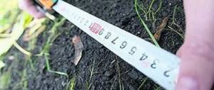
But this rule applies if the annexed territory in its area does not exceed 10% of the land to which it is annexed. If the amount exceeds 10%, the citizen will have to pay the full cadastral value of the land.
- First you need to find out the ownership of the land that is located next door. The law prohibits cutting off territory that belongs to legal entities and state-owned enterprises. That is, it must belong to the municipality. This can be done by submitting a written request to the geocadastre or studying an online map of land plots. In addition, there are situations when the territory belongs to another owner (individual) or is in his use.
- Next, you need to obtain an extract from the special unified state register for this plot (it must indicate that the land is the property of the municipality). If such information is not in the register, the citizen must contact the geocadastre service and municipal authorities to obtain permission to conduct land surveying and prepare cadastral documentation (site passports).
- The next step is to prepare title documents for your real estate (land plot). This could be a purchase or sale, an inheritance, or a gift. It is necessary to remember that those citizens who own the plot and not use it have the right to make an extension.
- After this, the citizen is obliged to find a project for surveying the territory on which his land and the adjacent plot are located. There are situations in which such documentation is not completed. There is no need to be upset, there is a way out. You need to obtain a special document, namely a diagram of the location of the future plot of land on the cadastral plan of the given territory. This diagram or plan must be included in the geocadastre if the territory is visible on the online cadastral map of the settlement.
- After collecting all these documents, the citizen is obliged to write a special application, to which he attaches all the above documents to the municipal body that deals with land registration.
- Attach a receipt for payment of government services for paperwork.
- After this, cadastral documentation is prepared and land surveying is carried out to determine the boundaries of the cut-off.
- The end of the registration of the addition is the signing of a special agreement with the authorized body of the municipality, which gives the citizen the right to register the land as his property. Based on it, the land will be registered in the state register.
Interesting read: Are Red Lines Visible on the Cadastral Map
The cost of adding land to the main plot in 2020
Redistribution and addition of land is a paid service. The fee is set differently for different lands. For federal lands, lands of constituent entities of the Russian Federation, municipal ones - the cost of “addition” of land to a site is established accordingly by the Government of the Russian Federation, the state authority of the subject, and local government body.
For example, for federal lands, the fee is 15% of the cadastral value. In the Leningrad region - at the full cadastral value.
In St. Petersburg there are correction factors. Owners of an individual residential building, a country house or a plot for gardening can buy the “cut” area at half the price.
In other cases, the “addition” of the land plot to the main one is carried out at the cadastral value.
Calculation example. The formula is the same everywhere. You know the area of your land plot and its cadastral value (you can find information on the Public Cadastral Map). Divide the area of the plot by the cadastral value - you get the price per 1 sq.m. Do you want to add 500 sq.m. to the plot? Multiply the “cut” area by the price of 1 sq.m. is the price of redistribution. If you are the owner of individual housing construction, then multiply by the correction factor - by 0.5.
Possible reasons for refusal
However, land owners should understand that redistribution (addition) of land and land plots is not always feasible. To avoid wasting time and money, it is important to know the common reasons for refusal.
The “total” reasons that are specified in the Land Code of the Russian Federation are 23. Before starting work, you should make sure that the frequently encountered grounds for refusal of redistribution are absent.
Limitations include situations such as:
- Impossibility of redistributing land due to being in a different territorial zone (or even two). For example, the land is intended for business development, in accordance with the Land Use and Development Rules;
- The boundaries of the site are subject to clarification (land surveying has not been done);
- The formed area will be larger than the maximum size limit;
- Lack of access;
- Lack of consent of other persons whose rights are encumbered by the property;
- The scheme does not comply with the law;
- The presence of unfinished construction or finished structures on the site.
These are just a few reasons that are common. In practice, authorities may come up with grounds for refusal that are inexplicable from the point of view of law and logic.
The decisions of the authorities can only be challenged in court.
What to do if the area has increased during land surveying
What to do after land surveying? Upon completion of the preparation of the boundary plan, you need to register the result of clarifying the location of land ownership boundaries in Rosreestr - submit documents for making changes to the Unified State Register of Real Estate. This can be done by the owner or the cadastral engineer himself.
- the landowner applies to the authorized body with an application for the redistribution of plots in private and public ownership;
- the authority sends him consent to such redistribution if there are no grounds for refusal (the land has not been withdrawn from circulation, not provided to another person, etc. - a total of 13 grounds for refusal);
- the applicant hires a cadastral engineer to record the resulting lands and registers them in the Unified State Register of Real Estate;
- a redistribution agreement is signed, which specifies the fee for which the lands are transferred from public to private ownership.
Interesting read: What kind of medical examination is needed for a driver’s license?
Land redistribution - registration procedure
It’s worth starting, as was written above, with an analysis of possible failures during the redistribution of land and only then proceed to the following stages:
- Photography of the land plot and the “cut” territory;
- Preparing a layout diagram. This way you will see future boundaries;
- Collecting documents and submitting an application for redistribution. This is the basis for starting the redistribution process and signing a redistribution agreement. It is necessary to provide citizen’s passport data, cadastral number of the plot, as well as other information in accordance with the Land Code of the Russian Federation;
- Review of documents and applications by authorities. Within 10 days, documents are reviewed to eliminate errors and violations of the law. If the design is incorrect, they may be returned. Therefore, it is important that the preparation of documentation is carried out by specialists with experience in submitting documents for the “addition” of land;
- Making a decision. Within 30 days from the date of filing, the authority must make a decision and send it to the applicant - to allow or refuse the “cut-in”;
- In case of a satisfactory solution, the citizen is engaged in registering the annexed territory with cadastral registration, having previously agreed on future boundaries with adjacent rights holders;
- Submitting an extract from the Unified State Register for a new site to the authorities and concluding an agreement on redistribution;
- Payment of the cost of “addition” of land to the site and registration of the agreement in Rosreestr.
It is also worth noting that everything stated above also applies to private relations between citizens. By agreement with your neighbor, for a certain price, you can redistribute your plots so that the configuration suits everyone.
The complexity of the redistribution procedure, including the collection and preparation of documents, geodetic and cadastral work, makes it almost impossible to deal with this issue independently.
To avoid unnecessary waste of time and money, contact the professionals in your field - the specialists of the Center for Land Solutions.
Cutting off land plots
Extension of a land plot is an increase in its area and expansion of boundaries through the acquisition of additional land. In official documents, the word “reduction” is replaced by the term “redistribution”.
We will issue you an extension to the land plot
If you need redistribution of a land plot, call us and we will do the following:
- We will examine your documents for the land plot.
- We will carry out a topographical survey of it.
- Let's draw up a diagram of its location on the cadastral plan of the territory (KPO).
- Let's present the scheme to the administration of the municipality.
- We will receive a resolution from the administration to approve it.
- Let's prepare a boundary plan.
- We will register the land plot with cadastral registration and receive an extract from the Unified State Register of Real Estate.
- We will conclude agreements between the parties on the redistribution of the land plot.
- We will receive an agreement from the administration on the redistribution of land plots and submit it for registration to Rosreestr.
- We will receive from Rosreestr an extract from the Unified State Register of Real Estate on registered rights.
What result will you get
Extract from the Unified State Register of Registered Rights to a land plot attached to the main land plot
Cost of land cutting service
| In St. Petersburg with the lands of the Administration | In the Leningrad Region with the lands of the Administration | Between private property |
| Consultation with a cadastral engineer | Consultation with a cadastral engineer | Consultation with a cadastral engineer |
| Topographic survey of the site | Topographic survey of the site | Topographic survey of the site |
| Preparation and submission of documents to the KIO for the issuance of additional information | Drawing up a scheme for CBT | Drawing up a scheme for CBT |
| Production of a topogeodetic register and its approval | Resolutions of the Administration on approval of the scheme for CBT | Signing an agreement between the owners |
| Receiving an order from the KIO to approve boundaries | Preparation of a boundary plan | Preparation of a boundary plan |
| Preparation of a boundary plan | Cadastral registration and receipt of an extract from the Unified State Register of Real Estate | Cadastral registration |
| Registration of a land plot for cadastral registration | Signing an agreement on redistribution | Registration of rights |
| Obtaining an extract from the Unified State Register of Real Estate with the boundaries of redistribution | Registration of agreement and ownership | Obtaining an extract from the Unified State Register of Real Estate |
| Signing an agreement on redistribution to KIO | Obtaining an extract from the Unified State Register of Real Estate | |
| Registration of a redistribution agreement | ||
| Obtaining an extract from the Unified State Register of Registered Rights | ||
| Terms 6 months | Terms 4 months | Terms 1.5 months |
| Cost from 60,000 ₽ | Cost 50,000 ₽ | Cost 25,000 ₽ |
Examples of completed work
Extension of a land plot in the Vsevolozhsk region
Task
Redistribute the land.
Address
Vsevolozhsk district, Leningrad region.
What have we done
- We carried out a topographic survey of the area.
- We drew up a diagram of the location of the land plot.
- We prepared documents for the administration to approve the layout of the land plot.
- We prepared a boundary plan for the formation of the site through redistribution.
- The site was registered.
- We collected and submitted documents to the administration to conclude an agreement on redistribution.
- We contacted the Unified State Register of Real Estate to register the customer’s ownership of the formed land plot.
Land cutting with cadastral registration in Volkhov
Task
Cut off part of the land and register it with the cadastral register.
Address
Leningrad region, Volkhov municipal district, Khvalovskoye rural settlement.
What have we done
- Conducted topographic survey - 2 weeks
- Prepared site layout diagram - 10 days
- We agreed on the schemes and received approval orders - 1 month
- Prepared a boundary plan - 1 week
- We put the plot on cadastral registration - 2 weeks
- Drawed up, signed and agreed upon redistribution agreements - 1.5 months
- Submitted documents for registration and registered - 2 weeks
The total period of work is 4 months.
Consolidation of land plots in the Kirovsky district
Task
Consolidate land plots.
Address
Leningrad region, Kirovsky district, Nazievskoye urban settlement, urban settlement.
Nazia. Completed work and deadlines
- We ordered extracts from the health insurance policy - 1 month.
- Prepared a boundary plan - 1 week.
- The plot was registered with the cadastral register - 2 weeks.
- We gave the registration documents and registered - 1.5 weeks.
The total period of work is 2 months.
Feedback on the work done
The work is carried out by certified specialists
Documents required from you
- Passport or notarized power of attorney from a representative (for individuals).
- Name of the organization, registration number in the Unified State Register of Legal Entities, INN (for legal entities).
- Extract from the Unified State Register of Real Estate for the main plot of land where the addition is being made.
- In the absence of an extract - title documents for the land plot.
Three key parameters for cutting off a plot of land
- The land plot must comply with the requirements of land use and development rules.
- The main and adjacent plots must be included in the same category of land and have the same type of permitted use.
- It is impossible to form a separate land plot from the cut-off plot, which, according to the rules of land use and development, must meet the minimum dimensions.
When cutting is prohibited
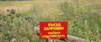
In some cases, the redistribution of land is considered illegal. This is an addition of land located in:
- someone else's private property;
- recreational area;
- forest fund;
- natural reserves;
- national parks.
Seizure is punishable by a fine under Art. 7.1 of the Administrative Code, as well as the Criminal Code, if it is related to criminal offenses, for example, fraud.
Adding a land plot to the main one in 2020
In September 2020, a new new law 150-FZ came into force, amending the laws on real estate registration and cadastral activities 221-FZ and 218-FZ. In accordance with it, cadastral work can be carried out in the absence of a land surveying project, if the norms of the Town Planning Code do not require its mandatory presence for a certain territory.
Land owners can legally expand the boundaries of the land they use. If during cadastral work it turns out that the area of such a plot is larger than the area registered in the Unified State Register of Real Estate, the excess of up to 10% of the registered one can be legally apportioned to your plot.
Let's legalize the cutting of land
We will do everything necessary to legalize the addition of a plot to your land.
- Let's calculate the permissible area of the cut area.
- If the main and cut-off areas differ in category and type of permitted use, we will determine whether the category and type can be changed.
- We will draw out the boundaries of the site in nature with the installation of boundary signs (if necessary).
- We will prepare an agreement on the redistribution of the land plot.
- If necessary, we will go to court to legalize the cutting, recognize ownership of the land, and establish boundaries.
- We will legitimize and recognize ownership rights to a building, structure, or unfinished construction site located on a land plot.
- We will prepare a draft application to the administration of the Moscow Region.
- We will represent your interests in the competent government authorities.
- We will help you prepare documents for state registration of property rights or to go to court.
- We appeal against the actions or inactions of bodies and officials that impede the speedy registration of property rights.
- We will advise on complex land issues.
Call for a free consultation +7 (812) 903-05-90
How to add vacant land to your plot in 2020
They resolved the issue of redistribution of land property, including the legal cutting of land. Therefore, any owner of land received or acquired for the purpose of gardening, truck farming, agricultural work or construction can apply to legalize the territory belonging to the municipality
Land expert
102244 On June 17, the President of the Russian Federation signed a new law, which, with its provisions, amended the norms of the Law on Cadastral Activities (RF Federal Law No. 221 of July 24, 2007) and the Law on State Registration of Real Estate (RF Federal Law No. 218 of July 13, 2015) - Federal Law of the Russian Federation No. 150 (from 06/17/2019). The text of the document was published on the Central Internet Portal of Legal Information on the same day. The bill was proposed by representatives of the Ministry of Economic Development.
- borders on land owned by the state (municipality);
- is not a public area;
- does not include the area on which communications, roads, ditches, etc. are located;
- the size of the resulting property cannot be greater than the maximum size of the land plot.
In 2014, significant changes occurred in the land legislation of our state. They allow owners of plots of land acquired for various purposes to increase them by annexing additional territory. However, this procedure does not provide for the payment of various fines and additional funds. How many acres you can add to your land plot, read in this article.
How many acres can be added to a plot of land: registration procedure
You can increase your original plot by no more than ten percent of the area, information about which regarding this land plot is contained in the state real estate cadastre.
Alexander Aivazovsky, living in the city of Zlatoust, Chelyabinsk region, decided to annex adjacent land to his land plot . The adjacent territory was part of municipal plots and was leased from Mr. Radchenko (who used the plot for growing crops).
What to do if the land plot is actually larger than according to the documents
When re-registering “additional acres” in your name, you should take into account the legal nature of these lands. Is it possible to obtain private ownership of this plot of land? This is the question every land user should ask when registering their rights to the “extra acres.” The Land Code contains a rule limiting the turnover of a certain category of land.
There are often cases when lands from the forest fund are adjacent to dacha plots. Taking advantage of the situation, citizens are taking over forest lands. Despite this, the Forest Code prohibits the registration of ownership of such lands. In this case, the length of time the land is in the use of the summer resident does not matter. It should be borne in mind that Article 71 of the Forest Code of the Russian Federation allows for the provision of land from the forest fund for free use for a certain period and for lease .
26 Jun 2020 glavurist 301
Share this post
- Related Posts
- In Which Cases Can You Terminate a House Purchase and Sale Agreement?
- How to pay the state fee for a passport through the Sberbank terminal instructions
- Traffic regulations where stopping and parking is prohibited
- Power of Attorney for the Sale of an Apartment Without the Right to Receive Money Sample
How many acres can be added to a plot of land: registration procedure
In practice, redistribution is called redistribution. That is, by adding to it we mean the ability of an individual who owns a plot to increase its size by adding additional land to it, which is located nearby (bordering it).
But this rule applies if the annexed territory in its area does not exceed 10% of the land to which it is annexed. If the amount exceeds 10%, the citizen will have to pay the full cadastral value of the land.
Interesting read: Choosing an individual tax system when registering