Author of the article
Elena Nikolaevna Karpova
Reading time: 6 minutes
AA
To do land surveying, you need to contact a specialist. He will carry out all boundary work and prepare the necessary documents. But this does not mean that the customer should not delve into the essence of the process. Knowledge of the land surveying procedure, even in general terms, will definitely come in handy. An informed customer will be able to choose the best specialist, refuse unnecessary work and check whether the contractor has prepared all the necessary documents. To find out the procedure for land surveying, you can read our article. It discusses all the basic rules and stages of land surveying, as well as its difficulties.
How is land surveying done?
First, let's understand the basic concepts:
- Land surveying is a whole range of services for establishing the boundaries of land plots both on the ground and in legal papers.
- Such services can be provided by land surveying companies, whose services are provided by cadastral engineers or specialists who provide services as individual entrepreneurs. These are specialists with specialized higher education and significant experience in this field. That's not all: a candidate for cadastral engineers must pass an exam and join a professional association of such specialists - SRO.
- Cadastral engineers in their activities rely on a special law and guidelines. There is also a whole series of explanations and letters from Rosreestr on the topic of land surveying, which does not make sense to list here.
Having a problem? Call a lawyer:
Moscow and Moscow region (toll-free call) St. Petersburg and Leningrad region
Rules and procedure for land surveying
All these norms are enshrined in the legal acts listed above.
In order for a cadastral engineer to begin organizing land surveying, you need:
- Conclude an agreement with him, if he is an entrepreneur, or with the company where he works.
- Create a task for an engineer. It indicates the entire list of work that needs to be performed.
In the process of his work, the specialist must comply with the following basic rules:
- Act strictly in accordance with laws and other legal acts;
- Work within the limits defined by the task (do not expand), and discuss all additional actions with the customer (in case he refuses);
- Observe safety precautions during work;
- Coordinate established boundaries with adjacent neighbors;
- Do not accept false documents from the customer for work;
- Other rules arising from the law.
The procedure for land surveying is enshrined in methodological guidelines and special instructions for surveying work.
The cadastral engineer must carry out all actions sequentially, starting with preparation, visiting the site and coordinating boundaries with neighbors and ending with the preparation of a boundary plan with land management.
Methods for surveying land management objects
In fact, this is a purely professional area.
How exactly should a specialist determine the boundaries of a site and establish its exact coordinates? He can make measurements of these boundaries using :
- satellite receivers;
- light range finders (these are tools for calculating distances between two objects, from the location of the device itself to the place where the beam emanating from it is reflected);
- photogrammetric instruments;
- theodolites (this is a device for measuring angles);
- and other technical means.
In order to then mark these boundaries on the map with coordinate points, and in relation to already established boundary landmarks, you can use different methods provided for by the land management rules:
- assistance from satellite devices;
- cartometry (calculate using existing maps);
- triangulation (a network of adjacent triangles is created on the map, and coordinates are specified using them);
- photogrammetry (when a 3D model is created from photographs of one object from different angles);
- other scientifically based techniques.
In principle, surveyors should use several methods at once in one job. This way the most accurate result will be obtained, and the permissible error during surveying will be reduced to a minimum. This means that it will be almost impossible to challenge it.
What is the procedure for land surveying with neighbors?
Before drawing up an assignment for survey work, the surveyor must find out what the reason for the survey is, and whether the customer has contacts of adjacent neighbors. The participation of neighbors in the process of establishing boundaries is mandatory. Otherwise, the meaning of the whole procedure is lost. After all, neighbors can declare their disagreement with the result after the survey and cancel them, since they did not have the opportunity to state their claims.
But the customer has the right to carry out this part of the work himself: to notify the neighbors and invite them to inspect the site to draw up an act on the approval of its boundaries. This way, land surveying will cost a little less; this should be discussed immediately when concluding an agreement with a specialist.
Stages of land surveying
All actions of a cadastral engineer can be divided into the following main stages::
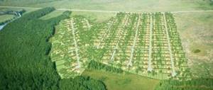
- Preparing for land surveying . At this stage, the surveyor collects all the papers for the site, both those that the customer has and those that are in the registry office. Documents are studied in detail in advance and compared with data from cadastral maps. A specialist can even go to this area and inspect it and the surrounding areas in advance, take measurements, look for the nearest boundary signs and other landmarks. In addition, at this moment, contacts of all neighbors whose interests may be affected during the land surveying process are sought.
- Then a technical plan is drawn up . It can be called a draft of the future boundary plan. This is not the final project; changes and clarifications will be made to it in the next stages.
- An important stage is sending out notices to all adjacent neighbors . Notification may be made by mail or delivered in person. In this way, the specialist invites subcontractors on a specific day and time to inspect and approve the boundaries. Naturally, people should receive such notification in advance, at least a week in advance. However, if adjacent contractors deliberately ignore notices of upcoming work, then land surveying without the consent of neighbors becomes possible.
- On that very appointed day, the customer, neighbors and the surveyor himself gather at the site . The latter once again inspects the area, boundary signs, listens to adjacent neighbors if they have objections, and draws up an act of approval of boundaries. If everyone is happy and there are no contradictions, then all neighbors confirm their agreement with a signature in this act. And the established boundaries, if necessary, are marked with boundary signs (poles). If there is a dispute and it cannot be resolved on the spot, then the disputants will have to go to court and resolve the conflict there.
- The surveyor then begins the calculations . The complex of boundary works includes determining the coordinates of already agreed boundaries and calculating the area of the site taking into account these boundaries. Methods for calculating coordinates are described above.
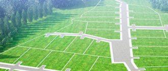
- Finally, the specialist begins to draw up a boundary plan for the site itself or simply a plan for its boundaries (depending on the task). This is the final document, it also contains a drawing of the site with scale, south-north direction, description of adjacent areas, area and other information.
- In conclusion, the surveyor must create a file in which all the documents that were used in the process of work and were prepared by the contractor himself are filed. The customer receives one copy, the second is sent to Rosreestr.
It is important to know that the plan cannot contain corrections, additions or deletions. This is practically a “clean copy”; everything in it should be perfect, without blemishes.
Documentation
The main papers that the customer of boundary work should receive are::
- Boundary plan (map) - an image of a site with boundaries and adjacencies, containing a descriptive part with basic information about the site and boundaries;
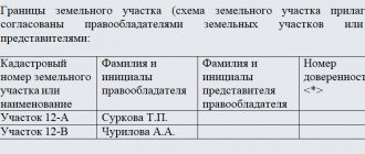
- Boundary approval act , which contains the signatures of all neighbors or indicates their absence or refusal to participate.
Surveyors must use several methods at once in one job.
With these papers, the land owner has the opportunity to further register the plot or enter into various agreements (sales or donations) in relation to it.
Timing and cost
If you are planning to survey your site, be prepared in advance for the fact that this process may not take place quickly.
Objectively, all this does not happen instantly; the contractor needs time to collect documents, calculate and formalize all the results. Not to mention the need to gather all the neighbors in one place and at one time. If someone does not show up, they will have to be notified again and wait thirty days for a response or appearance. In general, it will take approximately one to one and a half months to complete the entire procedure. But this period may increase if unforeseen situations arise (absence of neighbors, their disagreement, etc.).
As for the cost, it depends on the characteristics of the site itself, the presence/absence of documents for it and the region of the country in which it is located. The price is also affected by the amount of work required. It was already noted above that the price can be reduced by notifying neighbors. Read more about how much land surveying costs right here.
Typically, the cost of boundary work varies from 2 to 50 thousand rubles.
Cadastral works
The procedure for collecting applied information for drawing up title documentation characterizing a specific property is called cadastral work . The main goal is to prepare up-to-date data for paperwork required when registering a land plot or building in RosReestr.
This procedure is regulated by Federal Law No. 122 .
Attention. If you have any questions, you can consult with a lawyer for free by phone throughout Russia. Calls are accepted 24 hours a day. Call and solve your problem. It's fast and convenient.
Carrying out cadastral work is necessary to obtain an extract - the main title documents characterizing the property. This procedure is carried out by a qualified individual - a cadastral engineer who has a standard license. This person carries out professional activities in a government agency or private company on the basis of an agreement to conduct engineering surveys or a power of attorney from an executive authority. Also, his professional activity can be formalized by a contract concluded with a private company.
In Russia, a qualification certificate is issued to an engineer based on the following conditions:
- Secondary vocational or higher education.
- Availability of Russian citizenship.
- There is no outstanding criminal record.
The certificate is issued by the regional branch of the executive power for an unlimited period . The document is valid throughout Russia.
According to the legislation of the Russian Federation, if within a year of 10 projects is refused , his license will be cancelled.
The contract for cadastral work must contain:
- Names of the customer and contractor.
- The subject of the agreement indicating the property or land plot, as well as a list of documents presented upon completion of the transaction.
- Duties of the parties and their responsibilities.
- The deadline for completing a task with delimitation of periods for the execution of highly specialized work. For example, the date of the topographic survey and the time allotted for preparing the building plan drawing.
- Cost of services and payment procedure.
- Methodological recommendations for acceptance and delivery of completed work.
- Addresses and payment details of the parties.
Features of cadastral work
The procedure for carrying out cadastral work can be divided into two main stages :
- Topographical survey of the property and its photography. This operation is necessary for drawing up a boundary and/or technical plan. The initial analysis takes several hours.
- Processing of received data for the preparation of title documentation. This stage takes from one to several weeks depending on the complexity of the property in question.
Initial actions are carried out when the engineer directly visits the property to analyze and collect up-to-date information. Organization of further preparation of documentation is carried out using the latest application programs on a computer. At the same time, the state real estate cadastre is maintained in electronic and paper form. In case of discrepancy between data on different types of media, physical documents take precedence .
The cost of cadastral services is determined on the basis of a contract between the customer and the contractor. The document must contain a fixed payment price in national currency. Obligations come into force from the moment the customer signs the contract.
Deadlines for cadastral works
Article 17 of Federal Law 122 defines the following terms for conducting cadastral work:
- Registration and deregistration of a property or part thereof is carried out within 10 working days .
- Changes to documentation, as well as cadastral registration, based on information interaction with other authorities, are made within 30 calendar days, excluding weekends and holidays.
The date of completion of office work is recognized as the day on which the procedure for registering changes or termination of data on the specified real estate was carried out.
Documents received upon completion of cadastral work
Upon completion of cadastral work, the following documentation is issued:
- Land survey plan. It is drawn up according to the structure of cadastral papers and contains basic information about real estate or land. The boundary plan is divided into graphic and text sections. The first part clearly displays the site diagram, the second contains the basic data for registration.
- Technically the plan. Contains information about real estate necessary for registration of construction in RosReestr. The eight-page document includes detailed information about the property in question.
- Inspection report. Drawed up in the event of irretrievable loss or destruction of real estate. Prepared electronically with certification by an electronic digital signature. If necessary, it is drawn up in writing with certification by the seal and signature of the responsible person.
Conclusion
The main goal of carrying out cadastral work is to obtain title documentation, on the basis of which state registration will be carried out in RosReestr.
- These works are carried out by a certified engineer of an executive authority, BTI or a private company.
- The documentation preparation procedure is divided into two parts : geodetic inspection and processing of the received data.
- of 10 days is established for the listing and removal of a property 30 days for information interaction .
- The result of cadastral work is the provision of one or more title documents to the actual owner: technical plan, boundary sheet, survey report.
List of laws
- Federal Law No. 122