With the onset of 2020, the right to dispose of a land plot without restrictions, without prior land surveying, will become limited, and this condition applies to everyone, including its owner. This term refers to the exact designation of the boundaries of the site, which were previously established in approximate form. Today, the law on land surveying assumes that in order to put the situation in order, it will be necessary to carry out a whole range of works related not only to geodesy, but also to their legal registration.
Description of the law
The regulation of all aspects related to land surveying is dealt with by such a document as the Land Code. These aspects are directly contained in its 11th article, and the most recent changes and additions were made by Federal Law 361-FZ. In particular, this law states that during the procedure for registering a disputed site in the federal register, land surveying is mandatory, without which this process is impossible. The conditions for the demarcation were determined by the Federal Law “On State Registration of Real Estate” N 218-FZ, adopted in 2013.
Land surveying is one of the mandatory procedures that can be used to determine whether the owner owns his land; the legislation does not provide for other options for resolving this issue.
With the onset of 2020, without carrying out the land surveying procedure, it will no longer be possible to carry out actions with a land plot to change its owner.
What lands should be surveyed?
It turns out that the procedure is recommended for owners of any type of land that is officially owned. Why does such a serious decision have official status? Initially, it is important to note that in the Russian Federation there are indeed many land plots occupied by capital structures that have not undergone official registration. That is, no one paid land tax from them. Just count that in the Moscow region over the past year there were about 600 thousand of them, and in the state the figure will be definitely higher.
This is interesting: Legal advice on debts, debt collection deadlines
Most of the land belongs to gardening partnerships, vegetable gardens, dacha cooperatives, and was issued to company representatives back in Soviet and post-Soviet times. Only those owners who have drawn up documents in the past and have the corresponding act in their hands can not worry about the need to draw the boundaries of the territory. If you do not have this document stored in the archives, or you recently purchased the land, you need to request an extract from the state register for the territory, and based on its results, make a decision whether the procedure is required or not.
The concept of land surveying
Indicating the boundaries of a land plot using special signs and preparing a corresponding plan is the definition of the concept of “land surveying”. It is in many ways similar to cadastral activities, but between these terms, despite their similarity, there are differences. First of all, it is necessary to understand that land surveying is an integral part of cadastral activities, which is the preparation of certain documentation necessary for the implementation of the entire procedure.
Land surveying becomes mandatory for the following situations:
- when property is transferred from communal or municipal property to private hands;
- when performing operations on the division of land plots;
- when combining two or more plots;
- when carrying out the process of land redistribution.
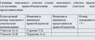
Sample boundary plan of a land plot
A boundary plan may look like this: This document can serve as a visual confirmation of the fact where the boundaries of garden or summer cottage plots are laid. It can also be submitted to the court for the consideration of disputed cases regarding property.
Typically, orders for land surveying come from those owners of plots who have disputes about the boundaries between them. At the same time, there is often a misconception that in order to resolve disputes it is enough to wait for a cadastral engineer who will perform all the required measurements and thereby solve the problem. In reality, everything is different, a cadastral engineer can only record where exactly the boundaries lie, and the owners themselves must either reach an amicable agreement among themselves or go to court to resolve the dispute.
How to draw up a land survey plan for a multi-circuit area?
Multi-circuit areas are those consisting of at least two closed parts. This type of plot is divided into two groups:
- areas consisting of two or more contours;
- areas that have inclusions within them.
The last option is very common among rural residents, when on opposite sides of the road there may be a residential building with outbuildings and a vegetable garden. In fact, we are talking about two different areas, but the document is drawn up and issued for one, but the boundary plan must contain an indication of such a division. In addition, it must indicate all the initial data of the specified territory. It should be noted that the assignment of a number applies to the entire plot, regardless of the number of its components; individual plots cannot receive their own number.
When will the boundary plan need to be replaced?
There is no information in any legislative act about how long after surveying it is necessary to update the survey plan.
For this reason, we can say that the boundary plan does not have a validity period, that is, it is unlimited.
However, if certain circumstances arise, you will still have to update the boundary plan.
Such circumstances include:
- changing the boundaries of the memory:
- clarification of boundary lines;
- change of geodetic points on the initiative of the State Committee for Land Control;
- division of a storage unit, allocation of its share or connection with other storage units;
- errors were discovered in the boundary plan;
- imposition of memory.
The listed situations require repeated surveying if desired by certain government agencies, interested parties or owners.
If the measurement systems in the geodetic network change, the survey will also need to be done again.
In addition, the boundary plan may no longer be relevant if legal requirements change. This is a prerequisite for constantly monitoring changes made to the legal acts.
Documents for land surveying
Only those organizations that have a license for land management and geodetic work can carry out this procedure. It can only be carried out on the basis of an officially concluded agreement.
To complete the application, the following documents are required:
- the applicant's identity card;
- confirmation of land ownership;
- a copy of the general plan of the area;
- site plan and its cadastral passport.
Everything looks quite simple and even easy, but only in theory. In practice, one often encounters serious difficulties and problems. First of all, the human factor can play a negative role, because relations with neighbors are not always good and the lack of clearly defined boundaries of the site can become a real stumbling block in this matter. There are cases when real wars break out over just a few centimeters of land. Many people act on the principle “whoever got it first is right,” so situations may arise when, during the land surveying process, it turns out that a piece of territory has already gone to a neighbor. As a result, you have to participate in long proceedings and in courts, and with far from clear chances of a positive result.
Who has the opportunity to use the dacha amnesty?
“Dacha amnesty” can be used by the following categories of persons:
- Any citizen of the Russian Federation who has an indisputable right to a plot of land or an individual house.
- The owner of the plot, who is part of a gardening partnership or cooperative. (Suppose you are the owner of only the membership book of a gardening partnership, and there are no other documents confirming ownership. In this situation, you can contact the local administration and begin registering your rights).
- A Russian citizen who has documentation of the right to the plot, however, says nothing about ownership. The “dacha amnesty” mechanism creates the opportunity to obtain a certificate of ownership using a simplified mechanism.
Law No. 171 of 2014, concerning the “dacha amnesty,” significantly simplifies the mechanism for registering real estate. The certificate of this will be in the hands of the owner much faster and easier. Changed individual regulations extended the validity of the law until March 1, 2021. All this proves that the relevance of this topic does not decrease and the complications arising in connection with this do not disappear.
However, many Russians did not take advantage of the simplified scheme, hoping for an extension of the legislation, which is what happened; until March 2021, applicants can register ownership of a land plot by submitting a minimum of documentation.
You just need to remember that only members of dacha, vegetable gardening and horticultural partnerships can use the amendments. In essence, the “dacha amnesty” procedure remains the same.
The term “dacha amnesty” refers to a simplified registration method, with the help of which you can register ownership of a real estate property anywhere in Russia.
To launch the mechanism for completing the necessary documentation using the “dacha amnesty,” you first need to make sure that you have a legal document confirming your right to own the real estate you intend to register.
Others have a problem: the issuance of a legal document was carried out a very long time ago. This does not matter if your documents are prepared in accordance with all legal requirements that existed in the state at that time.
In 1998, a legal registration system was launched, the relevance of which has remained to this day, in connection with which a document certified in accordance with all existing requirements by a local government authority, for example, a certificate issued by the Bureau of Technical Inventory, will act as a valid title document.
Thus, if a similar document is available, one problem can be considered solved.
When you are confident that any land plot belongs to you, but this is not documented, you need to send an application to the administration to obtain an extract from the materials of the business book.
When it is impossible to obtain an extract, there is only one way left - it remains to buy the plot from the municipality or government agency.
Taking this into account, the “dacha amnesty” mechanism, the period of which has been extended, is only suitable for the owner who has an old title document.
For example, Law No. 122 has an article that confirms the legal validity of a previously received land document.
Do I need to hurry up in obtaining a new type of title deed?
Many property owners still have doubts about the need to re-register. No one, of course, obliges land owners to make a new type of certificate.
However, if alienation is necessary, you will not be able to find information about yourself in the Unified State Register of Real Estate Rights (USRE), which can lead to negative consequences.
At the same time, in the case under consideration, sometimes it is possible to achieve the desired solution to the problem. When registering the right to a plot, it is necessary to immediately register the transfer of rights to the next owner.
Taking into account the fact that the state fee must be paid for only one registration procedure, there is some savings.
Of course, such a “double” deal is rarely carried out. It can take place in a transaction in which relatives or trusted friends take part, when there is absolute trust between the parties.
If the transaction is intended to be carried out by unfamiliar individuals or legal entities, then before the transaction is completed, you may quite legally be required to have a document of ownership. This is often how they protect themselves from scammers.
For some plots, ownership rights are registered automatically.
For such a site, the legal title is:
- A document that does not indicate specific ownership rights to the site.
- An act or certificate that grants a perpetual right to use or possession, inheritable for life.
- An act for the indefinite use of the site from the relevant services.
- Extract from the household book.
If you have any of these documents, the procedure for registering property rights becomes much simpler.
When there is such a document, and individual housing construction is being carried out on the site or it is used for growing a garden or vegetable garden, then in order to obtain registration, only this document and an application are sufficient, which are submitted to the territorial body of Rosreestr.
This mechanism is set out in the law regulating the introduction of the Land Code of the Russian Federation.
Is the procedure mandatory?
If the owner of a land plot does not want to carry out land surveying, then he has the right to do so, but it should be taken into account that in this case he will not be able to perform any actions with it to change the owner (donation, sale, inheritance, pledge, and so on). The Law “On State Registration of Rights to Real Estate” states that in order to obtain title documents, information about the boundaries of the plot is mandatory, therefore, it will not be possible to do without land surveying.
Dacha amnesty extended until 2020 - register land or house
The “dacha amnesty,” which is quite relevant in all regions of Russia, has already been extended twice after the immediate adoption of the law. And, despite various obstacles and disagreements, this law still works today, enjoying considerable popularity. In fact, the federal law, adopted back in 2006, has a rather long official name (now Federal Law No. 20-FZ of February 28, 2015
“On amendments to certain legislative acts of the Russian Federation”
), and only in colloquial use is it called nothing more than a dacha amnesty.
Citizens of the Russian Federation with an indisputable right to a land plot or residential building.
The owner of a plot owned by a garden partnership or cooperative.
Changes in the law on land surveying
In accordance with the new changes made to the text of the law “On State Registration of Real Estate” dated July 13, 2015 N 218-FZ, “from 2020 land surveying becomes a procedure that is now mandatory. If you refuse to carry it out, then no real estate transactions involving a change of owner will be possible. This is directly indicated by paragraph 1 of Article 19 of this document.
The law has also undergone other changes, in particular, Article 22 now states that the basis for the boundary plan is the cadastral plan. Such a document consists of two parts: text and graphic, the first contains information about the site and its buildings, the second represents the territory in question, marked by boundaries.
Is there a limitation period for registering the boundaries of a land plot?
In accordance with Articles 208 of the Civil Code and 304 of the Civil Code of the Russian Federation, there is no statute of limitations for resolving such boundary issues.
The cadastral law on land surveying states that this procedure is voluntary. But there are cases when it is necessary to do it. Consider these cases:
- The legally established boundaries of the land plot have been adjusted.
- Sale of part of a land plot, annexation of additional land to it, or inheritance of a land plot by several owners. If the land plot was divided into shares, each owner will have his own certificate and certain boundaries.
- The owner of the land plot wants to increase its territory, having agreed with the local government. If the administration has provided for the norm, then it will not exceed several hundred. In the absence of a norm, it is possible to add up to 10% of its area to the land plot. With such changes, land surveying will be mandatory.
- The presence of controversial situations with the owners of neighboring lands. Determining the boundaries in this case will prevent the latter from seizing the land.
- If it is planned to erect buildings on the land plot.
- Complex site configuration. Only boundary work in the presented case will help determine the exact boundaries.
- The plot is going to be sold, donated, exchanged, inherited, pledged or leased (until 2020, these manipulations were possible without carrying out boundary work).
Amendments to the law, which came into effect in 2020, allow the registration of rights only to shared property and lands that were annexed from local authorities by redistribution.
Changes for 2020
Changes in the Land Code came after amendments dated June 1, 2015. In order to reduce unregistered territories and to organize information about areas, authorities received the right to clarify their boundaries independently. Thanks to this decision, there was an increase in tax revenues, since people pay for the land that actually belongs to them. What is important here is the fact that such land surveying is carried out at the expense of budgetary funds; the owners do not have to pay anything during its implementation.
By what year should it be done?
So, let’s consider until what year land surveying can be done, and when it will become mandatory for land plots. According to Federal Law No. 447, all lands for which transactions will be registered must undergo a land surveying procedure. Without this, any operation with the plot (sale, donation, bequest, lease, registration of ownership, association or division) will be impossible to perform.
Until 2020, all operations with land could be carried out using a cadastral passport without mandatory land surveying. Typically, this process was carried out only when controversial cases arose or when appealing to the judicial authorities.
How to determine whether land surveying has been carried out? This can be found out from the cadastral passport. In it, in the “Special Notes” section, in a situation where the size of the allotment was not determined, there will be an entry “Border not established.”
From January 2020, the owner loses the following rights in relation to the land territory if he refuses the boundary procedure:
The owner will not be able to legally construct any building on the site and register it as a real estate property.- The owner will not be able to sell, gift, bequeath or lease his land.
- The owner will not be able to provide a plot of land as collateral for a loan.
- It will be impossible to split the plot into several or combine the plots into a single territory.
It is worth considering that land surveying is not a free procedure. Today there is no rush to establish boundaries yet. When the law comes into force, the queues for specialists determining boundaries will increase significantly. Prices will also increase due to demand for this type of service. So it’s up to you to decide when to do land surveying.
The obligation to survey land plots by their owners is enshrined in law and a specific period is established for this. After 2020, all lands whose boundaries have not been established will become unavailable for transactions. This means that it will become impossible to sell or donate a plot that has not undergone the land surveying procedure.
The most unpleasant moment will be the fact that the structure that will be erected on it will be illegal. It will not be possible to formalize it, since there is no boundary plan for the land underneath it.
After January 1, 2020, it will be impossible to make an alienation if the land survey procedure has not been carried out. This means that it will be impossible to re-register ownership of the property to another person under any circumstances.
Neither the heir nor the buyer will be able to obtain title documents. It will also not be possible to donate a plot of land that has not been surveyed.
The advance adoption of Federal Law No. 447-FZ is due to the need to improve the quality of services provided by the state cadastre and to establish the indisputability of registration rights to real estate.
Thus, the sequence of actions is as follows: first, A. registers ownership of the plot, then a purchase and sale agreement is concluded and the transfer of ownership to the new owner of the plot is registered. The extension of the Dacha Amnesty Law is quite a good help for those who have not yet managed to register ownership of real estate. In addition, unlike, for example, privatization, an unlimited number of objects can be registered under the dacha amnesty.
Deadlines for land surveying according to law
According to legal requirements, after informing the owners of neighboring plots of their intention to leave the partnership and carry out land surveying, at least 30 days must pass. This time is allotted to them to make a verdict on agreement or disagreement with the proposed work. A period of 1 to 5 days is allotted for carrying out geodetic work; measurements may require a lot of time due to weather conditions or landscape features of the site.
Having received the result, the customer must provide information to the state register and register ownership rights. This takes from three to six months, depending on the complexity of each specific case.
The period for which land surveying must be carried out
How to carry out land surveying? The entire legal basis for mandatory activities, including the preparation and conduct of land surveying, can be read in Federal Law No. 221 dated July 24, 2007. A number of amendments have been introduced to it, which came into force on January 1, 2020.
Let's mark all the stages sequentially:
- Preparation of all necessary documents. These include: civil passport of the owner of the site; SNILS; documents confirming land ownership, as well as, if necessary; power of attorney. If a plot of land does not have a connection to centralized communications, then certificates about this will be required from the relevant services.
- Finding a cadastral engineer and concluding an agreement with him to carry out land surveying work. It’s worth going into more detail here.
We suggest you familiarize yourself with: Check the imposition of restrictions on a car by bailiffs.
Only a specialist can carry out the process of establishing the boundaries of the site, its area and exact location. This is what a cadastral engineer is. This can be any person (individual, legal entity or individual entrepreneur), but must have an official document. A certificate issued and registered in Rosreestr is confirmation that he has sufficient qualifications to provide such a service.
To obtain such a certificate, candidates are subject to a number of requirements: they must have a professional education, as well as pass exams to confirm their qualifications. In addition, the engineer will be allowed to work independently only after a two-year internship as an assistant cadastral engineer with experience.
It should be noted that the quality of work of such specialists has improved as a result of successful reforms in this area.
- After concluding the contract, the cadastral engineer goes to the site where he records the coordinates of the points on the site. Then, based on the instrument readings, marks are set and the area of the allotment is calculated. These marks with the drawn area will then form the basis of the boundary plan.
- If the boundaries of the site are adjacent to neighboring territories, then they must be coordinated with the neighbors. To avoid being caught off guard, 30 days advance written notice is required. If none of the neighbors show up on the appointed date, then the survey is carried out without their presence. Notifying neighbors about the date and time of survey is a very important point. If they agree with the boundaries, an Act is drawn up indicating a number of details, so be sure to inform them that their passports will be needed. Disputes with neighbors often occur during land surveying. This is a common practice that results in refusal to sign the Act. Be sure to document any claims or refusals and require a signature. This paper can be decisive if the case goes to court. However, not everyone likes spoiling their nerves and forever making enemies in the person of their neighbors and it is better to seek a compromise.
- Formation of land surveying. Once boundaries are marked and agreed upon, all data collected on site is compiled into one file. The period for preparing the boundary plan must be fixed in the contract.
- Receive a finished plan. On the agreed date, the owner of the plot is given a boundary plan and a description of it. These documents can be submitted to the Rosreestr authority.
- Next, all that remains is to register the plot of land, for which you will need to prepare several more documents that will need to be presented to the registration authority. In addition to the boundary plan, you need to take with you a passport and documents confirming the right to this site. An application in the prescribed form can be filled out directly at the Rosreestr authority. All that remains is to pay the state fee and wait for changes to be made to the database.
A quarrel over the division of land turned two neighbors into enemies
There is no legal deadline for completing land surveying work. It is formed from several criteria:
- terrain features,
- terrain complexity,
- number of areas for land surveying,
- allotment area.
https://www.youtube.com/watch?v=Y7ohL6ae4DA
If the boundaries of a plot for individual use, as well as a dacha plot, are marked, and there are no disputes regarding the marking with neighbors, then the process takes approximately 15-20 days. The exact date of completion of the work by the cadastral engineer can be specified in the contract.
More details:
- Personal application to Rosreestr, or submitting a request through their official website.
- Request for documents at the MFC or on the State Services Portal.
- Determining the presence/absence of a land plot's cadastral number and established boundaries using a public cadastral map.
The order in which land surveying should be carried out is stated in Article 11.10 of the Land Code of the Russian Federation. Boundary setting is carried out by geodetic companies licensed for this type of work.
The cost of such a procedure will differ depending on where the land is located, for what purpose it will be used and why the boundary work was required. The average cost of the procedure is 15,000-20,000 rubles.
So, to carry out land surveying, you need to take the following steps:
- Request to a geodetic company. To draw up an agreement confirming that engineering and geodetic work has been carried out, you need to prepare a passport of the land owner (or a passport and power of attorney for a representative) and a document confirming the right of ownership of the land plot. You may also need a certificate from Gorsvet confirming the absence of an electrical cable in the land plot and a certificate from the administration indicating that there are no public communication networks in the land plot. After submitting the documents, the geodetic company draws up an agreement with the land owner, which includes the price of the services provided and the timing of their implementation.
- Warning to owners of neighboring land plots. It is required to notify all neighbors of your storage unit, if any. Their presence is desirable when carrying out boundary work. The company itself, which provides land surveying services, or its owner can warn neighbors. With the latter option, it would be better to personally convey to neighbors information about the upcoming work and the date of its completion. In this case, a signature is taken from each neighbor indicating that he was notified and invited to establish boundaries. The general notice is then sent to the cadastral engineer who will carry out the work. If the neighbors whose signatures are on the general notice did not come on the date of the work, this is not a reason for canceling or postponing it.
- Directly the land surveying itself. Measuring the area, fixing the boundaries of the land plot, coordinating them with the neighbors present, drawing up a report on the work done. The act must be signed by the neighbors, the owner of the land plot, the cadastral manager and a representative of the municipality (he will be warned by the geodetic company).
- Preparation of land surveying. After completing all the work and processing the documents, the owner of the land plot is invited to receive ready-made documents on land surveying. The owner keeps the first copy of the land survey file, the second is sent to the Cadastral Chamber so that the land plot can be assigned a cadastral number.
- The land plot is registered with the cadastral register so that the owner receives a cadastral passport for the land plot. You will have to wait about 2 months for this document after the boundary plan, document on ownership and a receipt for payment of the state duty (200 rubles) are submitted to Rosreestr.
- Registration of property rights. This requires a personal application to the MFC or Rosreestr, or documents can be submitted via mail or the Internet. There is no need to re-submit documents. All you need is an application and a receipt for payment of the state duty. Rights will be registered within two weeks.
Compliance with survey deadlines is extremely important. Some of them are required to be carried out by the cadastral engineer, others - by the owner himself.
So how long does land surveying take? Let's consider the basic requirements for deadlines when determining the boundaries of the memory:
- Owners of neighboring plots and other interested parties must be notified of the planned land survey no later than a month before the work. However, the owner may not always know the exact date of arrival of the surveying company’s employees. Therefore, it is better to notify neighbors a month before an agreement was concluded with this organization.
- The engineer must carry out work to determine the boundaries of the land plot 2 weeks after the contract has been signed and the agreed advance has been paid by the owner.
- The measurement work itself is completed in 1-5 days. This period may be affected by weather conditions and terrain.
- The completed documents must be issued to the customer no later than in 2 weeks.
- It will take 1-3 months for information about the land plot to be entered into the state register, as well as for the property rights to be registered, and in a complex case – no more than 6 months.
The survey period can be extended if the landfill is located at a sufficient distance from the company that will measure the boundaries. But even in this case, the extension should not exceed one month.
If the land survey was carried out in such a way that it violated the rights of certain persons, the latter may exercise their rights indefinitely, regardless of the results of determining the boundaries.
But if land surveying is carried out incorrectly in violation of the boundaries of the customer or the owners of neighboring plots, this is considered a violation of property rights that can be protected, which is done through the court.
We invite you to familiarize yourself with: Car service patent taxation system
When filing a claim in court, its statute of limitations may be 3 years. And during this time, land surveying can theoretically be challenged.
However, due to the fact that each piece of land is subject to tax, the violation of the right is considered permanent. That is, the violation of property rights will not be a one-time violation in this case, due to the fact that it causes other consequences (violation of the Tax Code, and so on).
Due to the fact that this violation is permanent, it will not be subject to the statute of limitations.
But if you additionally register a plot of land, then add another 200 rubles);
- applicant's passport;
- power of attorney for a representative;
- cadastral passport for the construction site;
- title document for a land plot. It is provided only if the land plot is not registered in the manner prescribed by law. If information about the site is in the Unified State Register, then such a document is not attached to the application.
Peculiarities
Notification of other members of the partnership, for example, gardening, about the desire to leave its membership can be done either at a general meeting or by mail; the law does not provide restrictions in this matter. Within a month you should wait for possible claims; if there are none, then you can begin the land surveying procedure.
Thanks to its implementation, the owner receives more opportunities to protect his interests. First of all, clearly defined boundaries of the site provide a guarantee against encroachment by neighbors on its territory. If during the land surveying process it turns out that the very first plot was identified incorrectly, then it will be the most difficult for the owner of the last one, since it will not be easy to prove his case in lengthy and complex legal proceedings due to the interests of numerous owners of neighboring plots being affected.
Choosing an organization
You can turn to the services of various companies and organizations that are engaged in land surveying. There are many of them, which often gives rise to the problem of making the right choice. What points should you focus on in this case? First of all, the company must have a license allowing it to engage in such activities. Further, it is better to turn to the services of those who have average prices in the market; chasing a low cost means increasing the risk of turning to not the highest quality specialists. It is also advisable to study reviews about the activities of a particular company, fortunately, the Internet provides such an opportunity. Finally, it’s good if the organization provides full documentary support, this will relieve the customer from the need to knock on the thresholds of various authorities himself.
How to resolve a dispute with neighbors?
You can notify your neighbors that engineers are expected to arrive for land surveying in a variety of ways, including by telephone or social networks, but it is better to do this by registered mail. Such an official procedure will be most reliable. When drawing up an act on the approval of land surveying, the consent of neighbors with the drawn boundaries, as well as their identity cards, will be required. If the matter concerns an allotment in gardening or in a dacha partnership, then you will also need to obtain the consent of the chairman of its board.
It rarely happens without controversy; the reasons may include a variety of aspects, ranging from the planting of certain crops on “foreign” land to memories that 10-15 years ago the border passed in a different place.
It is still advisable to reach a compromise with the neighbors, but if it is impossible, then you will have to go to court. This option has many difficulties: in addition to the tedious and rather long proceedings, you will also have to spend a lot of time on the preparatory stage of this process. You will need to collect all the documentation, including an extract from the Unified State Register for both plots, yours and your neighbor’s, documents for the passage of communication lines through the territory, find out the boundaries of environmental zones and find out the history of your land in terms of previous owners, area, and so on.
Often, a land survey is required for legal proceedings; it is not cheap, in the region of 35-40 thousand rubles, plus various costs will also add up to significant expenses. So if you can give in to your neighbor in some small detail, then it is better to do so, so as not to face much more serious problems and expenses later.
The cost of surveying privately
The owner has the right to carry out land surveying privately, without using the services of those specialists provided by the municipal authorities. It is worth considering that in this case the procedure will not be free.
The price range in this case can be quite large; it ranges from 2 to 15 thousand rubles. Pricing can be influenced by many factors, such as the type of work performed. The most expensive operation will be the allocation of a plot; here the price varies depending on its characteristics. A technical plan will cost approximately 4 thousand, a topographic survey of the territory will cost one thousand, but this is an average cost, it may vary in different regions.
We must not forget that each company providing such services has its own rates and pricing policy. The price may also be affected by the regional characteristics of the site, its location on the ground and the configuration of the territory.
New law on 10 percent of the land area - we register surplus land
- the plot should not be less than 10 percent of the area indicated in the Unified State Register of Real Estate;
- It is allowed to change the area of the plot in a larger direction, but without exceeding the dimensions:
a) to the maximum minimum area established by local authorities; b) if the minimum size of the plot is not established, then no more than 10 percent of the area of the land plot specified in the Unified State Register of Real Estate.
We described in more detail how to increase a land plot at the expense of the adjacent territory in 2019 and register excess land through additions in the articles: “Addition of a land plot in 2020” and “Redistribution of land plots.”
The new law 150-FZ dated June 17, 2019 speaks not only of the possibility of increasing the area of the site, but also of the fact that new boundaries established during complex cadastral work can be reduced. This happens when Rosreestr contains information about your site that does not coincide with the actual data (the boundaries are being overlapped with another site, etc.).
When the discrepancies are minor (up to 10% of the total area of the plot), then, according to the law, information is entered into the Unified State Register of Real Estate, according to the newly prepared documentation on complex cadastral work, and no one asks the owner’s opinion. However, when the discrepancies are more than 10 percent, then the new boundaries must be agreed upon with the owner and the approval act, along with a package of documents, must be submitted to Rosreestr.
“Land surveying in 2020 is free.” Thus, in 2020, Vladimir Putin officially allowed Russians to register surplus land (up to 10% of the total area of the land plot) for free in the territory where complex cadastral work is being carried out. All that remains is to find out where and when these complex cadastral works will be carried out and who will be the lucky owner of the free registration.
How to survey a plot of land for free?
If the initiator of the land surveying procedure is the municipal authorities, then it is carried out free of charge. For example, it was previously performed incorrectly and this gave rise to many disputes; in this case, a special commission is created, which will deal with the implementation of this procedure.
The first step is to notify all interested parties about the survey. Cadastral engineers most often carry out markings differently than the owners want, which gives rise to a lot of disputes and conflict situations. You need to be prepared for this, since every second case, according to statistics, gives rise to disagreements and litigation.