Disputes over land plots are often the subject of litigation.
Citizens who own land as property rights defend their rights to use the property and to the established boundaries of the site.
To prove a particular right to land or its essential characteristics, a land survey may be carried out.
Most often, it is carried out in court when the submitted petition is satisfied by the party to the dispute. It must be carried out by an independent expert organization that is not interested in the outcome of the case under consideration.
The concept of land management expertise
What is land management expertise? This is a study of the boundaries of land plots in comparison with the indicators stated in the documentation. In addition, the examination makes it possible to identify the prospect of dividing the site into small components.
In addition to the site itself, as part of expert actions, all title and title documentation is studied in detail.
The objects of research in land management expertise are land plots, zones and individual territories, as well as land management documentation in the form of diagrams, maps and drawings.
Independent expertise solves a large list of problems:
- Determination and reflection of the boundaries of the site, the procedure for its use and indicators of the cadastral and market value of the land;
- Study and evaluation of survey materials;
- Preparation of options for dividing the plot according to shares.
The examination resolves issues of the legality of buildings on the territory and helps resolve conflicts with neighbors regarding the ownership of disputed lands.
What is it for?
Land plots can change hands, change their boundaries, divide and merge. All changes may give rise to overt disputes and implicit disagreements between land claimants.
Land surveying expertise required:
- for registration or re-registration of a site;
- when marking the territory;
- establishing the presence of immovable objects on the site;
- checking the accuracy of the information set out in title documents;
- division of home ownership between heirs;
- determining the procedure for using the site;
- neighbor disputes;
- drawing out the boundaries of the site.
Most often, the subject of a land dispute is the boundaries of land plots . When the boundaries of one land plot overlap another, inconsistencies arise in the technical documentation and disagreements regarding the ownership of disputed territories.
Issues of land management examination when imposing land plots are established by the court or the party voluntarily organizing the examination.
The following list of questions is usually approved:
- Determine the boundaries of land plot No. 1 and plot No. 2.
- Do the boundaries comply with the legal documents?
- Indicate what changes are needed in the Unified State Register if errors are identified in the boundaries of the plots.
- Prepare possible options for establishing the boundaries of site No. 1 and site No. 2.
Other questions can also be used, the main thing is that during the inspection the expert’s position on the subject of the dispute is clearly clear. Issues that are submitted to the expert for decision are recorded in the minutes of the court session.
The expert may refuse to answer other questions if they are not written down in the court decision on the appointment of a judicial land management examination.
What is a forensic land survey
In Russia, disputes over land plots happen very often. But in order to resolve them, a forensic land survey must be carried out. Of course, a person can carry out this action independently, but in most cases the examination is ordered by the court. It is on the basis of a court decision that a land management examination can be legally and legally carried out, the results of which will be considered by the judicial authority and, on the basis of them, a decision will be made to satisfy or reject the claims put forward by the plaintiff.
The concept of land management expertise from the legislation of the Russian Federation
Land management expertise is a set of techniques and methods by which you can answer the necessary questions. It solves problems such as:
- Determination of the boundaries of the land plot owned by the owner;
- Determination of the total area of the land plot belonging to one or another owner, as well as its compliance with that specified in the documentation;
- Determination of the value of a given land plot, as well as its comparison with the specified value in the documentation for it;
- Determining the possibility of conducting a particular activity on a given land plot, as well as the possibility of including the site in the list protected by law;
- Determination of the owner of the land plot, as well as his rights to this plot.
A land survey will help resolve many other issues that arise in court when determining the right to a given land plot.
Land management examination can be carried out only in relation to certain objects, which are usually lands. It can be carried out in relation to the following areas:
- Lands owned by territorial authorities;
- Lands owned by municipalities, as well as the administration of the locality;
- Lands that belong to citizens of the Russian Federation.
When is an examination necessary?
Land management examination can be carried out not only in relation to the land plots themselves, but also various documentation on it. This can happen when the document describes data that does not correspond to the actual parameters. Such documents may include:
- The results of the land management examination itself;
- Various land plot schemes, as well as state land management;
- Any land management maps if they contain inaccurate data;
- Documents that define the boundaries of the land plot;
- Documents that determine the content of minerals in the bowels of the earth of a given site.
The court may review and send for further study by the land management expert other documents that clearly indicate inconsistencies with actual norms and rules.
Land management examination can be carried out in different cases. Based on this, it was given the appropriate classification. Thus, land management expertise can be:
- Primary, when land surveying and determination of its value occurs for the first time, for example, during the privatization of a given land plot or when it is transferred from the state to an individual;
- Repeated. It is appointed when government authorities or the owner of the site are not sure that the information specified in the documentation does not correspond to the actual facts;
- Additional examination can be carried out only when the parties become aware of new circumstances regarding this site, which no one knew about before, for example, the presence of minerals;
- An independent land management examination is appointed when disputes arise regarding a land plot and can be carried out by a court decision or at the initiative of the owner of the plot.
This classification reflects the whole essence of land management expertise and makes it clear which type should be used in a particular case.
Initiators of the judicial land management examination
The initiator of a land management examination can be any person or the state, represented by an official. Only each of them must:
- Be the owner of this land plot and have the appropriate documentation confirming this;
- The land plot in fact must not correspond to the parameters specified in the documentation;
- The rights of the owner must be significantly violated;
- The owner of another plot unlawfully took possession of part of the land belonging to another owner.
Other persons who are confident that their rights were violated when determining the parameters of a land plot may also initiate a land management examination.
The right to conduct an examination
Not every organization, and especially not every person, can conduct an independent land management examination. Basically, the person who will conduct the examination is appointed by the court, but if it is necessary to carry it out pre-trial, then the owner himself chooses which organization will conduct the examination.
It must be said that organizations that have the right to conduct an independent land management examination must have appropriate documentation issued by the authorities, for example, a license to conduct the examination.
In addition, the owner can hire not a whole organization, but one person who can conduct an examination. He must also have a license to carry out this work and a document that confirms his qualifications.
Organizations must create a commission that will conduct the examination, and its members must also have specialization in the field of geodetic work. Also documentation that confirms compliance with the qualifications of this specialization.
The procedure for starting a land management examination in accordance with a court decision
If the need to conduct a land management examination arose during the trial, then the procedure for conducting it changes slightly. Of course, not in physical terms, but in terms of preparing the necessary accompanying documentation.
Thus, the procedure for starting a judicial land management examination is as follows:
- To begin with, the court must make a decision on the need to conduct an examination, where it indicates facts that may not correspond to documentary data;
- Then the court decision, drawn up in accordance with the law, is sent to an organization that has the right to conduct an examination. It should be noted that the court itself can choose it, but the plaintiff can file a challenge if he is not sure of the legality and legality of the actions of this expert organization;
- Data from the organization that will conduct the examination. Must be sent to all parties to the lawsuit. The organization's data may include its name, actual, legal address, contact numbers, email, full name of the manager, leading specialists, etc.;
- The organization receives a court decision and begins to prepare a commission to conduct a land management examination, as well as collect the necessary documentation.
In any other order, an examination cannot be carried out on the basis of a court decision. Its process itself does not differ from conducting an examination in the usual manner, for example, primary or repeated.
The process of conducting the land management examination itself
When the court has ordered a land management examination, and the organization that is supposed to conduct it has received the appropriate land management documentation, then it is necessary to begin preparing for its conduct. At the preparatory site it is necessary:
- Review the accompanying documentation and determine what the examination should be aimed at;
- Read the documentation attached to this land plot;
- Appoint members of the commission that will conduct the examination;
- Appoint workers and engineers who will carry out geodetic work.
Set the day and timing of the examination, as well as those issues that it must resolve.
Then you can proceed directly to the land management examination itself. To do this, engineers and workers go to the site and carry out the planned actions in the presence of one part of the commission members.
Next, you need to draw up a report on the work performed and send it to the commission for consideration. The commission, in turn, compares the received data with the data specified in the documentation, then makes its expert decision. It is on its basis that the legality of the claims made by the plaintiff will be established and a decision will be made.
The cost of conducting a land survey
The cost of land management expertise is not clear and is determined based on certain indicators. These include:
- The very nature of the examination, that is, what it was aimed at, identifying minerals, land surveying, etc.;
- The overall size of the site, as well as its features, that is, where it is located, for example, in hard-to-reach and dangerous areas;
- How many buildings and structures are there on this plot of land;
- How far is the land plot from the urban settlement;
- The possibility of conducting an examination over a longer period of time reduces its cost, but in a shorter period of time, on the contrary, increases it;
- How many issues need to be resolved, that is, only land surveying or land surveying, searching for minerals and the like.
In this article you learned what a forensic land survey is.
If you have any questions or problems that require the participation of lawyers, then you can seek help from the specialists of the Sherlock information and legal portal. Just leave a request on our website and our lawyers will call you back. Editor: Igor Reshetov
Types of expertise
Who can conduct a land survey? Such research is carried out by special organizations that provide such services on a reimbursable basis to everyone.
There are usually two types of examination:
- Land management forensic examination.
- Land management pre-trial examination.
Usually, the parties first try to resolve the dispute peacefully without involving a judicial arbitrator. Only after this option does not produce results do they move on to going to court.
In order for the court to accept the claim, the parties must prove their attempts to peacefully resolve the dispute . Usually, it is necessary to attach pre-trial claims addressed to each other to the documents provided.
The reason for conducting a voluntary pre-trial land management examination is the upcoming transactions with a land plot for its purchase and sale, donation, exchange, etc.
In court, an independent assessment is ordered only on the basis of a court decision . One of the parties to the dispute submits a petition for the appointment of an expert examination for resolution, all other participants in the process speak out regarding its validity.
In addition, land examinations are divided into three more categories:
- examination of the division of the site;
- land surveying examination;
- examination of the removal of land boundaries.
All types of examinations can be of a pre-trial or judicial nature . Also, examinations can be primary, repeated, additional and independent.
When a re-examination is carried out, a new expert writes a review of the previously issued conclusion. This may be necessary if the parties have doubts about the competence of the first expert.
Documents required for conducting a land management examination
- Customer's passport;
- Power of attorney, if the customer is not the owner of the site;
- Title documentation;
- Certificate of registration of land ownership;
- Boundary plan;
- Cadastral passport;
- A court ruling on the appointment of an examination, if one is carried out in court.
The cost of a land examination depends on the size of the site, the number and area of capital objects, the availability of the required documentation, the purpose of the territory, the need for support in court, and the tasks assigned to the specialist.
Procedure
How a land survey is carried out depends on the subject of the study. The rules for conducting it are simple.
In 2020, such examinations are carried out using two methods:
- Documentary.
- Geodetic.
In the first case, the expert examines in detail only the documentation related to the land plot (schemes, maps, drawings).
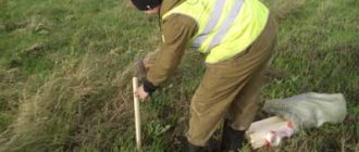
In the geodetic method, the expert directly goes to the site to inspect the territory, where, with the help of special geodetic instruments, he carries out the necessary measuring work.
The specialist enters all the information obtained during the study into a computer, where a three-dimensional model of the area under study is created.
The examination of a land plot is carried out in three stages:
- Preparatory – study of documentation and other information available for research about the site.
- Checking the territory using the geodetic method.
- The final stage or desk processing of the information received is the preparation of a report on the examination performed with detailed answers to the questions posed to the expert.
If in court during the consideration of the expert report any questions arise regarding the essence of the information contained in it, the judge may call the expert to give explanations. The parties to the dispute will be able to ask the expert questions that interest them.
Land management examination is carried out for a period of 1 to 3 months, depending on the complexity of the study.
Experts use the following as geodetic equipment:
- laser rangefinders;
- GPS navigators;
- tacheometers and theodolites;
- levels.
All equipment used during the study must be certified and meet the latest technical requirements.
When carrying out geodetic work, measurement accuracy, special care and extensive experience in conducting such examinations are required. An ordinary person without technical education cannot cope with such work.
In addition, the expert must have special expert education and be not just a good technical specialist, but an expert with a huge range of knowledge and skills. This is the only way to obtain a license for expert activities.
The received information is processed, as a rule, in the AutoCad computer program.
To conduct an examination, a specialist must provide the exact address of one or more disputed plots of land, their cadastral passports and title documents.
To carry out work, the expert company must have a license to carry out geodetic activities or be a member of the SRO.
How much does the examination cost?
The cost of the study depends on many factors, in particular, on the complexity of the work being carried out, on the remoteness of the site, and on the number of questions that need to be answered as part of the examination. Expert companies can set any competitive prices on the market for similar services.
Typically, conducting an examination costs 20-30 thousand rubles if you voluntarily invite an expert and independently select the applicant. Forensic examination usually costs a little more - about 40-45 thousand rubles.
Usually the court has its own close experts, with whom the courts regularly cooperate. These are exactly what the judge proposes when considering the decision to order research. The parties have the right to nominate their own experts.
What documents are needed?
In order to conduct an examination, you need to collect the necessary documents. The main list includes:
- Documents confirming the right to land (certificate of ownership, extract from the Unified State Register of Real Estate).
- Diagram from the BTI about buildings and their location.
- Cadastral passport.
- Results of land surveying.
- Permission from the authorities to use the land.
- Answer from Rosreestr.
Information about the land management examination carried out is entered into the cadastral register.
Regulation 214 “On the state examination of land management documentation” establishes a minimum period of work of 14 days. It will not be possible to conduct the research earlier than this period. In practice, this procedure usually takes much longer, which is why the judicial investigation is delayed.
Land management expertise allows you to establish the exact boundaries of land plots and resolve disputes regarding the ownership of land plots. The research is carried out by independent experts from geodetic companies, who can be involved in the dispute in court or voluntarily.
The procedure for conducting land management examination
The procedure depends on what tasks are assigned to the expert and the characteristics of the object to be examined. As a rule, land management examination contains several stages.
Preliminary
Here an agreement is signed with the client, specialists are initially familiarized with the technical specifications and information on the facility, the main direction of activity is determined and a list of works is drawn up.
Basic
- Documentary research of cadastral and title documents, in particular - technical passport, land survey, paper describing the procedure for using land, projects of communication and engineering systems, etc. Specialists study the documentation, assess the legality of the work, as a result of which it is possible to enter data into the register or exclude it from it, analyze the characteristics of the site.
- Field work, during which the features of the site are studied using special instruments - levels, GPS equipment, total stations, theodolites, laser range finders. During the work process, the following is determined: the area of the site as a whole or its parts;
- actual boundaries of private territory in kind;
- location of buildings on the site and near its boundaries.
LLC Expert
Conducting a land management examination is traditionally possible out of court, as well as within the framework of judicial proceedings.
Extrajudicial land management examination is carried out under an agreement between the customer (individual or legal entity, government agency) and the expert organization.
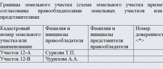
Judicial land management examination is carried out according to determinations of courts of general jurisdiction, arbitration courts and decisions of investigators. In this case, the expert must be warned (sign) about criminal liability under Article 307 of the Criminal Code of the Russian Federation for a knowingly false expert opinion. The court ruling on the appointment of a land management examination must contain the following information:
- location of the land plot;
- type of land management examination;
- information about the expert organization entrusted with carrying out the examination;
- questions for expert approval;
- deadlines for submitting an expert's opinion to the court (in the form of a time interval during which the examination must be carried out, or in the form of a date by which the opinion must be provided to the court).
Types of land management examinations:
- Expertise in drawing out the boundaries of land plots in situ
- Examination of land division
- Survey work
- Construction geodesy services
- Review of the expert's opinion on land management expertise
Questions that an expert must answer during a land management examination may be the following:
- What is the actual area of the land plots under study and does it correspond to the area reflected in the ownership documents?
- What are the actual boundaries of the land plots under study and does it correspond to the boundaries reflected in the land allotment documents?
- If the land plot under study does not have physical boundaries, is it necessary to remove the boundaries of the land plots on the ground?
- Establish the fact of overlapping boundaries of adjacent land plots;
- Establish the area of the established overlapping boundaries of adjacent land plots.
- Organize passage (travel) through the adjacent land plot;
- Propose options for dividing a common land plot in proportion to the shares in the ownership of the owners and taking into account the actual procedure for using the land plot;
- Determine the area of the land plot required for the full exploitation of the land plot and the buildings located on it that have a specific functional purpose, displaying the required boundaries on the plan;
- Determine what violations of special rules in the field of land management were violated;
- Establish the fact of the presence (absence) of displacement of the fence between adjacent land plots;
In addition, it is possible to review expert opinions for their reliability and validity, carried out by third-party expert institutions.
Traditional objects of land management expertise are:
- Land;
- Documents confirming ownership of the land plot;
- Orders of local government bodies on the allocation of land;
- Documents of the Bureau of Technical Inventory (BTI);
- Cadastral documents and land surveying.
The main, most typical tasks of land management examinations are:
- Expertise, analysis and research of land management documentation;
- Establishing the areas of disputed land plots, their actual boundaries on the basis of title documentation, as well as establishing their compliance with the data and other information specified in the state real estate cadastre;
- Division of a disputed plot of land between two or more owners;
- Establishing a procedure for the use of a disputed land plot, including the establishment of an easement;
- Establishing the compliance of a building (structure) located on your and neighboring territory with the requirements of technical regulations, current regulatory and technical documentation in construction, planning of urban and rural settlements, in terms of location relative to the border of the neighboring land plot.
Questions for land management examination:
- What is the actual area of the land plot under study?
- Does the actual area of the plot located at the specified address, determined during the examination, correspond to the area declared in the title documents?
- Is there an overlap between the boundaries of these land plots (with corresponding cadastral numbers)?
- Is the defendant’s property located on the plaintiff’s land plot (located at the specified address, having the specified area and cadastral number)?
- Does the actual location of the defendant's property in the area correspond to its location entered in the documentation?
- What are the geographic coordinates of the corner (turning) points of the land plot under study?
- What is the total area of the intersected parts of these land plots?
- What is the area of land free from development?
- What is the area of land occupied by buildings?
- What are the coordinates of the corners of the building located on the land?
- Is it possible to construct a real estate property on the land plot under study?
- What is the possible area of construction that can be erected on this plot of land?
- Do the land management work carried out on the study site comply with current legislation?
- Are special development rules observed when carrying out land management work on the land plot under study?
The cost of conducting an examination is from 10,000 rubles.
THE COST OF EACH EXAMINATION IS DISCUSSED AT A CONSULTATION.
EXAMINATION TIME IS FROM 5 TO 30 DAYS, SUPPORTING THE NECESSARY DOCUMENTS.
All experts and specialists of our organization have extensive experience in the field of forensic examinations and qualifications confirmed by certificates (certificates) for the right to perform them.
When appointing an examination in arbitration, criminal and civil cases, a forensic expert (state and non-state) is warned of criminal liability under Article 307 of the Criminal Code of the Russian Federation, and in administrative cases - Article 17.9 of the Code of Administrative Offenses of the Russian Federation is responsible for the disclosure of preliminary investigation data under Art. 310 of the Criminal Code of the Russian Federation.
As a full member of the NP “National Chamber of Forensic Expertise”, we are ready for constructive and fruitful cooperation in resolving disputes in administrative and economic conflicts and in legal proceedings.
We guarantee objectivity and efficiency of examinations.