The allocation of a site in kind is possible if its permissible area allows it. The location of the land and the specific order of its use matter. A share in a land plot is considered abstract, i.e. in nature it may not be determined. Situations are possible when the owner of a smaller share uses a larger part of the plot or even uses all the land himself.
Dear readers! The article talks about typical ways to resolve legal issues, but each case is individual. If you want to find out how to solve your particular problem , contact a consultant:
8 (800) 700 95 53
APPLICATIONS AND CALLS ARE ACCEPTED 24/7 and 7 days a week.
It's fast and FREE !
Co-owners can agree on the joint use of land, including by formalizing an agreement. But this may not always be beneficial.
Thus, there may be violations of the order of use, or one of the shared owners will want to sell his share. In such a situation, one of the owners turns to the other with a proposal to allocate a share. If he refuses the deal, he has the right to go to court and demand the compulsory allocation of the plot.
What it is?
The allocation is carried out at the request of one of the participants in shared ownership. The creditor of the shared owner of the land has the right to demand the allocation of a share in order to forcibly foreclose on it.
The participant in shared ownership sends to the co-owners of the plot a proposal to allocate a share. The written notification may contain the conditions of allocation - boundaries, area of the newly formed land plot.
The owner can also invite shareholders to directly determine the boundaries of his plot - with special signs. The allocation proposal specifies the desired time frame for obtaining consent and commencing work.
If other owners for any reason do not want the allocation, they have the right to submit their reasoned objections. If the owner evades the answer, the interested owner has the right to file a claim in court and demand the allocation of a proportionate plot.
A land management examination can be carried out, which will confirm or deny the possibility of allocating a plot in kind, without violating the rights of other owners and causing disproportionate damage to the original land plot.
The allocation of a land plot is the provision of a part of the land, a proportionate share of the owner who wants to isolate his part of the land.
It is carried out after the necessary land management work has been completed, the beginning of which must be an agreement between the owners or a court decision.
The newly formed land plot is subject to registration in the Unified State Register of Real Estate. Its cadastral registration is possible only after the boundaries have been determined, an address has been obtained, and land surveying has been carried out.
When forming a site, the opinions of other owners are taken into account. If there are objections and refusal to sign the agreement, the court will help allocate the shares.
If the allocation is of a commercial nature, then the owner should apply to the arbitration court at the location of the defendant.
Complex demarcation from the municipality
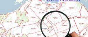
Since 2007, the definition and consolidation of plot boundaries has been regulated by Federal Law No. 221. Over the years of its existence, it has changed several times. There are currently provisions in place that allow cadastral work to be carried out free of charge. The new law is valid until 2020:
- when purchasing or concluding a rental contract after winning an auction (costs are reimbursed from the municipal budget);
- for complex activities covering a vast territory (it is called a cadastral quarter).
The state initiates land surveying in order to reduce the amount of unaccounted land and replenish the tax base. You can find out about events through:
- local media (district newspapers);
- district administration website;
- announcements at specially equipped stands;
- mailings from the commission to owners (only those whose addresses are available from specialists).
The owner, tenant or user of the allotment has the right to apply for a free determination of land boundaries. The state cadastral engineer, under one of the conditions, carries out land surveying free of charge:
- Lack of information in the Unified State Register of Real Estate, since the owner’s rights were formalized before 1998;
- Availability of data on the land plot in Rosreestr in the absence of a cadastral number. This happens if the procedure was carried out through the BTI before 2007. The plot was assigned only a conditional number;
- The cadastral registration procedure was not completed after the previously carried out land survey. It will be easier to restore the boundaries if the applicant still has the old technical plan in his hands;
- If there is an error in the register or cadastre.
Important! The costs of private surveying are not reimbursed by the municipality.
Disputes regarding complex work carried out are resolved in court or administratively. If the boundaries of the site were not agreed upon during the execution of the work, then within 15 years you can challenge the specialist’s decision. If you did not know about the upcoming complex measures, do not refuse this opportunity; the cadastral engineer will do all the work without payment. The owner will only need to submit papers and complete the registration of ownership.
Allocation of land
Allocation is possible by voluntary agreement between the owners. It is advisable to carry it out if the land plot is large - for example, intended for use for agricultural purposes, and the owners are actively developing it.
Allocation is permitted in the event that one of the owners wishes to sell their share.
The cost of a separate plot with its own cadastral number, as a separate piece of real estate, will be higher than the cost of the share.
The main condition is the possibility of allocating a site in kind depending on its parameters and location.
Actually
The allocation of a share involves the provision of its land equivalent in kind. The owner of the share must receive a full-fledged land plot. The process is easy to implement if the site is large and located in a convenient location.
A dispute may arise regarding how much of the site the owner needs to provide. Part of the land may be located near a pond, lake, or reservoir. This share may be higher in price.
If, after the allocation, it is planned to use water bodies that are located near the site and this can be done easily by providing a passage through the original site, then the owner of the allocated land may demand through the court to establish an easement - the right to limited use of the original land plot from which a share, for example, of a passage was separated or travel.
Read how to find out your turn on a plot of land. What is acquisitive prescription for a land plot? See here.
Shares
If the land plot is in common joint ownership, for example, by spouses or owners of a peasant farm, then they can sign a share agreement and divide the land into equal shares or establish another share ratio.
The shares will then not be allocated in kind, but at the same time the owners have the right to agree on the separation of the boundaries of specific shares and the formation of a land plot.
Differences from section
The allocation of a land plot from an existing plot is carried out without the termination of the existence of the original property. The old plot will also be considered an object of shared or individual ownership. He will be assigned the same cadastral number and will have the same address.
The changes will affect its area and boundaries, as well as the composition of copyright holders (owners).
When a plot is divided, the original plot ceases to exist and is transformed into several objects with their own new boundaries and cadastral numbers.
Procedure
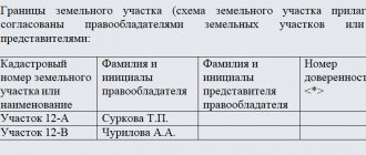
To allocate a plot of land, it is necessary to sign an agreement between the co-owners or go to court to force the procedure. The agreement must be certified by a notary. It can indicate the boundaries of the site and its area.
After carrying out land management work, changes or additions can be made to the agreement. Land management and cadastral work can be carried out before signing the agreement.
If the court decision is made in favor of a citizen or organization wishing to allocate their share, then all work must be carried out in the manner and within the time frame specified in the court decision.
What matters is the final court decision, i.e. the one that was adopted in the final instance where the case was considered.
If land management work has been completed, then you can contact Rosreestr with an application to register the newly formed plot for cadastral registration and register ownership.
List of documents
To allocate a share from a land plot to Rosreestr, you must provide:
- a copy of the applicant's passport;
- agreement between share owners or court decision;
- land management documentation – boundary plan, including those recorded on electronic media;
- title document for the original share;
- receipt of payment of state duty (2 thousand rubles).
If the applicant is acting under a power of attorney, then a notarized power of attorney confirming the citizen’s authority must be provided.
A sample boundary plan for a plot of land is here.
Statement
In 2020, the application is still completed on the form provided by Rosreestr. It is filled out by a specialist working with cadastral documentation.
The form contains information about the applicant, information about the share, location, and boundaries of the land plot. The applicant’s personal information is indicated - his passport details, contact information is indicated.
A sample application for the allocation of land is here.
Court decision on the allocation of a share of a land plot in kind in common shared ownership
- 13.02.2019
Judicial practice on the allocation in kind of a share of a land plot from common shared ownership
can be different.
There are prohibitions (norms) in the regions on the minimum size of land plots, less than which it is no longer possible to divide. Therefore, before filing a claim in court for the allocation in kind of a share in a land plot, you need to consult a lawyer for land disputes.
In the case below, experienced lawyer Yuri Anatolyevich Ushakov took part on the plaintiff’s side. The case was carried out brilliantly and won in full. Now our client can sell his plot or build a fence on it and begin construction and cultivation of his PERSONAL PROPERTY, and not the common shared one. A forensic land management examination was also carried out in the case.
. It is very important to ask the right questions to the experts.
Case No. 2-1379/20хх
Solution
In the name of the Russian Federation
May 30, 20xx, Moscow
The Shcherbinsky District Court of Moscow, composed of presiding judge Kudryashova I.S., with secretary Maleeva N.N., having considered in open court civil case No. 2-1379/xx on the claim of E. against PA, PS about the real division of land plots ,
INSTALLED
E. filed a lawsuit against PA., PS. on the allocation in kind of a share of a land plot.
In support of the stated requirements, pointing out that the decision of the Shcherbinsky District Court of Moscow dated December 12, 201 approved a settlement agreement between the parties, according to which 1/3 of the share in the ownership of a land plot with an area of 908 sq.m. became the property of the plaintiff. , with cadastral number 77:17:0120107:xxx, located at the address: Moscow, Sosenskoye village, Prokshino village, d.xx, and also 1/3 share in the ownership of a land plot with an area of 1142 became the property of the plaintiff sq.m., with cadastral number 77:17:0120107:xxx, located at the address: Moscow, Sosenskoye village, Prokshino village, xxx.
The ownership rights to the specified shares of land plots are registered with the plaintiff in the manner prescribed by law. The court also recognized the ownership of 1/3 of the land plots for each of the defendants.
Based on the above, taking into account the clarification, the plaintiff asks to summarize information about the ownership of E., PA, PS.
for land plots with cadastral numbers 77:17:0120107:xxx and 77:17:0120107:xxx. Carry out a real division and allocation of land plots E., PA., PS.
Allocate a plot of land with a total area of 683 sq.m., located at the address: Moscow, pos. Sosenskoye, Prokshino village. Select from property PA., PS. in equal share ownership of a land plot with a total area of 1367 sq.m., located at the address: Moscow, pos. Sosenskoye, Prokshino village.
Plaintiff E. did not appear at the court hearing about the day, time and place of the hearing in the case, he was duly notified, the valid reasons for his failure to appear in court are unknown, and he has a representative in the case.
Representative of the plaintiff , lawyer Ushakov Yu.A.
at the court hearing, he supported the stated claims based on the arguments set out in the claim, taking into account the clarification, and asked to satisfy them.
Defendants PA., PS. At the court hearing, the stated claims based on the arguments set out in the claim were supported and there was no objection to their satisfaction.
A representative of a third party of the Office of Rosreestr for Moscow did not appear at the court hearing about the day, time and place of the hearing in the case, he was duly notified, the valid reasons for the failure to appear in court are unknown, there were no applications to postpone the hearing of the case or to consider the case in his absence, due to with which, the dispute was considered in the absence of a representative of a third party, on the basis of Art. 167 Code of Civil Procedure of the Russian Federation.
Having listened to the explanations of the representative of the plaintiff and the defendants, having studied the arguments of the claim, and having examined the written materials of the case, the court finds the stated claims subject to satisfaction
, based on the following.
Possession, use and disposal of land and other natural resources, to the extent that their circulation is permitted by law (Article 129), is carried out by their owner freely, if this does not cause damage to the environment and does not violate the rights and legitimate interests of other persons (clause 3 Article 209 of the Civil Code of the Russian Federation).
Based on clause 2 of Article 218 of the Civil Code of the Russian Federation, ownership of property that has an owner can be acquired by another person on the basis of a purchase and sale agreement, exchange, donation or other transaction for the alienation of this property.
According to Article 252 of the Civil Code of the Russian Federation
, property in shared ownership can be divided between its participants by agreement between them.
A participant in shared ownership has the right to demand the allocation of his share from the common property. If the participants in shared ownership fail to reach an agreement on the method and conditions for dividing the common property or the allocation of the share of one of them, the participant in shared ownership has the right to legally demand the allocation in kind of his share from the common property.
By virtue of Art. 11.5 of the Land Code of the Russian Federation, the allocation of a land plot is carried out in the case of the allocation of a share or shares from a land plot that is in shared ownership. When a land plot is allocated, one or more land plots are formed. In this case, the land plot from which the allocation was made remains within the changed boundaries (changed land plot).
When a land plot is allocated, a participant in shared ownership, upon whose application the land plot is allocated, acquires ownership of the resulting land
plot
and the said participant in shared ownership loses the right of shared ownership in the changed land plot. Other participants in shared ownership retain the right of shared ownership of the changed land plot, taking into account the changed size of their shares in the right of shared ownership.
As established at the court hearing, the ruling of the Shcherbinsky District Court of Moscow dated December 12, 201 approved a settlement agreement between representative E., as well as PA. and PS., in accordance with which they acquired 1/3 of the ownership rights to a land plot with an area of 908 sq.m., with cadastral number 77:17:0120107:xxx and a land plot with an area of 1142 sq.m. , with cadastral number 77:17:0120107:xxx, located at the address: Moscow, pos. Sosenskoye, Prokshino village, xx, in the ownership of PA and PS. the right to a residential building was also transferred, according to
1/3 of each.
According to the conclusion of the land management examination carried out in the case
, land plots with cadastral numbers 77:17:0120107:xxx and 77:17:0120107:xxx are located in a single fence, their total area is 2279 sq.m. Due to the fact that there is no internal adjacent border between land plots with cadastral numbers 77:17:0120107:267 and 77:17:0120107:xxx, it is not possible to determine the actual boundaries of these land plots separately. According to information from the public website Rosreestr, catalogs of coordinates of corner and turning points of these land plots are present in the Unified State Register of Real Estate. The actual boundaries of the common land plot do not correspond to the boundaries of land plots with cadastral numbers 77:17:0120107:xxx and 77:17:0120107:xxx according to the USRN, based on this, further research by the expert was carried out according to the boundaries of the disputed plots registered in the USRN: area of the land plot with cadastral number 77:17:0120107:xxx is 1142 sq.m.; the area of the land plot with cadastral number 77:17:0120107:xxx is 908 sq.m.; the parties' shares in the specified land plots are equal, 1/3 shares each. For the share of E. (1/3), the area of the allocated land plot will be 683 sq.m., for the shares of PA and PS (2/3), the area of the allocated land plot will be 1367 sq.m.
During the survey, the parties to the case proposed the option of dividing the specified land plots. Taking into account the current situation, as well as according to the opinions of the parties, the expert developed an option for reorganizing land plots
with cadastral number 77:17:0120107:xxx (area 1142 sq.m.) and with cadastral number 77:17:0120107:xxx (area 908 sq.m.). Also, when developing the option, the expert took into account the location of the residential building, the owners of which are PAs. and PS for 1/3 share.
According to the option, the expert proposed to identify land plots:
| 77:17:0120107:xxx, with a total area of 1367 sq.m. in the following coordinates Turning and corner points of land plot E. 77:17:0120107:xxx with an area of 683 sq.m. | ||
| 1 | -10030.51 | -4136.08 |
| 2 | -10045.36 | -4117.10 |
| 3 | -10048.65 | -4112.42 |
| 21 | -10067.51 | -4125.76 |
| 8 | -10061.39 | -4134.14 |
| 9 | -10050.82 | -4149.26 |
| 10 | -10036.62 | -4139.24 |
| 11 | -10035.62 | -4139.87 |
| 12 | -10033.15 | -4138.35 |
| 1 | -*10030.51 | -4136,08 |
| Turning and corner points of the land plot PA and PS 77:17:0120107:xxx with an area of 1367 sq.m. | ||
| 3 | -10048.65 | -4112.42 |
| 4 | -10053.80 | -4105.71 |
| 5 | -10054.21 | -4105.99 |
| 6 | -10055.18 | -4104.60 |
| 13 | -10055.78 | -4103.74 |
| 14 | -10059.60 | -4097.85 |
| 15 | -10066.07 | -4089.00 |
| 16 | -10076.03 | -4076.29 |
Ershov S.B. - with cadastral number 77:17:0120107:xxx, with a total area of 683 sq.m.;
PA. and PS - with cadastral number
| 17 | -10085.29 | -4063.87 |
| 18 | -10102.87 | -4078.96 |
| 19 | -10098.91 | -4083.74 |
| 20 | -10075.49 | -4114.84 |
| 7 | -10073.09 | -4118.12 |
| 21 | -10067.51 | -4125.76 |
| 3 | -10048.65 | -4112.42 |
The expert explained that to implement this option, it is necessary to oblige the cadastral registration authorities to make changes to the information about the location and area of the land plot with cadastral number 77:17:0120107:xxx (set the area to 683 sq.m. and coordinates according to table No. 4), and It is also necessary to oblige the cadastral registration authorities to make changes to the information about the location and area of the land plot with cadastral number 77:17:0120107:xxx (set the area to 1367 sq.m.).
The expert also explains that for a land plot with cadastral number 77:17:0120107:xxx (1367 sq.m.), allocated to the ownership of PA and PS, the following share ratio is established:
– PA – 1/2 share
— PS – 1/2 share.
The Court has no reason not to trust the expert’s conclusion; the expert has been warned of criminal liability for giving a knowingly false conclusion; the expert has the appropriate qualifications.
The parties at the hearing agreed with the option proposed by the expert.
Having analyzed and assessed the evidence collected in the case in its entirety, taking into account the recognition of the claims by the defendants, the court comes to the conclusion that the claims are subject to satisfaction.
Based on the above, guided by Articles 194-199 of the Code of Civil Procedure of the Russian Federation, the court
DECIDED:
E.’s claims against PA, PS regarding the real division of land plots are satisfied.
Carry out a real division of land plots with cadastral numbers 77:17:0120107:xxx and 77:17:0120107:xxx between E, PA and PS.
| Allocate to property Eland plot with cadastral number 77:17:0120107:xxx, with a total area of 683 sq.m., located at the address: Moscow, Sosenskoye village, Prokshino village within the boundaries of: Turning and corner points of the land plot E.. KN 77:17:0120107:xxx with an area of 683 sq.m. | ||
| 1 | -10030.51 | -4136.08 |
| 2 | -10045.36 | -4117.10 |
| 3 | -10048.65 | -4112.42 |
| 21 | -10067.51 | -4125.76 |
| 8 | -10061.39 | -4134.14 |
| 9 | -10050.82 | -4149.26 |
| 10 | -10036.62 | -4139.24 |
| 11 | -10035.62 | -4139.87 |
| 12 | -10033.15 | -4138.35 |
| 1 | -10030.51 | -4136.08 |
Allocate to the shared ownership of PA and PS, 1/2 share of each, a land plot with cadastral number 77:17:0120107:xxx, with a total area of 1367 sq.m.,
| located at the address: Moscow, Sosenskoye village, Prokshino village within the boundaries of: Pivot and corner points | and PA land. and PS 77:17:0120107:xxx with an area of 1367 sq.m. | |
| 3 | -10048.65 | -4112.42 |
| 4 | -10053.80 | -4105.71 |
| 5 | -10054.21 | -4105.99 |
| 6 | -10055.18 | -4104.60 |
| 13 | -10055.78 | -4103.74 |
| 14 | -10059.60 | -4097.85 |
| 15 | -10066.07 | -4089.00 |
| 16 | -10076.03 | -4076.29 |
| 17 | -10085.29 | -4063.87 |
| 18 | -10102.87 | -4078.96 |
| 19 | -10098.91 | -4083.74 |
| 20 | -10075.49 | -4114.84 |
| 7 | -10073.09 | -4118.12 |
| 21 | -10067.51 | -4125.76 |
| 3 | -10048.65 | -4112.42 |
The right of shared ownership between E, PA and PS is terminated.
The court decision is the basis for making changes to the information of the state real estate cadastre about the location and area of a land plot with cadastral number 77:17:0120107:xxx and a land plot with cadastral number 77:17:0120107:xxx, as well as for registering ownership rights for Ershov Sergei Borisovich, as well as PA and PS for the specified land plots.
The decision can be appealed on appeal to the Moscow City Court through the Shcherbinsky District Court of Moscow within a month from the date the court decision was made in final form
Judge I.S. Kudryashova
The decision came into force on July 10, 201x.
CONCLUSION:
If you have a share in a land plot, then you will agree that it is practically impossible to sell it, but if you allocate this share in kind, its value will be market value and
you will be able to sell it regardless of other owners.
Therefore, make a decision on dividing the common shared ownership of the land plot right now and allocate yourself a share in kind!
Sign up for a consultation now.
We are waiting for your call!
Price
Land management work is subject to payment, the cost of which averages 5-20 thousand rubles. The state duty is 2 thousand rubles.
The average cost of work excluding legal costs is 25 thousand rubles.
The procedure for registering a residential building on a land plot is determined by current legislation. Is it possible to sublease part of the land plot? Information here.
How to find out who is the owner of a land plot? Details in this article.
Arbitrage practice
When considering claims for the forced allocation of a share from a land plot, the courts take into account the results of the land management examination and establish the real possibility of allocating the plot in kind, without causing disproportionate damage to the original plot.
If the possibility of separation is established and the plaintiff can confirm his ownership of the share, then, with a high probability, claims of this kind in Russian courts will be satisfied. In such litigation, it is advisable to seek the support of a qualified lawyer.
Here is presented the judicial practice on declaring the allocation of land plots illegal.
Disputes with neighbors
Before establishing boundaries in the area, notify your neighbors about the date and time of work in one of the following ways:
- through social networks;
- personally;
- by phone;
- by registered mail with notification.
The latter option is preferable, since you will have proof of receipt of the letters. In SNT it is necessary to invite the chairman to the land surveying procedure. During the work, the owner of the site and his neighbors need to sign an agreement on the boundaries. Refusals are also documented. Before going to court, try to find a compromise solution - delimit the space so that the position of the fence suits all owners.
If no one wants to make concessions, then the dispute is resolved in court. Before considering your claim, you must:
- obtain an extract from the Unified State Register for your own and neighboring plots;
- find out the boundaries of environmental protection zones;
- obtain documentation for nearby power lines;
- make copies of archival documents, compile a history of your own site.
If you have the means, you can immediately conduct a land survey. It costs 40-50 thousand rubles. The judicial review of the dispute can last more than one month. Only after receiving the final decision and its entry into force can a cadastral passport of the land plot be issued.