Didn't find the answer to your question? Find out how to solve exactly your problem - call right now: +7 (Moscow) +7 (St. Petersburg) It's fast and free!
There are no abandoned lands in the Russian Federation. If a territory has no owner, it belongs to the state. Recently, information about all plots and their owners is contained in a single database - EGRN (formerly GKN).
Since 2008, in connection with the systematization of information, such a definition as “previously recorded land” has appeared. What it means and what features it has, you will learn from this article.
The status of a land plot is “previously registered” - what does this mean?
Each property must have strictly defined boundaries and be registered with the Unified State Register of Real Estate, however, the systematization of data on plots and their owners began relatively recently - after the adoption of Federal Law No. 221 of July 24, 2007 .
Due to changes in legislation, a new classification of land has appeared.
Based on the nature of the information contained about the property in the Unified State Register of Real Estate, the following types of plots are distinguished:
- temporary;
- archival;
- taken into account;
- canceled;
- previously taken into account.
The territory registered before the entry into force of Federal Law No. 221 has the status of previously registered land. This category also includes plots for which ownership rights arose and were successfully registered before March 1, 2008.
Thus, it is not uncommon for the owner of a property to contact Rosreestr for the first time, and a government agency employee informs him that the site has already been registered previously.
The main characteristics of this status of real estate are contained in Article 69 of Federal Law No. 218 of July 13, 2015.
How to correct a cadastral error
The article will discuss how to legally correct a cadastral error consisting of crossing (overlapping) the boundaries of neighboring land plots.
The relevance of this topic is connected with two circumstances
The first is that until mid-2001, i.e., before the Federal Law “On Land Management” came into force, land plots were provided to land users without the obligatory precise determination of their coordinates.
Over the past ten years, Russia has been in the process of registering plots of land for a single cadastral register, as a result of which, in practice, more and more legal disputes arise regarding the crossing of the boundaries of neighboring land plots.
Such an intersection, which is a type of cadastral error, creates uncertainty in the question of which land plot this or that territory belongs to and, therefore, must be corrected.
The second circumstance is that in the event of a dispute between neighboring landowners about how exactly and at the expense of which plot the cadastral error should be corrected, the norm of Part 4 of Art.
28 of the Federal Law “On the State Real Estate Cadastre” (hereinafter referred to as the Federal Law “On the State Property Committee”), according to which a cadastral error can be corrected based on a court decision.
At the same time, the current legislation does not answer the questions: what exactly should the correction of a cadastral error consist of, how to prove a cadastral error, who is the plaintiff and defendant in a claim for correction of a cadastral error, how to formulate claims.
The judicial practice emerging in this category of cases is unstable and contradictory; There is often confusion about the question of how a claim to correct a cadastral error differs from other methods of protecting rights. In addition, it is also worth saying about the most common risk today of refusal to correct a cadastral error and the way to overcome it. It is these questions that will be further explored in the article [1].
What should the correction of a cadastral error consist of?
The Federal Law “On the State Property Committee” does not say anything about what the correction of a cadastral error should consist of. In judicial practice, there are two methods of correction.
1. The first is based on Part 3 of Art.
25 of the Federal Law “On the State Property Committee”, according to which during cadastral registration in connection with the clarification of part of the boundaries of a land plot, which is also part of the boundaries of another land plot, the cadastral registration authority simultaneously makes appropriate changes to the information entered into the State Property Committee on the location of the boundaries of such an adjacent land plot.
That is, correcting the cadastral error should consist of adjusting the coordinates of the characteristic points of the neighboring land plot in the State Property Committee so as to “cut off” its boundaries along the boundaries of the previously registered plot.
In one of the cases, satisfying a claim to correct a cadastral error, the court ordered the cadastral chamber to correct the cadastral error by clarifying the boundaries of the land plot with cadastral number ...2198, owned according to a state act by the entrepreneur (plaintiff), in accordance with the submitted boundary plan and making appropriate changes along the boundaries and area of a land plot with cadastral number 23:49:0136003:1536, owned by the right of permanent (perpetual) use to the company (defendant)[2].
2. The second method, in its logic, comes from clause 2, part 2, art. 26 of the Federal Law “On the State Property Committee”, according to which the implementation of cadastral registration is suspended, including in the event that one of the boundaries of the land plot for which an application for cadastral registration is submitted, in accordance with cadastral information, crosses one of the boundaries of another land plot.
If the cadastral chamber, contrary to this norm, puts a plot of land on cadastral registration with the intersection of its borders with another plot, then if the court recognizes the actions of the cadastral chamber as illegal, the information in the State Property Committee must be brought to the original position that existed before the cadastral chamber committed this violation.
Since before the violation the second plot was not registered in the cadastral register, the correction of the cadastral error should consist of deregistration of the land plot (cancellation of information about it in the State Property Committee).
In one of the cases, the court considering a dispute over the correction of a cadastral error indicated that “land plots with cadastral numbers: ... 299, ... 300 have boundaries that cross the boundaries of an adjacent land plot, in particular, the boundaries of a previously registered land plot with cadastral number ... 6, which was discovered by the cadastral chamber only after the cadastral registration of these land plots, therefore, the State Property Committee lawfully canceled the record of real estate objects in order to eliminate the overlap of the boundaries of the above plots”[3].
In judicial practice, without reference to Part 2 of Art.
25 of the Federal Law “On the State Property Committee”, an understanding of the possibility of correcting a cadastral error in the form of removing a site from cadastral registration occurs in the case when a cadastral error cannot be corrected by adjusting the boundaries of an erroneously registered site, for example, if a new site is completely within the boundaries of a previously registered one plot[4]. In one of the cases, the court stated the following: “When drawing up an act of approval of the boundaries of a land plot with cadastral number ... 860, carried out during the state examination of land management documentation, it was established that land plots with numbers ... 997 and ... 998 (the area of the geodetic overlay is 997 sq. m and 50 sq. m, respectively) were fully included in the land use of the plot with cadastral number 23:49:0132007:860, owned by the company. In this regard, the court rightfully ordered the Federal State Institution "Land Cadastral Chamber" in the Krasnodar Territory, authorized to enter information about a land plot into the State Property Committee and remove real estate from the cadastral register, to make the necessary corrections to the information of the State Property Committee and remove land plots with cadastral numbers from the cadastral register …997, …998”[5].
It is necessary, however, to take into account that such a result of correcting a cadastral error, such as deregistration of a plot, does not correspond to Part 2 of Art.
25 of the Federal Law “On the State Property Committee”, according to which the cadastral registration authority deregisters a land plot only if such land plot is a converted piece of real estate and is subject to deregistration in accordance with the specifics of cadastral registration established by Article 24 of the Federal Law “On the State Property Committee” formation of real estate objects.
Judicial practice knows cases of refusal to correct a cadastral error in the form of deregistration of a plot.
In one of the cases, the court indicated that the legitimate interest of the plaintiff was violated not by the fact of registration of the federal right of ownership and the right of permanent (perpetual) use of the land plot, but by the incorrect registration of the plot with the cadastral register as a result of a cadastral error during land surveying, displacement of the land plot from the cadastral number ...170 for a land plot with cadastral number ...312. Requirements aimed at the destruction of a land plot at the federal level of ownership and termination of the right of permanent (perpetual) use were left unsatisfied, since they are not appropriate ways to protect the violated interest of the plaintiff[6].
How to prove a cadastral error?
Our analysis of judicial practice indicates that a significant part of refusals in claims to correct cadastral errors is caused by the lack of proof of the fact of the error itself. The courts believe that the mere contradiction between the coordinates of characteristic points indicating the intersection of the boundaries of neighboring areas is not enough.
How to prove an error based on the requirements that judicial practice places on evidence? The key evidence is the boundary plan of the site, during the registration of which a cadastral error was made. This document is mandatory when carrying out cadastral registration (clause 2, part 1, article 22 of the Federal Law “On the State Property Committee”).
The point of its preparation is that when intersections of plot boundaries occur, the cadastral chamber does not have information about which of the boundary documents (in relation to previously registered plots or those registered by the applicant) contains an error.
This can only be revealed by a cadastral engineer when performing cadastral work, the result of which is precisely the boundary plan.
In addition, plaintiffs, in order to eliminate the court’s doubts about the validity of the conclusions contained in the boundary plan, sometimes ask the court to order a judicial land survey examination on the presence or absence of the fact of crossing the boundaries of the plots and the reasons for such crossing.
However, at the same time, the courts impose the same requirements on the boundary plan and expert opinions in terms of the information that should be contained in them.
Thus, the boundary plan must include the conclusion of a cadastral engineer, which, like an expert opinion, must contain the following information: (1) the results of geodetic measurements, allowing the cadastral chamber to determine the possible reasons for the intersection of plot boundaries, (2) corrected values of the coordinates of characteristic points boundaries of land plots[7], (3) information about what exactly the cadastral error is expressed in, with justification for classifying the relevant information as erroneous[8], (4) the area of overlap[9].
An approximate wording contained in the conclusion of a cadastral engineer may look like this: “When carrying out cadastral registration of a land plot belonging to NN (cadastral number N), the cadastral engineer made a cadastral error when preparing the boundary plan of plot N, since the border of land plot N is at points 5-3 (drawing No. 1 of the expert report) crosses the boundaries of the land plot owned by the plaintiff (cadastral number F) at points 7-9, resulting in an overlap of land plots with an area of L sq.m. (option: passes through a building owned by the plaintiff, and therefore part of the foundation ended up on land plot N).
Who are the plaintiff and defendant in a claim to correct a cadastral error?
Any interested person can be a plaintiff in a request to correct a cadastral error (Part 5, Article 28 of the Federal Law “On the State Property Committee”).
The defendants in a claim to correct a cadastral error are: (1) the owner of the land plot, at whose expense the boundaries of the plaintiff’s land plot can be restored[10], (2) the tenant of the plot, if the plot is in state or municipal ownership and leased to a period of more than five years, (3) the cadastral chamber, since it is it that must carry out the actions for cadastral registration of the new boundaries of the land plot[11], (4) other persons whose rights may be affected by the correction of the cadastral error[12],
How to formulate claims?
Since the correction of a cadastral error, as a general rule, consists of cadastral registration of a land plot in the form of adjusting its boundaries, the claim should be formulated approximately as follows: “to correct a cadastral error by changing the boundary of a land plot with cadastral number ... 0340 in part from point 794 to point 795 and from point 795 to point 796, forming it along a new border from point 794 to point H1, from point H1 to point 795, from point 795 to point H6, from point H6 to point H5, from point H5 to point H7 , from point H7 to point 796 (coordinates of points 794, 795, 796 are taken from the cadastral extract dated 10/05/2011 No. 5520/202/11-2278 about a land plot with cadastral number ...0340; coordinates of points H1, H5, H6, H7 are obtained as a result of cadastral work carried out by cadastral engineer A.V. Popov and are contained in the boundary plan to clarify the boundaries of the land plot with cadastral number ...0036”[13].
In some cases, plaintiffs supplement this requirement with a requirement that the owner of a plot registered with a cadastral error must contact the cadastral chamber with an application for cadastral registration of this plot due to the need to clarify its boundaries.
In satisfying this requirement, the courts motivate it by the fact that if there is an application from the owner of the property to correct a cadastral error and documents containing information in the amount necessary to make these corrections, the cadastral registration authority makes a decision to eliminate such an error, taking into account the requirements of Part 5 Art.
28 Federal Law “On the State Property Committee” and the letter from Rosnedvizhimost “On the preparation of documents for the purpose of ensuring the maintenance of the state real estate cadastre” dated March 4, 2008.
No. VK/0877$ jhowever, taking into account the refusal of the owners of neighboring land plots to apply for the correction of a cadastral error, the appropriate method of protection is to require the owners of neighboring plots to correct a technical error made during the cadastral registration of their land plots[14] .
Source: //www.kazan-yurist.ru/index.php/2013-11-03-10-09-18/kak-isprivit-kadastrovuy-oshibku
Features of previously registered lands
During the Soviet era, the land did not have clearly defined boundaries, because land surveying was not carried out. Although the systematization of data on plots began several years ago, in practice there are still cases when the owner of the property has title documents in hand, but there is no information about the land in the Unified State Register of Real Estate (formerly the State Property Committee) database.
This situation can be corrected. The owner of the property must contact any branch of Rosreestr with a written application to enter information about the site into a unified data system.
If this land does not have clearly defined boundaries, the citizen will first need to call a specialist to carry out cadastral work and land surveying.
Entering information about a site into the Unified State Register of Real Estate is carried out exclusively at the request of a citizen. Government agencies are not required to initiate this process.
Useful material : Categories of land and type of permitted use.
Exclusion of an entry from the Unified State Register - consequences, procedure for 2020
Real estate objects may undergo changes or cease to exist altogether, as a result of which the data in the Unified State Register loses its relevance and does not correspond to reality. For such cases, a procedure is provided for deregistration of a property.
Excluding information about an object from the Unified State Register is the reverse process of its establishment.
Carried out in the following cases:
- liquidation of the facility;
- missing the deadline for registering rights to the object.
Deregistration of a real estate property is carried out by the same body that registers it - Rosreestr.
Legislation
When an object is deregistered, data about it is excluded from the register on the basis of:
What is the base
Unified State Register of Real Estate – database of information about real estate. This information resource functioned until the end of 2019 from the new year 2017 this database was reorganized into the Unified State Register of Real Estate, the essence of which has not actually changed, but the databases of the Cadastral Service and Rosreestr have merged.
The roster consisted of:
- paper and electronic documents;
- affairs;
- a system of records in a certain form in accounting books, which were carried out by state registrars.
This register contained the information:
- about existing and already terminated rights to real estate;
- objective data characterizing each registered property;
- about persons who have rights to registered objects;
- about existing encumbrances of the object, including arrests, etc.
Information from the database is mostly available to everyone. They are not equated to state secrets, therefore, at the request of both an individual and a legal entity, they are provided on a reimbursable basis to a certain extent within the framework of current legislation.
The Federal Service for State Registration, Cadastre and Cartography, or simply Rosreestr, is responsible for issuing information from the database.
The database is maintained through the registration of rights to real estate, including transactions with it.
Registration itself is not mandatory and is carried out on the declarative principle, but at the legislative level, individual cases link the moment of emergence of the right to real estate with the moment of registration of rights to it.
What information can be obtained from the extract?
The amount of information provided in the extract from the Unified State Register may vary. It all depends on what form is required and who is applying for it.
- Most often, an extract of form No. 1 (general information) is issued. Any applicant, even those who do not have any rights to the object, has the right to receive such an extract upon application.
The extract information is publicly available and relates to: specific real estate and its characteristics, the owner of the real estate, the scope of his rights, including current encumbrances and restrictions on rights. - Form No. 2 (extended) - more informative due to the content, in addition to the data reflected in Form No. 1 , also identification data of the owner, information about the established legal restrictions is reflected in more detail ( for example , when property is seized, it is indicated by whom it was imposed, when and on what grounds) .
The list of recipients of such an extract is limited and includes only the owner, his authorized representative, an official of a government agency (court, notary, etc.). - Form No. 3 duplicates the documents by which the owner is vested with rights in relation to the real estate.
An extract is requested to restore the original title documents that were lost, damaged, etc. Only the owner, his authorized representative, or an official of a government agency (court, notary, etc.) are also entitled to receive such an extract.
It is also possible to issue forms in which:
- consistently contain information about each fact of transfer of rights to a real estate object and the persons who at one time or another had the right to the object;
- with information regarding the owner’s status as incapacitated or partially capable;
- with information about each person requesting information from the Unified State Register on the property.
When to exclude
Removing an object from the registry consists of two aspects:
- legal
- actual.
- Actual is the reason and presupposes the cessation of existence of the property (demolition of a house, etc.).
- Legal is the basis and presupposes the presence of a document certifying the fact of the termination of the object’s existence (an inspection report by a cadastral engineer, a court decision).
Arbitrage practice
Some cases require a court decision, on the basis of which the object or rights to it will be excluded from the database. Such situations are resolved in lawsuit proceedings, since there are disputes about the law.
A claim for exclusion of an entry from the Unified State Register and its sample can be found freely on the Internet or you can contact an experienced lawyer, which will entail additional costs. In addition, an example can be found here.
Based on judicial practice, the bulk of cases in this category are cases of:
- the need to exclude information about the right of a person; Most often, such a claim recognizes the transaction as invalid, and the rights of the previous copyright holder are restored.
- the need to exclude information about the object due to its demolition. This situation occurs during unauthorized construction. Simultaneously with this decision, the issue of demolition of the building is being resolved.
Grounds for the application
An application from the owner, his representative, or the liquidated property is submitted when the appropriate supporting documents are available.
An application for deregistration of a real estate property is accompanied by an inspection report - a document with which the cadastral engineer, having examined the location of the property to be deregistered, will attest to the fact of its termination.
The form of the act and other aspects of its preparation are fixed by the order of the Ministry of Economic Development of December 13, 2010 No. 627 “On approval of the form of the inspection report and the requirements for its preparation.”
an example document here.
Consequences of exclusion of real estate from the Unified State Register
Deregistration of a specific property neutralizes the owner’s rights to this property. In fact, if there is no object, there are no rights to it.
Don’t know how to access the USRN database? Read here.
With the exception of information about a property from the database, access is carried out in the same way as its registration. The owner or a person authorized by him applies to Rosreestr with an application to deregister the property and attaches a modest package of documents.
Such an act can be drawn up only after a cadastral engineer has visited the place where the property was previously located. This is done in order to verify the fact that the object has ceased to exist.
A number of cases, as a rule, concerning transactions carried out in violation of the law (fraud by one of the parties to the transaction, etc.), information from the Unified State Register is excluded after a court decision has entered into force.
In this case, the object does not actually cease to exist, but the person’s rights to the object cease to exist. In this way, the original position before the transaction is restored, aimed at restoring the rights of the injured party.
Online submission of an application to deregister an object from the database is not provided for by law.
Source: //prosud24.ru/iskljuchenie-zapisi-iz-egrp/
Features of entering information about a site into the state cadastre
So, we figured out what the status of a previously registered land plot means. Particular attention should also be paid to the process of entering information about a property into the Unified State Register of Real Estate.
If information about the land is not contained in the state system, the owner will not be able, if necessary, to order an extract from the Unified State Register of Real Estate.
This document confirms that the citizen has ownership rights to the plot, contains its detailed characteristics and a list of all owners. Most often, it is required when applying to a bank and government agencies, as well as when alienating an object.
The procedure for entering information about land into the USRN database is as follows:
- collection of documentation for the site;
- filling out an application form for entering information about an object into the system;
- provision of these papers to the Rosreestr branch;
- receiving an extract from the Unified State Register of Real Estate (it confirms that information has been entered into the database).
If a citizen has provided an incomplete set of documentation, a Rosreestr employee has the right to refuse to accept the application. In addition, the grounds for refusal may be the presence of errors in the request form, the lack of clearly defined boundaries of the land, or the presence of a land dispute with neighbors (owners of adjacent plots).
You can contact Rosreestr again after correcting the problem that caused the refusal.
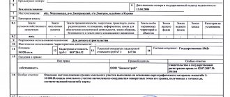
Information about the property has an up-to-date status
- Section 1: “Information about the main characteristics of the property”,
- Section 2: “Information about registered rights”,
- Section 3: “Description of the location of the land plot”,
- Section 4: “Description of the location of the property”,
- Section 5: “Plan of the location of the premises, parking spaces on the floor (floor plan).”
What does it mean that the status of a land plot is temporarily certified?
Hello, “Current uncertified” is information about the characteristics of a real estate property that are included in the state real estate cadastre and in respect of which changes have not been made to the Unified State Register due to the need to comply with the requirements established by the legislation of the Russian Federation for their change and the absence of such confirmation, the status is assigned ( in accordance with clause 179 of Order of the Ministry of Economic Development of Russia dated December 16, 2020 N 943 “On establishing the procedure for maintaining the Unified State Register of Real Estate, the form of a special registration inscription on a document expressing the contents of a transaction, the composition of information included in a special registration inscription on a document expressing the contents of a transaction , and the requirements for its completion, as well as the requirements for the format of the special registration inscription on the document expressing the contents of the transaction in electronic form, the procedure for changing in the Unified State Register of Real Estate information about the location of the boundaries of a land plot when correcting a registry error").
The process of land management work will not take much time. As a rule, cadastral engineers carry out such procedures within 10 – 14 days. At the same time, do not forget that at least a month before the start of the event, you must notify the owners of neighboring plots about this. Therefore, the land survey will be completed in approximately one and a half months (if everything is done correctly and the Rosreestr body does not return the documents for corrections).
Based on the foregoing, we can proceed to defining the types of land plots that are usually identified with a certain group of target lands. In general, by default it is assumed that land in the country is state-owned; only after being allocated to a specific category is it divided into plots determined by laws and authorities into municipal and private ownership. Taking into account the existing classifications of the intended purpose of land, there are categories:
Accounted status
This is also possible if land ownership is the property of the state or municipality before boundary work is carried out and the lease right to at least one formed plot of such objects is registered. If you have a document for such an allotment, but there is no information about it in the cadastre, contact the competent authorities to enter it.
— expiration of the “temporary” status of the State Property Committee information and failure to receive documents containing information about registered rights to the property or restrictions (encumbrances) of rights to it within the specified period;
Restriction of rights and encumbrance of a property is
Among the restrictions mentioned, attention should be paid to the seizure of property, which can be considered as a restriction in its pure form. Seizure of property means a prohibition to dispose of property (that is, sell it, exchange it, donate it, transfer it for payment of rent, transfer it as collateral, lease, trust management, etc.). It is used by the court as a measure to secure a claim in the forced execution of court decisions, as a way to ensure the execution of a decision to collect a tax, by an investigator in order to secure a civil claim or possible confiscation of property.
The restrictions on real rights provided for in the Law on State Registration of Rights to Real Estate and Transactions with It have a different legal nature. Thus, an easement is a limited property right, a mortgage is a way to ensure the fulfillment of obligations, lease and trust management are contractual obligations. It should be borne in mind that the registration of such real estate transactions as rent or mortgage is legally equivalent to the registration of encumbrances with the same name of the property rights of the owner or subject of economic management rights, and the registration of an easement as a property right is at the same time the registration of an easement as an encumbrance.
More to read: Benefit for Living in the Chernobol Zone Ryazan Sapozhok
Encumbrances on ownership of an apartment
As for unregistered encumbrances and the possible existence of third party rights to the apartment, this is more difficult to detect. The buyer will have to understand the title documents, go through all the stages of preparing the transaction and make sure of the “legal purity” of the purchased apartment. There is a detailed one for this . Opens in a new tab.”>STEP-BY-STEP INSTRUCTIONS .
- The seller of the apartment has not yet paid off the mortgage loan for it, and is selling it along with the debt and collateral (encumbrance);
- The buyer bought the apartment in installments (until the full amount is paid, the apartment is pledged to the Seller);
- The apartment is sold together with the tenants living in it under a lease agreement (the Buyer takes the place of the lessor);
- The apartment is sold encumbered with rent (the Buyer takes the place of the rent payer, with the consent of the rent recipient).
27 Jun 2020 stopurist 756
Share this post
- Related Posts
- Definition Young Family
- The bailiff filed a lawsuit against the debtor and can recover 1/4 of the land plot.
- Providing Housing for Employees of the Ministry of Internal Affairs with Large Children Currently in Tver
- Sample property division agreement after divorce