All articles
6138
2020-03-13
If, after maintaining the cadastral number, the information is not displayed on the local coordinate system, you need to analyze the reasons and eliminate the consequences. The material presented will tell you what to do, why the land plot is not on the cadastral map.
Registration authority experts understand why a public cadastral map
, what information is available using it. EGRN statistics for 2020 provide the following information:
- The registered amount is 70.3 million.
- Displayed on the cadastral map – 61%.
The registration authority informs the owners: if the entity receives a tax notice annually, the land plot has a cadastral number, there is no guarantee that the land asset will be displayed on the map.
What does the cadastral map show?
Why is a public cadastral map of Rosreestr needed - to display land plots with clearly defined boundaries. If the asset is included in the USRN database and has a clearly marked line, the site will be displayed on the map.
Having purchased a land plot, the owner is obliged to register it - to register the plot with the cadastral register. To register, the engineer carries out land surveying, determining the boundaries and compliance with the documentation. This procedure has been mandatory since 2001; each land must have coordinates and a line.
If the owner knows the cadastral number, he can check the boundaries of the land asset using a specialized service. By entering the code, the following information will become available:
- Category of land.
- Full address of the site location.
- Total area.
- Land surveying (carried out or not).
If land surveying has not been carried out, the “Line Surveying” block will display information highlighted in red with the following content: land surveying has not been carried out, the area cannot be accurately displayed on the local coordinate system. This will be the reason why my site is not on the cadastral map.
Reasons for the lack of information on the site on the cadastral map
If you decide to buy land and build a country house on it, or vice versa, sell your six acres, and you see that there is no land plot on the public cadastral map. If you own the land, you will be regularly sent notices from the Federal Tax Service for payment of land tax. The land that you own can be registered with the Unified State Register of Real Estate and have a cadastral number, but not appear on the public map. There are several reasons for this, each with solutions.
What does the cadastral map show?
This map contains information about all land plots from the USRN database, which have clearly defined boundaries.
Land surveying, that is, drawing boundaries, is one of the mandatory stages of registering a property in Rosreestr.
Until mid-2001, registration did not require clear coordinates of the land plot, so many owners expectedly neglected this. In total, almost 80 million plots are registered in the Unified State Register of Real Estate, but only half have designated boundaries and exact coordinates.
Why is there no plot on the cadastral map?
If you have opened a cadastral map, but the land plot of interest is not marked on it, there is a high probability that the survey was carried out incorrectly or was not carried out at all. The law does not say that this is a mandatory procedure for taking ownership. At the moment, of all the objects registered in the Unified State Register of Real Estate, a little more than half are displayed on the cadastral map.
However, it is not the absence of clearly defined boundaries that can bring a lot of inconvenience.
- If conflict situations arise with neighbors due to the division of a disputed territory, it will be more difficult for you to prove that it belongs to your land holdings.
- If there are no boundaries on the map, this greatly reduces its value on the real estate market.
- Construction or sales may be disrupted. Rosreestr has the right to intervene in the transaction and suspend the transfer of ownership.
Apply the memory on the cadastral map, this will help avoid unpleasant surprises. Below we will talk about each of the possible reasons why there is no plot on the cadastral map, and how to fix it.
Land surveying was carried out according to outdated legislation
Until 78-FZ “On Land Management” was adopted, there were no specific legal norms regarding the designation of an object on the map. This federal law was adopted on June 18, 2001. The next time changes in this area were made in 2009, when the standards by which coordinates were measured changed.
Therefore, if the plot of interest was acquired and registered between 2001 and 2009, the probability that it is in the USRN registers and mapped is 50%. If the land was acquired before 2001, then the probability of its presence in the general plan tends to zero.
You may have a cadastral passport containing a plan, but anyway, there will not be clear boundaries there. The reason for such a sparse plan is that Rosreestr itself does not have accurate information about the location of the site or its size.
Solving this problem is very simple: just call a cadastral engineer. He will determine the coordinates of the site and mark turning points on it. As soon as the boundary plan is ready, go to Rosreestr, having previously paid the state fee. According to this plan, all corrections that appear in the sources after updates will be made.
Border markings have been recently completed
If a land surveyor marked the boundaries of the site, but the information in Rosreestr sources remains the same, do not worry. We need to wait for the next map update. The card is updated depending on the procedure established in the branch of Rosreestr to which the documents are submitted.
Some branches make changes monthly, others once a year. For your own peace of mind, you can order a USRN extract using the convenient online service egrnka.ru. In the statement, which will be sent to you by email a few hours after ordering, the coordinates of the boundaries of the site are noted; it is plotted on the diagram attached to the statement.
No land survey has ever been carried out
It was possible to register a property without any land surveying until the 2000s. Then 78-FZ was adopted. Further, until 2009, markings on the ground also occurred chaotically and optionally. Then new standards were adopted according to which coordinates had to be measured.
However, the owners were in no hurry to call a cadastral engineer and enter Rosreestr information unless there was an urgent need.
Lack of registration
If, after checking, the subject understands that his memory is not displayed on the local coordinate system, the following actions must be taken:
- Carry out land surveying. To do this, an application is submitted to the cadastral organization; after consideration of the application, an engineer will be assigned to carry out land surveying.
- Collection of documents. Before preparing the documentation, find out from a representative of the government agency what certificates are needed (they depend on the method of transferring ownership of the land plot to the new owner).
- Transfer of documents to Rosreestr. Here you need to attach a land survey document, a receipt confirming payment of the state duty.
After considering the proposed papers, representatives of the registration authority will make a decision on the assignment (or refusal to assign) ownership rights. Afterwards the property will be added to the public cadastral map.
Reasons for the absence of a site on the public cadastral map and options for action
If the required data about the requested area cannot be found out using a cadastral map, then you need to send a written request to Rosreestr and find out the reason for the situation.
For a number of reasons, the allotment may not be taken into account and, accordingly, not entered into the general file database.
After discovery, many people ask the question: “Why is my plot not on the cadastral map and what should I do?”
We will talk about this in the article.
What is a public card for?
A map of land plots is an electronic file cabinet where information about each object registered for a specific enterprise or citizen is stored. Anyone can gain access to primary information. The database includes all registered land plots, data on which is in the real estate cadastre of the Russian Federation.
To work with the map, the service provides simple functionality that allows you to find cadastral division units, objects of interest and obtain information from the archives of the State Property Committee.
Using an electronic card you can get:
- detailed information on a specific real estate property;
- cadastral division, find out the boundaries with adjacent territories;
- whether the site belongs to zones with special conditions of use.
It is extremely important to know in advance if a property is allowed to be used with restrictions.
also worth finding out information about neighboring adjacent territories so that there are no restrictions on them. Otherwise, it will be impossible to engage in any type of activity on the land due to its proximity to special objects, which makes the purchase impractical.
If the plot number is known, then its location and boundaries with neighboring lands can be established.
Using the service is similar to searching in Google Maps.
But in addition to the address, numbers assigned to objects are used.
The public cadastral map allows you to find out only primary information about the site .
Information is provided about whether a specific plot exists, in what area it is located and whether it has official registration.
The cadastral number assigned to each object is a number consisting of several parts. By number you can determine whether you belong to a particular region.
If the address of a building or land plot is known, then it is easy to determine its cadastral number or vice versa:
- The first digits indicate the county
- second - district
- 3rd part – quarter
- 4th – section
After the object is found and appears on the screen, you can get more detailed information by clicking on it.
The map is presented to scale with easy-to-use visualization tools for viewing. Using an electronic card index, you can view satellite images of the area, digital topographic maps and orthophoto coverages .
If you need information about the status of an object, you can find out this information. An object can be accounted for, previously accounted for, or temporary.
Cadastral value
Using a public map, you can find out the price of an object, but not the market price, but the cadastral price , formed by Rosreestr taking into account market demand for certain real estate.
How they differ from each other can be found in the feature article.
Cadastral valuation is carried out by engineers, taking into account the location of the object, its condition and other significant factors.
Why might the allotment not be in the database?
For some reasons, information about the site may not be in the cadastral database.
To find out why this happened, you need to make a request to Rosreestr in writing.
There may be a missing registration , which can be easily fixed.
Another reason for not entering a site may be land surveying carried out before 2001 .
To eliminate the cause, you need to contact the state registration service and schedule a new survey.
The same procedure is required if there is no data on the boundaries of the site.
It is worth noting that real estate transactions can be carried out even if the site is not on the public map. Any party can appoint land surveying.
What to do if registration is missing?
If information about the site is not on the electronic cadastral map due to the fact that the object is not registered in a certain legal manner, then to correct the situation the following must be done:
- carry out land surveying;
- collect documents (the list depends on the method of obtaining the land: inheritance, donation, purchase, sale, and so on);
- submit to Rosreestr documents, land surveying, the applicant’s passport and a receipt for payment of the fee
After reviewing the request, the owner of the site will receive a document confirming ownership rights . Rosreestr employees will then mark the plot of land on the public cadastral map.
If surveying was carried out before 2001
There are situations when a plot is assigned a cadastral number, it is the property of a citizen (there are title documents to confirm this), but there is no information about it on the electronic map.
The reason for this may be land surveying if it was carried out before 2001, that is , before Law No. 28-FZ of 01/02/2000 came into force.
But at the same time, No. 221-FZ of July 24, 2007 contains a provision according to which plots that were properly registered before the act came into force are previously taken into account.
Information about these lands will be entered into the cadastre after the owner applies to Rosreestr and provides title documents.
The citizen may be required to re-define the boundaries of the site, that is, carry out land surveying again.
If there is no distinction
When information about an allotment is not entered due to a lack of information about its boundaries, then the citizen must carry out a land surveying procedure. To do this you need:
- Collect documents confirming ownership.
- Conclude an agreement with a land management organization . It is recommended to agree in advance on the terms of surveying, the cost of work and the payment procedure.
to delimit a site on your own without the appropriate license .
After the work is completed, the owner of the site will receive two copies of the survey file, one of which must be transferred to the cadastral chamber.
Useful video
Watch an interesting video that tells you how to determine the location of a plot if it is not on the cadastral map.
Conclusion
Registration of land plots and entering them into the general database is the main task of Rosreestr. Primary information about a specific plot or real estate can be obtained using an electronic file cabinet.
The following information is open:
- the exact registration address of the object;
- object status at the time of data request;
- established cadastral area of the territory;
- determined price for the object under study;
- form of ownership;
- time of registration;
- basic and additional characteristics of the real estate.
Now you can independently verify the information provided with the data entered into the cadastre. This reduces the likelihood of fraudulent transactions, since the buyer can find out information about the object of interest.
It is worth noting that the data on the map is updated several times a year , that is, information about registered plots may appear after some time.
The help of a public map is especially valuable in the work of lawyers, realtors and surveyors, since their activities directly affect real estate. Quick access to official data on sites greatly simplifies the preparation of transactions.
Land surveying was done according to outdated legislation
If the land survey was done according to outdated laws/rules, this is another reason why the site is not on the public cadastral map. According to the documents, the subject acts as the owner, but the asset is not displayed online.
New rules were introduced in 2001; if registration occurred before the innovations, then registration took place in accordance with the Federal Law adopted in early January 2000.
Today there is a new law in force, according to which all previously registered assets are considered registered; owners are required to submit a request to Rosreestr to present title documents for the land. The owner has the right to order a new demarcation of the land.
Important! The information is updated twice a year. If a site has recently been registered, it may not immediately appear when checking online.
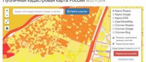
Why is the site not on the cadastral map?
In 2020, 70.3 million land plots are registered in the Unified State Register of Real Estate. And only 61% of them are displayed on the public cadastral map. The property has a cadastral number, a tax notice is sent annually, but it cannot be found on the site map. Let's look at the reasons why this happens.
What does the cadastral map show?
The map displays only land plots that are included in the Unified State Register of Real Estate with certain boundaries
. Registration of a plot in the Unified State Register is called cadastral registration. Determining the boundaries of a site, or land surveying, is one of the stages of such accounting. Until 2001, this procedure was not mandatory, so millions of plots were registered without coordinates (we even compiled a visual cadastral rating of regions according to border registration).
Using the example of cadastral quarter 10:14:0040109, it is clear that only one owner of plot :20 carried out land surveying. And its neighbors are not shown on the map:
It is easy to check the situation with the boundaries of a plot, knowing its cadastral number. We enter the number into the search line on the cadastral map, for example 10:14:0040109:20. If the boundaries are taken into account, the map will highlight the area with a green background and the card will indicate “ Landing: completed
»:
If the boundaries are not registered, for example, for the site 10:14:0040109:21, then the object card will have a red entry “ Landing: not carried out”
»:
Owners often write to us when they cannot find their plot on the map. The problem cannot be ignored; it is fraught with difficulties in the future. Solutions depend on the specific situation.
Land surveying was done according to outdated legislation
Since 1990, land legislation has changed several times. The legal norm on a site map appeared only in June 2001, when the Law “On Land Management” came into force. In 2009, the Government established new standards for coordinate measurements. Therefore, the boundaries of plots demarcated before 2001, as well as in the period 2001–2009, may not be included in the Unified State Register and on the public cadastral map.
In this case, you may even have an old cadastral passport, where the site plan is indicated, but the coordinates of the corners will be missing:
Therefore, Rosreestr does not know where exactly your site is located and cannot display it on the map.
How to fix.
Carry out land surveying in accordance with current legislation by contacting a cadastral engineer. Then submit the finished boundary plan to Rosreestr through the MFC, paying a state fee of 350 rubles. The site will appear after the boundaries are registered in the Unified State Register and the cadastral map is updated.
Surveying carried out recently
You have carried out land surveying and registered the land survey plan in Rosreestr, but the site is still not on the cadastral map.
How to fix.
Just wait for the next map update. The public cadastral map is not updated in real time. The update speed depends on the regional divisions of Rosreestr. Some Offices upload to the map once a week, others several times a year.
Until the map is updated, you can take an extract from the Unified State Register to be sure that the borders are correctly taken into account by Rosreestr. The extract must contain section 3.2 “Description of the location of the land plot.” There you will find the coordinates of the corners of the site, even if it is not yet on the map.
Please note that the points in the statement are indicated in the local coordinate system - this is not GPS. To relate them to the actual map, use our survey calculator.
No land survey has ever been carried out
Until 2001 and in 2006–2009, legislation allowed the registration of real estate objects for cadastral registration without first determining their boundaries. For such plots, in the column “Special notes” of the extract from the Unified State Register it is indicated - “The boundary of the land plot is not established in accordance with the requirements of land legislation.”
Please also pay attention to the “Record Status” column. It will indicate that the information has the status “Previously recorded »
. Those. information about the plot was entered into the Unified State Register of Real Estate automatically from the old real estate register.
How to fix.
It is necessary to carry out land surveying in accordance with current legislation by contacting a cadastral engineer. Then submit the finished boundary plan to Rosreestr through the MFC, paying a state fee of 350 rubles. The site will appear after the boundaries are registered in the Unified State Register and the cadastral map is updated.
Technical and registry errors in the Unified State Register of Real Estate
Errors sometimes occur during land surveying and state registration. They can be approved by both the cadastral engineer and the Rosreestr services. The result of such errors may be the absence of a site on the public map or its incorrect location.
How to fix.
Contact the MFC with the existing boundary plan to correct the error. Rosreestr will correct the error within 3-5 business days.
The main thing about areas without borders
If the boundaries of your site are not visible on the map, then most likely land surveying has not been carried out in accordance with current legislation. This does not deprive you of ownership of it. The law does not oblige the copyright holder to carry out land surveying. But selling such a plot will be more difficult. Rosreestr has the right to suspend registration of the transfer of rights and then the transaction will not take place.
It is important that unregistered boundaries reduce the market value of the property and provoke conflicts with neighbors. It is impossible to carry out legal construction on such a site. Therefore, we recommend conducting boundary surveys before the purchase and sale transaction, as well as when planning construction.
If your site is marked on the map, but the boundaries are incorrect, this is a different situation. It needs to be fixed urgently. We wrote about the reasons and methods in a separate article.
If there is no distinction
The lack of information is also the reason why there are no boundaries of the site on the cadastral map. If there is no information, the owner’s actions are as follows:
- Collection of information.
- Contacting a land management organization. All work is carried out after concluding a contract, which specifies the terms, work procedure, and method of payment.
To conduct land surveying, the representative must have a license. Carrying out any manipulations on your own is considered illegal. Upon completion of the procedure, the subject is given a survey document (in two copies). One copy is handed over to representatives of the cadastral chamber.
Why is the site not on the public cadastral map?
Why is there no plot on the cadastral map?
In addition to the fact that information about the allotment may not be entered simply due to a mistake by Rosreestr employees, the plot on the cadastral map may be missing for the following reasons:
- He was not registered in accordance with the procedure established by law.
- Land surveying was carried out until 2001.
- There are no clearly defined boundaries of the allotment.
In any case, the first thing you need to do is find out from Rosreestr why the site is not mapped. To do this, you can make a written request and wait for a response. The algorithm for further actions depends on the situation.
Lack of registration in accordance with the procedure established by law
Let's say you find out that the plot is not on the cadastral map due to the fact that it is not registered in the manner prescribed by law. To correct this situation, you need to:
- Carry out land surveying.
- Collect the necessary package of documents. Its composition depends on how the allotment was received (as a result of a transaction, inheritance, etc.).
- Submit the collected documents along with the survey file, receipt of payment of state duty and the applicant’s passport to Rosreestr.
After the documents have been reviewed, the owner of the plot will be issued a title deed. Then Rosreestr specialists mark the site on the cadastral map.
Land surveying before 2001
It may also happen that the plot was assigned a cadastral number and is owned by a citizen (which is confirmed by the relevant documents), but it is still not on the cadastral map. This may happen because land surveying was carried out before 2001 (before the Federal Law “On the State Land Cadastre” dated January 2, 2000 No. 28-FZ came into force).
At the same time, the Law “On Cadastral Activities” dated July 24, 2007 No. 221-FZ contains a provision that all plots that were registered in the prescribed manner before this act came into force are considered previously recorded. Information about such plots can be included in the cadastre after the owner contacts Rosreestr and submits the relevant documents. Also, a citizen may be required to conduct a new land survey to determine its boundaries.
Please note that the data on the public cadastral map is updated several times a year - accordingly, information about newly registered plots may not appear on it immediately.
No land boundaries
If a response is received from Rosreestr that the site is registered, but there is no information about its boundaries, then the citizen must conduct a land survey. For this you need:
- Collect title documents for the site.
- Contact the land management (survey) organization. When concluding a contract, it is recommended to discuss both the timing of the work and its cost, as well as the payment procedure (prepayment, payment upon acceptance, etc.).
It is impossible to carry out land surveying on your own, since for this you need to have the appropriate license.
Based on the results of the work, the customer is given a survey document in 2 copies. One is transferred to the cadastral chamber, the second remains with the owner of the site.
For reference
The absence of boundaries of a plot on the cadastral map is not an obstacle to making transactions with it for its alienation to third parties. However, during the process of drawing up the contract, you should immediately decide who will be engaged in land surveying (if, for example, the buyer does this, the seller may well reduce the cost of the site).
More useful information is in the “Earth” section.
Cadastral value of real estate according to the cadastral number of Rosreestr
If you are interested in the cadastral value of real estate for presentation to official authorities or third parties, it is better to order an extract using the cadastral number of Rosreestr. It is generated in the services section on the organization’s website; it can also be ordered through your personal account on the government services portal.
The Rosreestr cadastral number is like the DNA code of an apartment. It is completely unique, it encrypts the location of the property, and, knowing its meaning, you can find any information about the characteristics, features of the property, its owners and history. It is a numeric code of 4 groups, separated by colons.
We recommend reading: Find out the waiting list for housing in Irkutsk
What are the red lines on the cadastral plan?
Let's get back to the actual terms and meanings of the red lines. Thus, the draft red line has no legally significant force. Conventionally, this is a recommended boundary that allows owners of the right to clarify the boundaries, conduct construction and carry out the process of legitimizing the boundaries of the land plot. At this stage, it is possible to determine the exact boundaries of the allotment before the trial.
When turning to a public map of the Russian Federation or ordering information from the State Cadastre, many see atypical graphic images in the drawing, such as colored outlines. Let's figure out what these red lines are on the cadastral plan for documents and for the owner of property rights? Let us explain that the red lines themselves on the cadastral plan are lines that are intended for urban planning, along which the boundary of the site is determined where construction of a specific legal object or engineering structure can be carried out.
This is interesting: Labor veteran of the Tver region how to get