Land surveying is a set of works to fix the exact coordinates of the boundaries of a land plot and enter them into the real estate cadastre. Many people confuse land surveying with boundary removal services
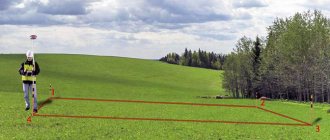
Setting out boundaries is marking on the ground. It looks like pegs driven into the ground. Pegs are signs marking the boundaries of a site. Such work takes place provided that the land plot is registered in the cadastral register.
Land surveying in Moscow and the Moscow region is possible only if you have a cadastral number for the plot and registered rights.
How do you know if you need land surveying?
First you need to find out the cadastral number of the property. There are several sources of this information:
- Request through the Rosreestr website;
- Cadastral passport;
- Cadastral Chamber;
- Certificate of registration of rights.
Knowing the cadastral number, it will not be difficult to obtain the necessary information. The website of the Public Cadastral Map stores information about all registered plots, their location and boundaries. The public cadastral map contains the exact navigation coordinates of objects.
By entering the number in the search bar, you will see whether there is registered data about your property. If they are, the map will show you the exact location of the site. If not, the information card will say: “Plot without location identification.” This means that it needs to be surveyed.
Why is land surveying needed?
In fact, this procedure allows the owner to legitimize the location and boundaries of the land plot. Therefore, in any situation where confirmation of ownership of a certain part of the land is required, it is necessary to carry out boundary work:
- Registration of transactions. Any notarial transactions in relation to the site cannot be carried out without establishing the boundaries of the object. Since the transaction involves a transfer of ownership, it is necessary to determine the part of the land that it covers. If there was no land survey at the time of registration of the transaction, it must be carried out to determine the boundaries of the object. Sometimes, when purchasing a plot, the future owner receives from the previous owner certain drawings and plans that are not included in the cadastre. Often, already in the process of building a house, it turns out that construction is taking place on someone else’s land. At the same time, the previous owner may not know about the actual boundaries if he did not carry out any work there.
- Restoring borders. It happens that documents about land surveys that were once carried out were lost. Or mistakes were made in the boundary plan. This usually becomes clear when an object that has been owned by one person for a long time gets a new owner. Drawing up a new boundary plan with updated data solves this problem.
- Home construction. The construction of a capital structure requires a building permit. You can obtain permission by determining the boundaries of the site where construction work is planned. It will not be possible to build and register an object without carrying out land surveying.
- Separation from collective ownership. In such cases, the user of the site who wishes to become its owner is obliged to draw up a boundary plan. Based on the information contained in the plan, the exact boundaries of the allotment will be established.
- Division and unification. When one plot is divided into several smaller ones, or vice versa, individual areas are combined into one whole, it is necessary to clarify and fix the parameters of the new land units. In addition, the preparation of any documents (cadastral passport, certificate of ownership) also requires this procedure. Each new object, allocated from the total area or obtained through a merger, must be registered in the cadastral register.
- Increase in area. The Land Code makes it possible to expand the boundaries of a site by adding neighboring lands if they do not belong to anyone. This procedure cannot be carried out independently. New data must be submitted to Rosreestr.
- Litigation. In most cases, disputes arise between the owners of adjacent plots and concern the determination of the boundaries of each of them. In such situations, the dispute can only be resolved by information stored in Rosreestr, that is, obtained as a result of land surveying. In this case, the boundary plan is an official document confirming your case and can be used in court.
Methods and methods of carrying out the procedure
The methods and methods of carrying out the procedure are considered complex complex work. They include two diverse categories of events:
- geodetic measurements and calculations;
- cartographic research.
Read also: How to apply for a pension and benefits at the MFC
Both types of procedures must be performed exclusively by certified specialists who are authorized to engage in this type of activity. Technical workers of this profile are cadastral engineers and surveyors. The former keep public documentary records of land, while the latter are given the right to make instrumental measurements in open areas, as well as perform calculations related to them.
The table shows some features of the above-mentioned works.
| Type of work | Features of the procedure |
| Cartographic | They do not take a long time, because they involve the collection of information available on paper or electronic media. To carry out this operation, a specialist from the land department will need an original and a copy of the landowner’s document (in the case of establishing the boundaries of an existing plot), so the applicant needs to take care of the availability of the latter in advance. |
| Geodetic | They are painstaking work and that is why, if necessary, they can be produced over a long period of time, and sometimes repeatedly or repeatedly. In the process of geodetic research, specialists establish the real boundaries of the plots, the condition and presence of delimiters (or the presence of boundary signs), and also establish the compliance of technical indicators with the documented ones. |
The result of geodetic work will be the issuance of a document, a kind of technical passport for the land, which will necessarily indicate:
- easements (laws and by-laws, their individual articles and clauses, provisions of local councils and other documentary acts that have legal force at the time of work);
- techniques used by specialists in the process of geodetic surveying;
- boundaries of the site after the survey procedure (geographical coordinates, direction relative to the cardinal points and length of the sides of the plot).
Also, in the boundary plan issued by the specialists who carried out the measurements, there must be a conclusion about whether discrepancies with the previous document were recorded or whether they are absent.
When conducting geodetic surveys, the presence or written consent of the owners of neighboring plots is required. A separate column in the document contains a written conclusion on the coordination of the boundaries of the site with the neighbors and the absence of claims on their part.
Neighbors should be notified of the date of such measurements no later than thirty calendar days before the work is carried out. Usually this action is assigned to specialists from the land use department, but if the applicant has the opportunity to do this independently, then the land surveying process will take much less time. But this is only in the case when the neighbors have no complaints and deign to voluntarily come to the land registration department.
At the end of these procedures, specialists from the land use department or village (city, district) councils vested with similar powers analyze and coordinate the available data. And only after this the applicant is issued legal documents that confirm the right to use a certain plot and indicate the exact location of the latter.
In what cases is land surveying not necessary?
- Inheritance of a plot with land surveying already carried out. If the future owner inherited a plot with defined and registered boundaries, land surveying is not necessary. However, there are often several heirs to the land. Here it is necessary to allocate ownership rights to each part of the plot. You can limit yourself to formalizing the procedure for using the object, but more often the heirs want to allocate their ownership rights.
- General development. In the case of complex construction on a large plot of land, a boundary plan for a separate territory will not be needed. But in the case of developing a separate site for its intended purpose, it is mandatory.
How is land surveying carried out?
- First of all, you need to collect the necessary documents. If the site is determined for the first time, you will need its location diagram on the cadastral plan of the territory, which will subsequently have to be approved by the local Administration or the City Property Department. If the customer is already the owner of the property, only an extract from Rosreestr/certificate is needed;
- Cartographic material is required on which the land plot is indicated. This document must be dated more than 15 years ago. These could be old sales contracts, certificates with an insert, BTI plans, for plots located within the boundaries of gardening non-profit partnerships - copies from the General Plan.
- An agreement for the provision of cadastral services is concluded between the customer and the geodetic company. At this stage, the cost of the work and the timing of its completion are agreed upon;
- After the documents have been collected, land surveying work begins. They include geodetic measurements and placing turning points on the ground. The work is carried out using a total station and GPS receiver;
- All information is transferred to the cadastral engineer, who correlates the available cadastral map data with the information received from surveyors;
- Next, the cadastral engineer draws up a boundary approval act, according to which the boundaries proposed by the owner of the plot do not raise objections from the neighbors. If there are any objections, they are accepted in writing and included in the survey file;
- Based on the data received, land documents are drawn up. The result of all land surveying work is a land survey plan, which is submitted to Rosreestr.
Procedure for establishing a private easement
In standard situations, the establishment of a private easement on a land plot occurs on the basis of a written agreement drawn up and signed by the interested party and the owner of the plot.
When drawing up and executing an agreement, it is important to ensure compliance with civil law standards that take into account the interests of both parties. The format of the agreement is regulated by clause 1 of Art. 161 of the Civil Code of the Russian Federation, with the mandatory inclusion of the following sections:
- Information about the parties to the agreement, addresses, bank details.
- The specific location of the object in question.
- Reasons for the need.
- The essence of the agreement being concluded.
- Mechanism for implementing limited use rights.
- Responsibility, rights, obligations.
By signing the agreement, the second party receives the right, subject to certain conditions, to use the territory in accordance with established purposes. As soon as the circumstances and grounds under which the need for the right arose disappear, the validity of the document also ceases. The owner of the plot has the right to set fees for the use of land at his own discretion. In fact, the payment is a consideration received for the provision of a temporary right to use property by the other party to the contract.
In the absence of mutual understanding between the parties, the interested party files a claim in court with a request to grant permission for access or another way of using the adjacent plot, taking into account the need to ensure their right to use their land.
Registration of rights
The registration procedure can be considered completed only after state registration of the agreement on the establishment of an easement. To do this, the parties contact the Rosreestr office with an application and the attached package of documents.
Download the Application for establishing an easement agreement for individuals. persons (20.6 KiB, 196 hits)
Application for establishing an easement agreement. Sample for legal entities (20.9 KiB, 206 hits)
Application for establishing easement of part of the site for individuals. persons (20.8 KiB, 190 hits)
Application for establishing easement of part of the site for a legal entity. persons (20.9 KiB, 180 hits)
The list of documents required to make a registration entry is presented:
- a cadastral plan, on which there is a stamped restriction mark;
- decision of a judicial authority, administrative act of a government agency, agreement;
- payment document confirming the paid state duty;
- passport of the interested person (applicant).
Depending on the category of owner, the amount of the fee will be:
- 1.5 thousand rubles – for ordinary citizens;
- 6.0 thousand rubles – for organizations.
A registered right is not established for a limited period of time. The duration of the right of use is determined by the period of compliance with the conditions and grounds specified in the administrative document.
Benefits of working with us
- We guarantee measurement accuracy up to 10 cm throughout the Moscow region. Our company has an agreement with a certified network of satellite stations;
- All dates are agreed upon in advance. The customer receives notifications from us about the progress of work at each stage in the form of SMS, call or email;
- The price of services is adequate to the quality and timing of the work performed. The cost of surveying is from 15 thousand rubles. per plot up to 15 acres.
Since our company is socially oriented, we offer discounts for certain categories of citizens. The discount on cadastral work for large families is 30%, for pensioners – 15%. If you order a volume of work simultaneously for several objects or for a large area object, the price is also adjusted downward.
Our specialists will carry out the entire procedure exactly within the agreed time frame. As a result, the customer receives a boundary plan in electronic form.
Since development in the Moscow region is very active, land surveying services remain one of the most in demand. Errors in such a procedure are fraught with many problems, so it is better to trust the work to proven specialists.
Cost of work
The cost of land surveying work not only varies across federal districts, but may also vary depending on various components. The price of the service depends entirely on many factors, the main ones being:
- accessibility of the area for taking measurements using standard methods and simple measuring instruments;
- use of instruments and software to establish plot boundaries;
- weather conditions and regional terrain features;
- the length of the sides of the site and the number of points whose coordinates need to be calculated;
- technological complexity of the work for the contractor;
- price per hour of work (hourly rate) of the land surveyor (set by the enterprise independently, since most organizations are self-supporting groups).
Also, the cost of work to document the boundaries of a plot of land includes the so-called “urgency”.
The State Certificate price for land is set by the self-government body on whose territory the land plot is located, and also includes mandatory duties and fees. On the territory of some federal districts there is a special procedure and limited rates of fees for work to establish rights to plots of land used:
- associations of citizens (gardening societies for growing fruit and berry crops) and unorganized individuals for growing vegetables and fruits;
- for private construction, landscaping and subsequent operation of houses and ancillary buildings;
- for running a household that does not involve commercial use of land (including leasing);
- garage cooperatives.
This category also includes plots allocated for separate buildings for storing personal vehicles.
An applicant who applies to government agencies to establish property rights to a newly allocated plot pays a fee, the amount of which is established by current legislation, a protocol of a community meeting or any other document of federal, regional or city significance. It should be noted that the amount of the state duty, the cost of cartographic or geodetic work, as well as other fees depends on many factors, including:
- economically significant indicators (profitability, profit, reimbursement of taxes and fees, business expenses of the contractor, be it the cost of renting premises, depreciation, etc.), included in the price list for the provision of various types of services to land users;
- the minimum hourly rate of workers involved in the work;
- subsistence minimum valid at the time of application;
- the cost of information services from organizations where you can order the land demarcation procedure.
You can reduce the cost of dividing land plots by applying for the provision of geodetic services to state-owned institutions. In such institutions, the fee is minimal and does not contain hidden fees. But in state geodetic services or departments there is usually a waiting list for work, so along with saving money, the applicant usually loses a lot of time, and some documents have to be ordered several times, because visas of notaries and government agencies have an “expiration date.”
It is not possible to carry out surveying of a land plot completely free of charge, although some categories of citizens (the list of benefits approved at the legislative level of the state, federal district or other territorial unit) may be exempt from paying all or part of the fee charged for the services of state enterprises involved in the process of issuing documentary evidence of the boundaries of the site.
In some cases, certain groups of applicants may not be able to pay out-of-pocket costs for special security forms or court-related procedures. Also, certain categories of citizens can find out for free or on preferential terms whether land surveying has been done previously, and also receive a certificate about this.
That is why it is not possible to give unambiguous answers to questions about how much it costs to survey a land plot, as well as what the cost of services is established in 2020. The only thing that can be said on this issue is that the cost of issuing documents for a previously unregistered site will be higher than the customer’s costs incurred in restoring or determining the boundaries of a previously documented site. And first of all, this is due to the procedure for assigning a land use class and checking documents related to obtaining official information that the site is not:
- located in protected, recreational or other environmental areas;
- belongs to no one else, and third parties have no right to dispose of it;
- is in collateral.
Read also: Consultation and legal services at the MFC
The price of the work will vary due to the cost of the resource itself. That is why the cost of registering and measuring a plot in the Moscow or Leningrad region will be greater than the costs incurred by the applicant for registering rights and demarcating a plot in the Vladimir or, for example, Chelyabinsk region or Petrozavodsk. Also, a frequent criterion for the price of land surveying is the distance of the latter from the city, regional center or capital.