Cadastral work is a set of activities aimed at collecting data on all types of buildings with their subsequent study and registration. They are needed to draw up technical documentation for houses and land plots. All information is taken to record buildings and enter them into the register. And on its basis, the owner draws up title documentation.
However, without the necessary data from Rosreestr, it is impossible to obtain the entire package of documents, and many restrictions are imposed on the site itself (regarding future transactions). For these purposes, cadastral engineers are invited to the sites, who carry out all the necessary surveys. We will tell you about them in detail in this article.
Cadastral works
Cadastral services are ordered when making adjustments to technical documents for any buildings and their territories. The procedure for their implementation is established by the Law of the Russian Federation Federal Law No. 122. This service is prescribed when carrying out any operations with a land plot and real estate on it:
- when registering property rights;
- during inheritance and division of property;
- purchase/sale, donation, privatization.
The area of the land plot is first checked for compliance with the urban planning plan. At the same time, the borders should not intersect with other territories and administrative units.
When demarcating, it is not allowed to subdivide the object in such a way that the object interferes with the use of adjacent lands. Research is carried out on plots where:
- individual or multi-apartment residential buildings, cottages, warehouses;
- engineering structures and communications;
- separate rooms for various purposes;
- objects planned for development;
- areas with unfinished construction.
Why is geodetic work required?
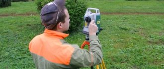
Geodetic surveys are required to obtain complete and accurate information about any specific area. That is, engineers need to clarify the coordinates of the turning points of the earth's boundaries, the characteristics of the relief, the presence or absence of underground or overground communications, etc. They explore the area using special high-precision equipment - it is mandatory certified every year, so each equipment must have a certificate of performed verification. With the help of such devices, topographic, geodetic and executive surveys are carried out, and then analysis of the measurements taken. Thus, it is possible to obtain accurate information about the condition of the property and where it is actually located. And now, after analyzing the data, you can create the appropriate documentation.
So, geodetic services include:
- topographical, geodetic and executive survey;
- installation of boundary signs (signs required to define boundaries);
- staking out design points (for example, foundation axes, etc.). These actions must be performed before the start of each construction.
Types of cadastral services
Entering an object into the cadastral register - registration is carried out for all types of real estate of any purpose and form of ownership. This information is taken for statistical reporting, analysis using graphs and charts, and various tables.
The boundaries (borders) of a site are clarified when its initial characteristics change. Parameters are calculated through photo and topographic surveys and measurements. The results are analyzed, systematized and entered into the technical passport and the state register.
Division of the territory - the progress of its implementation is influenced by the characteristics of the object. It is possible on plots with the same or different legal status. The procedure is prescribed in Article 7 of the Land Code of the Russian Federation.
The drawing up of the boundary plan is carried out according to the taken measurements after the approval of the boundary and other measures. It specifies all the dimensional parameters of the allotment. The service is necessary in situations where the area and configuration are clarified or adjusted.
Obtaining a cadastral passport is mandatory when conducting operations with real estate and land, construction, or in the event of controversial issues. It contains complete technical and legal information used to designate and register a structure.
An extract from the cadastral passport is issued upon request if you need to provide partial information about the land. It contains only the facts as requested by the customer. An extract is taken when an object is liquidated, there are adjustments or legal restrictions.
The procedure for performing cadastral work
Preparation
During the preparation period, general and legal information about the object, installed utilities, and adjacent territories is collected and analyzed. An estimate is drawn up, deadlines are calculated and the required activities are planned.
Field tests
They involve geodetic or satellite surveying of the territory and surroundings, measuring work, and land assessment. They also clarify and coordinate boundaries with other adjacent land users, and fix turning points on the ground.
Desk analysis
At the desk stage, the data obtained during field measurements are processed. The information is used to draw up drawings and mark turning points. All calculations are carried out in specialized software. During the analysis, additional data on real estate may be required, which are requested from the relevant authorities as necessary.
Drawing up a boundary plan
This document involves combining text and graphic information. The basis for its writing is the cadastral plan. All nuances are taken into account here, including the configuration and location of utility networks. A technical plan is needed if there are buildings on the land plot. If necessary, a cadastral extract and other documents upon request are prepared.
Certificate of work performed
The final stage is the approval of the act of work performed with the owners of adjacent plots, and the prepared papers are signed. The sequence of their approval is prescribed by law. The data can be taken for study by various services, including the tax office.
What must an engineer do?
The cadastral engineer does the following work:
- plans to demarcate
- carries out all calculations
- makes the final plan
- draws up land surveying documents,
- draws up a report sent to the register.
The engineer is obliged to compare land delimitation standards by making an agreement with a geodetic company, however, the services specified in this agreement are not subject to the requirement.
Land management works
Land management activities are understood as a set of actions performed by government agencies together with geodetic services to study land plots and changes on them. This information is used as the basis for surveying areas with the installation of signs, as well as planning the method of exploitation of the territories.
This service is ordered when measuring the boundaries of administrative units and allocating land for agriculture and construction, conservation of unusable areas. Research includes:
- collecting data on the current state of land;
- description of the exact location of the borders, actual compliance of the parameters with the entries in the Unified State Register of Real Estate - all papers are drawn up in accordance with regulations;
- geodetic research, cartographic work, which involves collecting information on the territory being inspected by taking measurements of land ownership, determining heights and coordinates, and monitoring changes on it;
- calculating the boundaries of the site with the installation and fixation of signs, entering parameters into the established land management documents;
- planning the rationality of further exploitation of the land is necessary to assign it a designated purpose in accordance with approved development projects for the district and the country as a whole;
- on-farm development of land plots in remote areas used for agriculture without changing the traditional way of life of local residents.
The purpose of land management work is to bring land operations into the required order, expedient use for the benefit of the development of the state, as well as the protection of land resources. When degraded areas are discovered, measures are developed to restore their properties.
How to deal with pests of garden plants?
Innovative houses and cottages. Modern construction technologies
How has the demand for cottage communities changed over the past 5 years?
What is the best material for foundation waterproofing?
Why should you buy a cottage and not an apartment? And how to choose the best option?
Distant dachas. Is it possible to buy them now? Interview
Do you want to live in your own medieval castle? Construction of houses in a castle style. All the pros and cons
Ideal townhouse project. What should it contain?
Alternative energy and heating systems for a private home
What to choose for your dacha: an ax or a wood splitter?
Stages of land management
Preparatory
At this stage, archival data on the nature of the area, drawings, title documents, and information on the previous placement of land survey signs are studied. During this period, an agreement is signed with the customer, a preliminary estimate is calculated, and the approximate time frame for completing land management is determined.
Field
At the field stage, all research is carried out directly at the site. The land surveyor draws up a technical project, prepares documentation for adding new marks, takes measurements on the ground, surveys, and sets new site boundaries.
When planning and preparing technical documents, the following points are taken into account:
- reasons for land management and signs on the ground;
- installed signs and their changes;
- archival data about the territory;
- the need to perform new calculations.
Cameral
At the desk stage, the measurement results are processed and calculations are made using formulas. The results obtained are recorded in technical documents, which are submitted for approval to government agencies.
Innovations are approved within 1 month. Papers are checked for compliance with the provisions of the law, and sometimes government experts are brought in for approval to obtain an opinion on a given object.
The information received is used to prepare the following documents:
- general plans for land management of a specific administrative unit;
- schemes for the protection of territories and their use;
- plans and drawings of land plots with buildings;
- cartographic materials showing zoning and zoning, land condition, application modes;
- projects for reclamation and restoration of degraded lands.
What is all this for?
Cadastral and land management work is carried out only by specialized licensed companies. In combination with engineering surveys, they make it possible to obtain all the necessary data for the construction, reconstruction and major repairs of buildings, the consolidation and breakdown of land plots, and the change of their intended purpose.
Professional engineers carry out all necessary procedures in strict accordance with current regulations and legal requirements. The completion time depends on the volume of research, complexity of implementation and tasks to be solved.
It should be remembered that registration documents for real estate and land are issued only after cadastral activities have been carried out. Transactions with land and buildings without the availability of appropriate, correctly executed materials, according to the legislation of the Russian Federation, are considered invalid.
Who should you trust to carry out the work?
Remember that cadastral manipulations, according to the provisions of the Cadastre Law, can only be carried out by cadastral engineers. If you need to carry out cadastral or geodetic work, contact the GeoStroy company (here is the link to the website https://gs37.ru/uslugi). Services to clients are provided by professionals in their field with extensive experience. It is also possible to work on the formation of plots of land for the development of cottages, allotments for the construction of roads, etc. All specialists of this company have certificates of cadastral engineers and advanced training certificates.
The cost of the service depends directly on the type of specific object, its size and number of objects. The price for executive survey in most cases is determined by agreement, according to the volume of upcoming work on the site. The cost of drawing up an inspection report or registering an object with the state. cadastral registration – fixed.