Carrying out alignment work
During grading work, the grid is applied to the site plan with a frequency corresponding to the size of the building. The axes of the coordinate system must be directed parallel to the main axes of the building. The corners of the building, the joints of the foundation parts and the driving of piles are selected as key points.
What do surveyors do during a geodetic survey?
Main responsibilities
According to legislative norms, the participation of surveyors in the future construction of an object is not limited to the direct implementation of geodetic surveys. They are required to do a whole range of actions that precede the shooting, and are also carried out after it:
- Studying a construction project . At this stage, specialists read design documents, get acquainted with the features of the future building, and develop a plan for the future geodesy of the facility. To put this briefly, surveyors conduct a preliminary examination of the object of their subsequent work.
- At the second stage, the geodetic survey , during which the landscape and other features of the land plot are examined, which can have a significant impact on the construction process and lead to changes in plans. Specialists should also check the land plot for the presence of abandoned or unknown communications, for example, heating or water pipes, and check whether there are any unused structures on the site. After the survey, the construction plans are adjusted, and a control final geodetic survey is carried out, with the goal of clarifying and verifying the results obtained, on the basis of which a plan of the land plot will be developed with all the necessary coordinates necessary for the successful completion of the construction of the facility.
What to choose - cadastral or geodetic survey?
Among the terms of land use there are such concepts as geodetic and cadastral survey. Geodetic survey (or survey) is a broader concept that relates more to methodology.
This is complex work, the results of which serve as the basis for other projects, including cadastral surveying. They are carried out by surveying engineers.
The goals of IGI (engineering geodetic surveys) are:
- studying the terrain and depicting it on a map;
- linking linear structures, geological developments, underground communications, hydrological sections to the situation on the ground.
A cadastral survey is needed to obtain complete information about a land plot and enter information about it into the state real estate cadastre:
- boundaries of the memory;
- categories of land;
- territorial zones;
- red lines;
- buildings and structures;
- lands and public areas, etc.
In this article we will look at how geodetic survey differs from cadastral survey.
Geodesy (geology) of the site before construction begins
Home » Geodesy (geology) of the site before the start of construction
Geodesy (geology) of the site before construction begins
The surface of the earth on which all construction projects are being built is a rather complex place physically and geologically.
Differences in: – relief; – soil composition; – mechanical and chemical properties; – the presence and quantity of groundwater and many other characteristics.
All these features of a particular location must be taken into account when building a house. The science of geodesy studies all of the listed properties of a terrain.
All characteristics of the terrain must be known and taken into account both during construction and at the design stage in order to calculate the most reliable and economically efficient house design. To clarify them, a geodesy of the site is carried out before construction begins. The purpose of engineering and geodetic research is to provide designers and builders with comprehensive information about the features of construction in a particular area.
Reasons for conducting geodesy of the site
Without geodetic and topographical surveys on the ground, not a single house project can be developed and agreed upon. Based on the data obtained as a result of research, technical conditions for construction are formulated. Moreover, not only the cost of construction, but also the durability of the building and the safety of living depend on the accuracy and reliability of this data. On their basis, the house is also vertically linked to the terrain, the zero mark and the foundation mark are determined.
Conducting topographic and geodetic surveys is a norm prescribed by current legislation. Research results are a prerequisite for laying communications.
Topographic and geodetic plans are an image on paper of a horizontal projection of the terrain on a scale of 1:500 without taking into account the sphericity of the Earth. This scale is the most common today and is the standard for coordinating and protecting a future project. On the general plan of the area or settlement, according to the research data, the axes of the designed building or structure are linked to the signs of the geotechnical map.
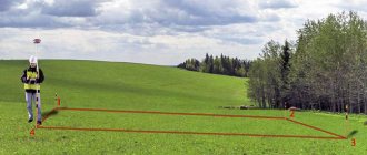
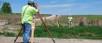
How is site geodesy done?
Geodetic reconnaissance, which will later result in plans and projects on paper, initially involves working on the ground. A team of surveying engineers equipped with special equipment goes to the construction site of the house. First of all, this is a drilling rig on the chassis of a special vehicle. Its task is to drill a certain number of wells sufficient to determine the composition and nature of the soil.
The location and number of wells are determined by the design engineers. As a rule, these are points in those places where the foundation of the future building will bear the greatest load. This is important, since in order to correctly select the type of foundation, it is necessary to know the characteristics of the soil on which they plan to build the structure.
The first stage of drilling is static sounding. A metal rod is pressed into the ground, and the frontal and lateral resistance of the soil is determined by how it behaves under load. Probing occurs until the rod begins to lose the rate of penetration required by building regulations. Parameters of frontal and lateral pressure are entered into the drilling log.
Subsequently, when drilling at the site, soil samples are taken, the depth of the aquifers and the nature of the groundwater are studied. Also, as part of the study of the territory, the following is carried out:
– collection of cartographic materials; – office work; – coordination of installed communications with operation services; – preparation of a technical report and submission to the design organization and urban planning authorities.
Separately, it should be said that all geodetic work is carried out in the warm season. And not during the spring snowmelt. Summer and early autumn are optimal. In winter, geodetic work is not carried out. In administrative terms, to conduct a geodetic survey of a site for building a house, you need the “go-ahead” of local governments and the architectural department in charge of the given territory. Survey work must be carried out by an organization that has the appropriate certificate and state license.
Of course, when ordering geodesy of a site for building a house, you need to be sufficiently aware of prices. Each organization has its own, and the list of positions produced within the framework of such work can take up more than one sheet. Some average market prices for geodetic work are shown in Table 1.
Table 1. Cost of geodesy of a site for building a house
| Works | Price, UAH |
| Laying out axes, setting out site boundaries, setting out benchmarks | 2000 |
| Realization of a land plot (price per point) | 300 |
| Project for changing the purpose of a land plot | 6500 |
| Topographic survey (price per working day) | 900 |
| Mapping out the boundaries of a land plot (price per point) | 250-350 |
| Topographic survey of areas up to 30 acres | 2000-2500 |
| Topographic survey of areas up to 12 acres | 1000-1500 |
| Geodetic study of the site for the foundation to a depth of 10 m to a perimeter of 8x8 m | 4000 |
| Geodetic study of the site for the foundation to a depth of 10 m to a perimeter of 10x10 m | 4500-5000 |
| Full geodetic support for the construction of a facility with an area of up to 1000 square meters. m. (price per month) | 20000 |
| Assignment of a cadastral number of a land plot | 1600 |
Result of site geodesy
When field work and laboratory studies are completed, a report is prepared based on them, which contains comprehensive information on the given territory. Based on the drilling data, so-called desk processing is carried out. Its result is a report on the engineering and geological conditions at the site of the proposed construction. This report should include:
– description of engineering and geological conditions; – technical conclusions; – text applications; – graphs, summary list of indicators of physical properties of soils; – copy of the license; – description of completed wells; – analysis of water extract from the soil for its aggressiveness towards concrete; – graphic applications of engineering-geological section; – well location plan; – hydrogeological maps; – bedrock roof map; – geophysical profiles, etc.
Based on the results of these studies, the architect or engineer develops the foundation design. This will eliminate unnecessary costs during construction and is a significant guarantee that the house will not settle.
What if the site is not surveyed before construction?
The question may seem somewhat naive. But, as practice shows, the desire to save money is expressed not only in the use of Chinese materials and hiring covens. There are many attempts to save on geodesy, for example, to make a foundation similar to that of a neighbor or to use topographic maps made in this area years earlier.
However, geodetic research is precisely part of the preparatory work for the construction of a house, the savings on which most often “backfire.” At best, this results in the fact that three times more money is spent on repairing walls and strengthening the foundation than was saved on survey work. The foundation of the house must be strong and adapted specifically to the specific type of soil.
Refusal to geodesy the site leads primarily to incorrect calculation of the foundation. That is, the foundation will be either too expensive or not reliable enough. The consequences of such mistakes usually do not take long to arrive. This may result in subsidence of the foundation, the first signs of which may be jammed doors, cracking glass in windows, or peeling plaster.
The lack of data on the characteristics of the site can lead to the appearance of water in the basements due to insufficient waterproofing or close groundwater levels. Errors may be made when arranging drainage systems on the site or incorrect installation of storm drains, not to mention the location of the septic tank.
Problems may also arise during utility lines. For example, if water pipes end up at the depth of groundwater, then in winter these pipes may collapse due to freezing. The lack of geodetic data may simply delay the start of construction work. Finally, in a bad case, everything will affect the construction and landscape design in general (you can read about the features of landscape design of a country house in another article).
Similar articles
- Groundwater - combating groundwater
Choosing a plot of land for construction is a rather complex issue, due to the large number of factors that can influence the decision. This is distance from highways, communications, natural settings... - Design of prefabricated buildings is the basis for construction success
Prefabricated buildings and structures made from modern materials are a reasonable solution for industrial construction. An increasing number of customers are choosing prefabricated building technologies... - Landscape design of a plot
Every person who owns a country plot strives to make it as comfortable and cozy as possible. Before proceeding with the actual registration of your...
Complete list of geodetic works on the land plot
Construction of facilities on a land plot should begin with geodetic work. You don't want to build a house and then realize it's collapsing because the foundation isn't stable on loose soil.
To prevent this from happening, you should contact specialists.
When should you contact a specialist?
You should contact surveyors before purchasing land. You can consult and ask questions. For example, is it worth purchasing a plot in a certain area, is such an area suitable for construction.
And surveyors will conduct research after your purchase. After receiving the documents, you will be able to register the site and plan construction.
Basic Concepts
There are few important concepts: it is necessary to clarify what land surveying is, as well as the geodetic work carried out within its framework. Other, more specialized terms used in the course of work are not necessary for site owners to know.
Surveying
This is the name given to a set of measures during which the boundaries of a site are precisely established and separated from neighboring ones. This work is required in several cases:
- if you need to form a new section;
- the existing one has inaccurate boundaries;
- a plot is divided, another one is separated from it, or, conversely, several properties are combined.
During the work, boundary markers are installed, the exact area of the land plot is calculated, and its parameters are determined more accurately. The territory is secured using boundary signs, and a detailed plan is drawn up. Land surveying is carried out by specialists; for this purpose, technical means are used, which allows its results to be considered official after they are approved.
Land surveying is necessary to make transactions. This way it will be precisely determined which plot of land is being sold, and all possible contradictions with neighbors will be eliminated. The fact is that previously, according to the law, it was not necessary to accurately establish boundaries, and only cartographic surveying, which was less accurate, was sufficient.
Registration of rights was carried out according to the resulting inaccurate plans. And all rights and transactions formalized then remain valid, but for those that are carried out now, there are different requirements. Now, in order to register the object of the transaction in the register, without which approval of the transaction is impossible, it is necessary to carry out a full land survey.
However, it is not always mandatory: for some areas, Federal Law No. 93 (known as the “dacha amnesty law”) establishes a simplified registration procedure. These are, first of all, those plots for which citizens received rights before the Land Code came into force (end of October 2001). But even in these cases, it is sometimes worth doing a land survey, at least in order to resolve disputes with neighbors, since due to the inaccuracy of old documents, the plots on them can literally overlap each other.
Geodesy
This is the name of the science that deals with the Earth - determining its area and other important characteristics, such as the gravitational field, rotation parameters and the like. Geodesy is based on the achievements of mathematics and physics, and technologically, thanks to the study of the planet as a whole and its various sections, it ensures the creation of an accurate coordinate basis.
In relation to land surveying, only a small part of the achievements of geodesy is used; with its help, an accurate measurement of the boundaries and area of the site is ensured.
And after the geodetic work has been carried out, the results must be documented for subsequent recording in the register. This is done by drawing up a survey act. After it is signed by the specialists who carried out the survey, the owner of the site and his neighbors, the procedure will be completed.
Why do you need a topographic survey of a site?
Before making a site plan, a topographic survey is carried out. This is an extremely important procedure. Moreover, it is required not only formally, during land cadastral registration, and not only for large construction companies. It is vitally necessary, for example, for the owner of any, even the smallest plot of land. After all, only accurate marking of the boundaries of your property and a plan for underground communications will ensure that you avoid conflict situations with neighbors or various public utilities in the future.
Topographic survey is carried out in the following cases:
- connection to the electrical network, gas pipeline, water supply and heating network, telephone cable, heating network, sewerage;
- when redeveloping the above communications;
- upon obtaining permission to build a house;
- purchasing a plot of land for ownership or lease;
And when performing activities such as:
- Design work for the reconstruction and construction of buildings;
- Linking the construction site to the area;
- Calculation of the volume of excavation work (for example, when digging pits);
- Landscape design;
Let's consider specific situations when topographic surveys are indispensable.
Law and land surveying
The Federal Law “On State Registration of Real Estate” N 218-FZ, adopted on July 13, 2013, has undergone changes.
The latest important amendments in the field of territorial surveying were introduced into the Federal Law “On State Registration of Real Estate” dated July 13, 2015 N 218-FZ, July 2020. According to the actual amendments, the provision of paragraph 1 of Art. 19 states that citizens have the right not to survey land plots - but only until the beginning of 2020. After this date, land surveying will be a mandatory procedure, without which the purchase and sale or inheritance of undemarcated land will be impossible.
Land surveying is part of cadastral work. The boundary plan is fixed by the cadastral engineer after territorial measurements have been carried out.
Land surveying is an indispensable process; the Land Code does not provide for other ways to accurately determine the area of plots belonging to a particular owner.
Land surveying is a mandatory procedure for the following types of land:
- Transferred for permanent use from state reserves;
- Falling under distribution due to various circumstances;
- Requiring division, consolidation or allocation of a share.
According to the current law, from January 1, 2018, purchase and sale, registration of deed of gift or inheritance in relation to land plots without registration of boundary measurements is impossible.
Therefore, the relevant provisions of the Land Code should not be ignored.
According to the new rules, the territory cannot be sold, donated, or inherited if there is no boundary plan for the site.
Is it necessary to do a geodesy of the site?
The current legislation of Russia has norms and instructions governing the implementation of geodetic work. Having studied them, the question of whether it is necessary to do geodesy of the site disappears on its own. According to the current laws of the country, any construction is carried out after the approval of the project by the architectural department. The package of project documents must necessarily include the results of geodesy carried out on the specified land plot. So, if construction is planned on a plot of land, geodesy must be carried out first.
It is also very important to create a project to have information about the location of nearby utility networks, the presence of a slope of the site, and the position of the property relative to the cardinal directions. Such information greatly simplifies the process of creating a project. With its help it is very easy to determine the optimal location of the future building. Carrying out geodetic work also helps to reduce the costs required for construction.
Who conducts geodesy
If you need to carry out geodesy of a site in Moscow, you must contact a company specializing in such services. High-level specialists with many years of experience will conduct research and provide all the necessary information, plans, maps, technical projects legally. Professionally carried out geodetic work on the site contributes to the trouble-free connection of the structure to technical networks, the creation of unrivaled landscape design, construction strictly according to the established project, and as a result, a reduction in the cost of construction work. Specialists will quickly and efficiently carry out all research and provide a complete package of documents.
Geodesy is a very important event, because future construction, its reliability and durability depend on the quality of its implementation. It also influences the development of the territory, as it provides the best options for the construction of buildings for any purpose. With the help of geodetic research, you can determine the most advantageous option for creating a landscape.
Determining boundaries by coordinates
The coordinates of the boundaries are determined based on the data on the establishment of boundaries on the basis of a title document. The land surveying procedure involves, while maintaining the basic shape of the site, adjusting and clarifying the actual position of the boundaries on the ground in comparison with the data entered in the register.
That is, before drawing boundary lines along the coordinates of turning points, a preliminary stage of cadastral work is needed. Therefore, the customer submits a title document for the land plot to the geodetic company carrying out the work.
Based on this document, the contractor orders a cadastral extract with the information entered into the register. On the ground, the data specified in the cadastral information is verified with the actual use of the site.
In some cases, the information does not match, and adjustments have to be made, since the established procedure for using the plots is also taken into account. In this regard, the cadastral engineer can set new turning points, along which plots are demarcated and amendments are made to the cadastre records.
It is also possible to adjust boundary boundaries that have moved to the side as a result of the owners’ initiative. Thus, when surveying the coordinates:
- are determined;
- to be specified;
- change;
- are being restored.
Accordingly, boundary work makes it possible to carry out various additional procedures with the site in addition to defining boundaries.
So, by changing the existing boundaries, it is possible to add plots of land to an existing plot and register up to 10% of the land in relation to the total area of the land plot. And most importantly, by determining the presence of boundaries by coordinates, you can eliminate boundary disputes with neighbors.
Goals of geodesy
The main goals pursued when performing geodetic work for design and construction are:
- obtaining reliable information necessary to carry out construction work;
- establishing the boundaries of the future building on the land plot in accordance with the developed project;
- ensuring during construction the geometric shapes of structures in accordance with the approved project;
- establishing deviations of the geometric shapes of buildings from design documentation;
- study of deformation processes on the surface of a structure during construction work under the influence of natural phenomena or human actions.
Only with complete information can you understand why geodesy is needed
, how important it is to carry it out before the design begins. Different types of structures require different types of work. If necessary, ground, underground, aerial and underwater geodesy can be performed. Each type of work is aimed at establishing the required tasks and examining surfaces.
Why is geodetic surveying needed, and what are the parameters for it?
Geodesy of a land plot must be carried out every time it comes to:
- Reconstruction of the building.
- Construction of additional structures.
- Repair of structures or buildings.
- Construction.
During geodetic or topographic surveys, specialists solve problems such as determining the nature of the soil of the area , assessing the landscape and calculating the exact coordinates of the future construction site. As a result, a construction or road construction organization receives a geodetic plan made on a certain scale, which will become an important basis for subsequent actions.