Much has already been revealed in the title itself, and yet we will now discuss what “clarification of the boundaries of a land plot” is, “why” and “for what purpose it is being carried out”. The first thing to start with: establishing a boundary on the ground is part and one of the goals of mandatory land surveying! It is carried out after the object is registered in the cadastral register. In fact, you can clarify the border by relying on an extract from the Unified State Register of Real Estate (USRN), a cadastral plan of the territory or a cadastral passport and the catalog of coordinates of turning points contained therein. In what cases may it be necessary to remove points? Absolutely different: construction of a fence or buildings, coordination or resolution of territorial disputes with neighbors, familiarization with boundaries, purchase and sale of an object, etc.
Bringing out the boundaries of a land plot - what is it?
The concept of such removal is not legally enshrined. That is why sometimes the name of the procedure appears in modified versions in various documents. But this does not mean the absence of legislative regulation. Moreover, compliance with legal norms in this case is strictly necessary.
The general regulation procedure is described in the following legislative acts:
1. Land Code (Land Code of the Russian Federation).
2. Federal Law “On Cadastral Activities”.
Carrying out absolutely any geodetic and cadastral work must be carried out in strict compliance with state standards. This also applies to the procedure for drawing out the boundaries of a land plot. Each stage must be carried out in accordance with approved standards.
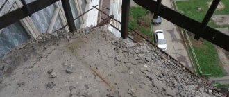
Determining the boundaries of the site and securing them with boundary signs
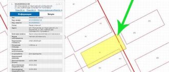
The land plot must be registered in the cadastral register with a completed list of reference coordinates (boundary plan). To compile it, a team of surveyors conducts a so-called cadastral (contour) survey of the site. When shooting an area, you need to “reference” to some reference points (bases), i.e. select a local coordinate system and determine all characteristic (usually corner, rotation) points of the site relative to the selected bases. This is done using a total station and GPS receiver. To mark the boundaries of a land plot on the ground, boundary markers are fixed at the turning points of the boundaries, the position of which is determined relative to the nearest points of the original geodetic basis. Then the received data is translated into one of the coordinate systems accepted in geodesy (SK-63, MSK-50, MGGS, etc.) and transferred to the cadastral department. The cadastral engineer draws up a plan of the boundaries of the land plot based on them.
Landmark
In case of loss of boundary markers established during land management work, the boundaries of land plots are removed from the area or the boundaries are restored. Sometimes situations arise in which it is impossible to determine the boundaries of a land plot without the use of modern geodetic instruments and experienced specialists. For example, you purchased a plot of land, the boundaries of which are not established on the ground, but there are only extracts from the cadastral chamber with known coordinates. In this case, our specialists will remove and secure the border of your site on the ground.
Purpose of the procedure and its essence
In practice, setting out the boundaries of a land plot is a procedure that consists of installing boundary signs on the territory of a specific land plot to indicate the boundaries. It refers to a type of geodetic work.
In this case, everything must happen in accordance with the documentary data available in the State Property Register - State Real Estate Cadastre. Currently, this body is called the EGRN (Unified State Register of Real Estate). In the case where such information is not available, that is, specific boundaries of the site have not been established, a preliminary land surveying procedure is necessary.
Calculation of cost of services
Determining the exact coordinates of the boundaries of land territories is a pressing issue for many private owners who doubt the definition of boundaries and are planning to sell or buy land. Land surveying is also necessary to carry out the process of privatization, donation, inheritance or division of territory. The land surveying procedure involves obtaining a cadastral passport for a land plot, including it in the unified state cadastre and assigning a unique number. In addition to the preparation of documents defining the turning points of the boundaries, boundary signs are installed on the land plot. Immediately after the completion of a set of geodetic works, temporary signs are installed to consolidate the results obtained in kind. Simple wooden stakes are often used as signs for short-term use. As for permanent boundary signs, several varieties can be used here. The first of these is a galvanized or metal pipe, the diameter of which can vary from 30 to 70 mm. The height of the pipe should be at least 105 cm, and in some cases, in the presence of unstable soils such as sand or clay, it should slightly exceed this value. A design feature of this type of boundary sign is the presence of a flattened lower base, as well as a retractable anchor, implemented in the form of a curved steel wire. There should be two holes above the base through which the anchor is pushed into the ground. A metal plate is mounted at the top of the pipe, which should have a cross-shaped notch. Also, there must be a metal plate welded to the pipe, which is used for applying the inscription. The second option for marking boundaries is to install boundary signs
in the form of wooden posts. The diameter of such a sign must be at least 150 mm, and the height must be at least 115 cm. Structurally, such a sign has a number of distinctive features. Its upper part has a cone shape, and a cross is made in the lower part.
What you need to install
As a result of drawing out the boundaries of the land plot, the necessary data is clarified, namely:
1. The exact value of the area of the plot.
2. Its shape.
3. Clear and defined boundaries.
4. Data on reliable location relative to the general land mass.
The totality of all this information is extremely important, since they serve for a holistic vision of the site, taking into account all its most important features and characteristics. In addition, if there are precise boundaries, both documented and factual, it is much easier to carry out a variety of transactions related to land.
For example, in order to sell a plot or register inheritance rights to it, the owner must have an idea of the exact limits of his own property.
Setting and Reinforcing Boundaries
The establishment and consolidation of boundaries on the ground is carried out when individuals and legal entities receive new land plots, when buying and selling, bartering, donating all or part of a land plot, as well as at the request of individuals and legal entities, if the documents certifying their rights to the land plot, were issued without establishing and securing boundaries on the ground.
The geodetic basis for land surveying are: − points of the State Geodetic Network (GGS); − points of the reference boundary network (MBN); − supporting boundary signs (OMS) (depending on the purpose and type, a concrete pylon is used; a concrete monolith in the form of a truncated tetrahedral pyramid; an iron pipe with a metal plate welded to it in the upper part for an inscription; a wooden pole; a freshly cut tree stump with a cutout for an inscription ; brand, pin, bolt, secured with cement mortar).
Geodesic condensation network
− a geodetic network created for the development of a higher-order geodetic network, intended for coordinate support of the state real estate cadastre, state monitoring of land and land management.
Support boundary network
− a special-purpose geodetic network designed for coordinate support of the state real estate cadastre, state monitoring of land and land management.
The location and density of OMS points (reference boundary markers - OMZ) should ensure the quick and reliable restoration of all boundary markers on the ground
. Whenever possible, compulsory medical insurance points are located on state or municipally owned lands, taking into account their accessibility. Compulsory medical insurance points may not coincide with boundary signs of the boundaries of the land plot. The reference boundary network must be linked to at least two points of the state geodetic network.
In what cases is it necessary to map out the boundaries of a land plot?
The list of such situations is as follows:
1. Loss of previously installed boundary signs.
2. Alternatively, the owner’s suspicions about an illegal change in the location of these signs (if you believe that someone moved them). It should be noted that the presence of boundary signs is not always mandatory, but securing them serves to the advantage of the owner and is an additional guarantee for him. Thanks to a clearly defined territory, he will avoid possible disputes and will be able to prove his own innocence if they arise.
3. The owner’s intention to erect a building or any structure on the site, including a fence. At the same time, he must have confidence that the structure exactly falls on the territory lying within his possessions. Otherwise, claims from neighbors are possible. If they are legal, the building will have to be demolished.
4. Change of owner of the land (for example, in the case of purchase, lease or sublease). In this case, it is necessary to verify the data available in the documents with the actual ones. Most often this refers to the configuration of the specific boundaries of the site and the declared area of its territory.
5. Carrying out land surveying procedures for their properties by owners of adjacent plots. At the same time, thanks to the delineation of the boundaries of the land plot, the owner will be able to protect his own territory from unauthorized seizure. Before signing the agreement, he will get rid of doubts about the accuracy of the results of the neighbor's survey in relation to the boundaries of his site.
6. Change of site status. For example, it will have to be divided into separate objects or, on the contrary, combined into one large plot. In this case, it is necessary to carry out the re-landmarking procedure with the installation of new signs.
In all of the above situations, the mentioned procedure is beneficial and necessary, first of all, for the owner of the site. It gives him the opportunity to use his own property in the most complete and legal manner.
Similar to any procedure, the removal of boundaries is carried out in accordance with a certain algorithm.
Preparation of documents
Having chosen a contractor and discussed all the conditions with him, the customer is obliged to collect a package of certain papers. You should have on hand: an extract from the Unified State Register of Real Estate, documents that can confirm the right to the plot (this could be a lease agreement, a certificate of ownership, an act for the allocation of land, etc.). The cadastral extract must be current. Without a detailed familiarization with it, the specialist will not begin work.
The official consolidation of the transaction after all the documentary aspects have been worked out occurs through the conclusion of an agreement. The drawn up agreement must contain all significant conditions regarding the cost of work and completion time, liability in case of violation of the accepted conditions. The contract must specifically list all types of work with an exact indication of the number of boundary markers that need to be installed.
It is necessary to indicate the expected results of the procedure and the composition of the documents issued. Then the customer makes an advance payment, which is usually half the final cost, and on the appointed day awaits a specialist’s visit to his site.
Lawsuit to restore borders
Any interested person can file a claim for restoration of borders, as well as a request to change borders or pay appropriate compensation for damage. Most often, territorial disagreements between neighbors arise due to the following reasons:
- incorrect definition of the boundaries of one or more territories;
- controversial establishment of boundaries after the division of one site into several new ones (within the contours of the old one);
- unauthorized transfer of boundary signs;
- the impossibility of accurately determining boundaries in areas with uneven relief.
In any case, the reflection of the true contours in the cadastral passport, in topographic survey materials, as well as the restoration of boundaries carried out is significant evidence. Therefore, along with the Removal Certificate, the following should also be attached to the statement of claim:
- certificate of land ownership (or lease agreement);
- cadastral passport;
- land surveying;
- other documents confirming the fact of certain boundaries;
- a receipt confirming payment of the state duty (its amount depends on the price of the claim).
The statement of claim itself is drawn up in any form, and the document must reflect several points:
- In the upper right corner the full name of the judicial authority, full name, contact information and addresses of all parties are indicated: plaintiff and defendant. A third party is also indicated here, which is almost always represented by the Federal Cadastre and Cartography Service.
- In the descriptive part of the claim, you should accurately and briefly describe the entire situation, if necessary, referring to legal norms (this is a desirable, but not mandatory condition).
- In the petition part, it is necessary to clearly formulate your demands, namely “to restore the boundaries of the land plot in accordance with_______.” If necessary, demands for compensation for material and/or moral damage are also formulated here. For example, neighbors illegally use your land, polluting it with construction waste, sewage, etc. In this case, it is important to provide relevant evidence:
- witness's testimonies;
- video recordings;
- results of examinations (for example, analysis of the chemical composition of the soil).
- At the end the applications are indicated - i.e. documents that are attached to the statement of claim. The full name, quantity, as well as types (copy or original) are written down.
A sample is shown below.
Sample statement of claim for restoration of borders (word)
Video commentary on the peculiarities of land disputes:
Transition to information processing
In some cases (if the area is large or has a complex shape), processing the received data takes several days. At the final stage, a so-called act of drawing out boundaries in nature is drawn up. It refers to desk work. When carrying out it, the cadastral engineer documents the work performed by recording specific information in the act of removing boundaries, namely:
— grounds for drawing the boundary (using data from the register extract);
- area of the site with its location;
— schemes for drawing out the boundaries of the land plot;
— information about the owner of the territory.
Stages of work and documents
Installation of land survey signs on the ground is part of cadastral services. Before concluding a contract, the land manager gets acquainted with the title documents for the allotment and orders extracts from the archives of Roskadastre. A surveyor goes to the site to provide the following types of work:
- field - determining coordinate values and fixing permanent or temporary signs on the ground at the locations of turning points;
- cameral - writing acts on the removal of boundaries to the area and acceptance and transfer of work, providing a photo report on the services provided.
Establishing the boundaries of the land plot according to the cadastral plan is possible if boundary work has previously been carried out with the transfer of data on the coordinates of characteristic points to Roskadastre. In this case, boundary markers are made in kind on the basis of information from the State Property Committee.
The documents on the basis of which the restoration of boundary markers occurs are acts of approval and on the removal of boundaries from the boundary file, the cadastral passport of the allotment. If there is a dispute with neighbors, re-installation of signs at characteristic points on the site occurs after court rulings are issued.
How the procedure is directly implemented
This event (taking out into nature the points of the boundaries of the land plot) occurs in the presence of special means called boundary signs. This is the name given to certain objects of artificial or natural origin, the installation of which, according to regulatory requirements, is carried out at each of the turning points of the site.
In practice, there are two types of such signs used - temporary and permanent. The first option is the cheapest and is used in the vast majority of cases. The main thing here is the minimum cost if signs are required. Their installation is most often carried out for the period during which cadastral work is carried out. Although in the future they can remain on the territory at the request of the owner.
The option with permanent signs is considered more expensive. According to current requirements, it refers to land management objects (as opposed to plots), but the owner can install them on a voluntary basis. In this case, these conditions are included in the contract with the contractor.
How are signs restored?
All fixed wooden stakes, metal pipes and poles along the contour of the owner’s territory are taken under protection. Their demolition and destruction is considered an administrative violation. Permanent signs have a service life of 5 years or more. However, over time, they also become unusable and are lost after demarcation of plots or construction work on the site.
The main reasons for ordering cadastral work to restore previously existing boundary markers.
- Sale of land: the future owner requires that the boundaries of the site be secured not only in documents, but also in fact.
- Lack of identifying elements in the form of fences or land survey signs that were damaged or lost.
- Carrying out construction, allocating a land share in kind, dividing home ownership and other special cases.
- The presence of disputes with the owners of adjacent plots for a peaceful resolution of the issue or before going to court.
Service-Geo specialists have experience in carrying out work of various sizes to establish site boundaries. The company's engineers consider special cases based on the provisions of the Land Code. Thus, the boundaries of the allotment, which were actually established, have not been disputed for 15 years or more, but are not documented, are considered legal and must be fixed on the ground.
Restoration of borders by court decision
Service-Geo engineers take part in conducting land management examinations appointed during the trial. Owners of plots contact the company at the stage of filing a statement of claim and collecting written evidence. During field work and research, surveyors draw conclusions about the accuracy of the results of land surveying carried out 10 years ago or more. If there are gross errors in the calculations, the expert draws up a conclusion recognizing the establishment of land ownership boundaries as invalid. The court may order a new survey, on the basis of which it can make an appropriate decision. As a result of cadastral work and the conclusion of the invited land surveyor, the judicial authorities make decisions on the restoration of plot boundaries and the demolition of illegally erected buildings, hedges and fences.
What do boundary signs look like?
Three types of objects are used as physical media - in the form of a metal or galvanized pipe, a wooden peg or pole, a metal stamp with a cross-shaped notch and an inscription. This option can be fixed at the base of various structures (curb, asphalt) using cement mortar.
Signs of the first and second types must simply be dug into the ground to a depth of at least 80 cm. One or another sign should be chosen according to the type of soil and climate inherent in a given region.
Signs may contain signs containing information about its number and the date of installation.
How much does the service cost?
As already mentioned, it is best to contact specialists from a geodetic company for such a service. Even if you want to carry out this procedure yourself, you will not find instructions on how to map out the boundaries of a land plot “with your own hands” anywhere. The owner simply does not have the right to do this.
This is also due to the high complexity of this work. In order to correctly perform all the required operations, the performer must have certain knowledge.
The cost of such services, as in the case of other geodetic work, is usually quite high. The exact price can be calculated only if you have specific data (number of turning points, area of the site, degree of urgency of the work). The final amount also depends on the prices accepted by a particular company or specialist, the location of the site, the completeness of the package of documents collected by the customer, the subject of the Russian Federation and other factors.
Most often, the estimated cost is given in relation to one established boundary mark and may vary among different organizations. The approximate price range can vary from 500 rubles to several thousand per sign.
If all the necessary documents of the owner are available, this procedure will not be particularly difficult. Otherwise, the owner will have to spend time filling out the missing documents or ordering a preliminary land surveying procedure.