Standards for setbacks from the boundaries of a land plot
Basic requirements for setbacks from the boundaries of the site, in order not to spoil relations with neighbors in the future and not have protracted legal proceedings, and also not to be under the threat of demolition by a court decision or the need to move an already built object - a house, a bathhouse, a barn, a garage .
1. You need to decide on all the buildings, plantings, flower beds, and ponds that will be located on the site in the future in order to correctly zoning the site.
2. When building a house, you need to pay attention to the construction site and the building spot in relation to the poles, and also take into account all future buildings and plots of neighbors in relation to the shadow of the house falling on them.
Distances to the street and passage: · From the house and outbuildings to the red line of the street - at least 5 meters. ·
We divide a country plot of land into zones
But it is necessary not only to designate the external boundaries of your suburban area. Internal markings also need to be done. It is called zoning , since the territory is conventionally divided into the following main zones:
- Living sector;
- Rest zone;
- Gardening area;
- Service and economic zone.
Marking and zoning of land.
About 10-15% of the area of a suburban area is allocated for buildings - a cottage, a summer kitchen, utility rooms, a gazebo, a garage, a swimming pool and others.
Approximately 15% of the area is occupied by internal communications (garden paths, parking, access roads) and landscaping, consisting of flower beds, flower beds, rockeries, hedges).
About 70-75% of the plot area is allocated for setting up a garden (the proportions may not be the same).
The zoning of a site is carried out arbitrarily by its owner: he can exclude some optional zones (for example, residential, entry zone, recreation area), and miss some (parking, playground, lawn).
A cottage or country house is the main object on the site, so the division of the territory into zones begins with it. The location of outbuildings should be near a residential building; at the same time, the buildings should be hidden from view, for which decorative thickets can be used.
The location of beds and flower beds should be in lighted areas, and plants that prefer shade should be planted near the house or in the garden. Some fruit bushes, for example, currants, raspberries, gooseberries, tolerate partial shade well, so they can be planted along the fence or near the walls of buildings that cast shadow.
The place for the recreation area is chosen by the owner of the dacha, who decides what he likes best: place the area near the pool, make it in the form of a cozy semi-open gazebo or an expanded children's playground.
When dividing the territory of a suburban area into zones, be sure to follow the principles of rationalism and practicality.
What are the minimum setbacks from the site boundary during construction?
In the case of individual construction, we are most often talking about zones of individual residential development (plots are allocated for individual housing construction or private plots and are located within the boundaries of a populated area).
In such areas, it is necessary to retreat at least 1 m from the border of the site (your own site, that is, owned by you) during the construction of a one-story residential building, 1.5 m.
– when constructing a two-story building, 2 m. – when constructing a three-story residential building, provided that the distance to the residential building located on the neighboring plot is at least 5 m. And in any case, it must be remembered that from the future residential building to the border of the neighboring plot, the distance is sanitary conditions must be at least 3 m.
Now let's take a closer look at the requirements for non-residential buildings. Basic rule: In areas with residential one- or two-apartment buildings, the distance from the windows of living rooms to the walls of a neighboring house and outbuildings (barn, garage, bathhouse) located on adjacent land plots must be at least 6 m.
We recommend reading: Free prevention of plastic windows - scam or not reviews
Coordinates of turning points
The coordinates of turning points, recorded by boundary signs on the ground, are determined separately in a special table in the boundary plan. This data is not included in the cadastral passport.
If you need coordinates of turning points , then you will have to make an extract from the information of the Unified Land Management using the KV 6 form, in which the coordinates of the turning points will be indicated on the first page.
Each point is determined in the system of intersection of X and Y coordinates, as a result of which its most accurate location in space is determined. This form provides information about the location of the coordinates of each turning point in relation to all turning points of the site available in the land surveying file.
Keep in mind that the presence of coordinates of turning points will not give you the opportunity to verify the passage of the boundary line along them yourself. This is a rather complex procedure that can only be performed by a competent specialist with the status of a cadastral engineer.
How to find out the boundaries of a land plot: all methods
You can determine the boundaries of land plots yourself by obtaining information online, on the Rosreestr website, or in certifying documents. A specialist will also help you figure it out, who will determine the boundaries based on data from the cadastral chamber. First of all, this information may be needed when constructing a fence or various buildings on the site .The content represents the lines between the characteristic (so-called turning) points at which these segments change their direction.
Their number directly depends on the geometric shape of the land plot: usually it is quadrangular, respectively, with four points. It is the coordinates that are the main characteristics of the border. And only on the basis of them are spatial indicators determined.
The coordinates are established by cadastral engineers, they refer
Online way to find out the address of a land plot by cadastral number
First, let's look at the method of determining a plot by cadastral number.
To search for the address of a land plot by cadastral number, you can use the official website of Rosreestr. The convenience of its use lies in the permissibility of obtaining information practically without leaving home.
Follow the link https://rosreestr.ru/site/ to the Rosreestr website.
Next, you need to scroll a little lower and click on “Reference information on real estate objects online”.
To find out the address of an object by cadastral number in the proposed form,
you should fill out one of three lines, entering one of the following values :
- current cadastral number (CN);
- conditional CN;
- outdated CN;
Having generated a request, the program will provide the required information , including the address where you can find the site on the ground. You can see what it looks like below:
It is advisable to carry out such an action if information is required rather than an official document. If no information restriction is imposed on the required memory, the information is available to almost everyone. Using them, it is easy to check the plot by cadastral number and its location in the cadastral quarter and make sure of the integrity of the selling party in anticipation of a property transaction.
You now know how to find the location of a plot using the cadastral number. But what if you need an official document?
We receive the official document online
Now let's talk about how to find out the location of a plot in the form of a real document using the cadastral number.
If an official document is required, you can order an extract with the necessary information. To do this, fill out an application for issuance of information here on the website.
Go to https://rosreestr.ru/site/ and select “Receive information from the Unified State Register of Real Estate” .
Next, fill in the fields that appear and follow the instructions in 3-4 steps.
Sometimes they resort to an application if, in response to a request, the program displays that “nothing was found for your request.” Information may be missing if additions are made to the program or the desired object is not included in the site’s information database for one reason or another.
The application is sent from your email address , it provides a feedback channel:
- cell phone number;
- home phone number;
- E-mail address.
If a document is required, the application indicates the method most convenient for the interested party to use. You can choose from the available options:
- sending by registered mail;
- personal visit to the Rosreestr branch.
When referring to forwarding, you should indicate your home address . When visiting in person, you must indicate at which address of the authorized institution the recipient will come for information. This is necessary when there are several branch offices in a locality. If only information is required, it can be obtained electronically at the email address specified in the application.
The document preparation period is 5 working days. The electronic version is sent preferably before the specified deadline.
The cost of the service is 150 rubles.
- We will help you quickly find out the owner of the land by cad. number!
- How to find a building (real estate property) using KN?
- How to find out the cadastral value of land by cadastral number?
How to find out the coordinates of a site by cadastral number using a public map in the form of a diagram?
Based on the received address and available cadastral number, it is advisable to find the land plot on the interactive cadastral map.
To do this, open the map at https://pkk5.rosreestr.ru/.
A window will open at the top left in which you should enter the KN of the desired plot or object in the top line, as shown in the screenshot below and click the “find” button.
The interested party will receive not only the coordinates of the land plot by cadastral number, but will also be able to consider the location of the object on the ground, in the context of the entire land mass. The map can be manipulated by moving in different directions, zooming in or out.
This method of searching by cadastral number of a land plot will help the interested person if he finds it difficult to determine the location of the plot and does not know the correct way to get to the designated place. In addition, the map shows all the nuances of the plot, its configuration and landscape structure.
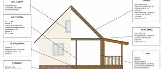
Indentations from the boundaries of the land plot during individual construction
Every resident of our country, while carrying out any construction work in their own home, thought about whether there were legislative norms that defined clear boundaries in buildings, distances between houses, and so on.
The legislation of the Russian Federation clearly regulates all norms relating to the construction of various buildings on its own, the main of which are: SNiP 2.07.01-89 Urban planning. Planning and further development of both urban and rural settlements; MSK-MGSN 1.01-99 clause 9.1; MO – TSN 30-303-2000 clause 10.15; Small-sized buildings: SP 30-102-99: Planning and further development of the Small-sized construction area, p.
5.3; Fire safety requirements: 123-F3, including sanitary SanPin 2.2.1/2.1.1.1200;
I.
The procedure for filling out general information on the urban planning plan of a land plot
Order of the Ministry of Regional Development of the Russian Federation of August 11, 2006
N 93 On approval of the Instructions on the procedure for filling out the form of an urban planning plan for a land plot In pursuance of paragraph 2 of the Decree of the Government of the Russian Federation of December 29, 2005 “On the form of an urban planning plan for a land plot” (Collected Legislation of the Russian Federation, 2006, N 2, Art.
205), I order: Approve the attached document on the procedure for filling out the form for the urban planning plan of the land plot.
Minister V.A. Yakovlev Registered with the Ministry of Justice of the Russian Federation on November 8, 2006.
Registration N 8456 Appendix on the procedure for filling out the form of an urban planning plan for a land plot This Instruction was developed in accordance with Article 44 of the Russian Federation and the Decree of the Government of the Russian Federation of December 29, 2005 “On the form of an urban planning plan for a land plot” and defines
Determining boundaries by coordinates
The coordinates of the boundaries are determined based on the data on the establishment of boundaries on the basis of a title document. The land surveying procedure involves, while maintaining the basic shape of the site, adjusting and clarifying the actual position of the boundaries on the ground in comparison with the data entered in the register.
That is, before drawing boundary lines along the coordinates of turning points, a preliminary stage of cadastral work is needed . Therefore, the customer submits a title document for the land plot to the geodetic company carrying out the work.
Based on this document, the contractor orders a cadastral extract with the information entered into the register. On the ground, the data specified in the cadastral information is verified with the actual use of the site.
In some cases, the information does not match, and adjustments have to be made, since the established procedure for using the plots is also taken into account. In this regard, the cadastral engineer can set new turning points, along which plots are demarcated and amendments are made to the cadastre records.
It is also possible to adjust boundary boundaries that have moved to the side as a result of the owners’ initiative. Thus, when surveying the coordinates:
- are determined;
- to be specified;
- change;
- are being restored.
So, by changing the existing boundaries, it is possible to add plots of land to an existing plot and register up to 10% of the land in relation to the total area of the land plot. And most importantly, by determining the presence of boundaries by coordinates, you can eliminate boundary disputes with neighbors.
Free legal advice online
The involvement of lawyers in legal disputes is due to the need to fully protect the personal interests of citizens.
As practice shows, citizens avoid legal assistance in order to save money, but in practice this is associated with high costs.
Even citizens with a lawyer's education do not always keep up with current changes in legislation, so it would be advisable to consult a qualified specialist.
The convenience is that consultation with a lawyer is free and online. Where and how to get free legal advice? is provided throughout the Russian Federation.
Citizens, residents of the state, as well as non-residents of the country who temporarily reside in the Russian Federation can take advantage of the support.
On approval of the form of urban planning plan for a land plot and the procedure for filling it out
In accordance with Part 9 of Article 57.3 (Collected Legislation of the Russian Federation, 2005, No. 1, Art. 16; 2020, No. 27, Art. 4306; 2020, N 11, Art. 1540) and approved (Collected Legislation of the Russian Federation, 2013 , N 47, art. 6117; 2014, N 12, art. 1296; N 40, art. 5426; N 50, art. 7100; 2020, N 2, art. 491; N 4, art. 660; N 22, Art. 3234; N 23, Art. 3311, Art. 3334; N 24, Art. 3479; N 46, Art. 6393; N 47, Art. 6586, Art. 6601; 2020, N 2, Art. 376; N 6, art. 850; N 28, art. 4741; N 41, art. 5837; N 47, art. 6673; N 48, art. 6766; N 50, art. 7112; 2020, N 1, art. 185; N 8, Art. 1245), I order: 1.
Moreover, lawyers can advise interested parties outside Russia, but only within the framework of domestic legislation.
Approve the attached: a) form of an urban planning plan for a land plot; b) the procedure for filling out the form of an urban planning plan for a land plot.2.
How to order an extract from the Unified State Register of Real Estate
I want to know the coordinates of the border of the land plot 66:41:0401013:53
How to convert these coordinates to GPS coordinates?
There are no GPS coordinates. This is a navigation system. you could just as well call the coordinates “GLONAS”. but it’s wrong to say that.
Hello, how can I order a statement about a public road? in Rosreestr the road is marked on the map, the owner of Vysotsky’s house No. 2 blocked the road with a fence, they contacted the administration of the village, Shushensky, the head of the village, V.I. Shorokhov. with the complaint the answer came that a scheme was used to remove the boundaries of land plot No. 2 on Vysotsky Street dated July 4, 1993. Based on the above diagram, the utility passage between houses No. 2 and No. 3 is not through. We always drove and walked along this road.
Hello Oksana! All cadastral areas are divided into cadastral plots. You can find the intersection of this road on the map. And this intersection must also be marked with a cadastral boundary. And if this site is registered. By clicking on it, you can find out its address and cadastral number. In this case, you can order an extract from the Unified State Register. If it is not demarcated, then it will be written in the window and you will have to contact the city planner in your city.
Forms of notifications approved by order of the Ministry of Construction of Russia dated September 19, 2018.
Declare invalid (registered by the Ministry of Justice of the Russian Federation on July 21, 2020, registration N 42935).3. This order comes into force on July 1, 2020.4.
No. 591/pr
[2] To be completed if the developer is an individual Appendix No. 3 to the order of the Ministry of Construction and Housing and Communal Services of the Russian Federation dated _______________ 2020.
No. ______ FORM Notification of the completion of construction or reconstruction of an individual housing construction project or garden house "__" ____________ 20__ ________________________________________________________________________ ________________________________________________________________________ (name of the federal executive body authorized to issue construction permits, the executive body of a constituent entity of the Russian Federation, the local government body) 1 .
Information about the developer 1.1 Information about the individual, if the developer is an individual: 1.1.1 Last name, first name, patronymic (if any)
Indentations from the boundaries of the land plot during the construction of non-residential buildings
Arbitration courts recognize buildings erected without compliance with the legislation on setbacks from the boundaries of the site and various buildings as illegal.
They lose their legal status and are subject to demolition. The developer must comply with the rules on setbacks in order to take ownership and register the premises. This is the only way he can sell, rent, or use it for his own legal production. The rules on setbacks are established by urban planning legislation, building codes and local laws. Contents When constructing non-residential premises on a land plot, you must be guided by: The norms of the Land Code on the types of land categories (articles and Land Code of the Russian Federation); The Town Planning Code and local town planning legislation (urban planning regulations of cities, towns)
How to determine whether the boundaries of your land plot require clarification?
You can find the current answer to the question as of June 15, 2020 in the post: “Why is land surveying necessary?”
We have already written in our “Questions and Answers” section that from January 1, 2020, by order of the Government of the Russian Federation, a ban will be introduced on any operations with land plots that do not have legally established boundaries. They cannot be sold, donated, bequeathed, etc. Even if you have in hand a certificate confirming the ownership of the land, it cannot be disposed of without first carrying out the procedure for establishing the boundaries of the land plot, that is, land surveying.
In the process of work, cadastral engineers and managers of our company are often faced with a question from applicants: “Is it necessary to carry out land surveying of my site?”
There are three simple criteria by which anyone can answer the above question; the only condition is to have in front of you an extract from the Unified State Register of Real Estate (hereinafter referred to as the EGRN) about the main characteristics of the land plot in question. This extract can be requested and received by any person at a multifunctional center (MFC) - for this you need to know the cadastral number (or exact address) and pay the state fee (for an individual the cost of the state fee is 400 rubles (Order of the Ministry of Economic Development of Russia dated May 10, 2016 No. 291 “On establishing the amount of fees for providing information contained in the Unified State Register of Real Estate”).
1 Sign:
On the first page of the extract from the Unified State Register of Real Estate in section 1 in the line “Area” the value is indicated in an exact number: (as shown in the figure below)
This suggests that the coordinates of the boundaries of the land plot are either not determined at all, or are determined declared - the value of the area is taken from the title or title document issued earlier - before the start of maintaining the state cadastre. Land plots, information about which is entered into the Unified State Register of Real Estate on the basis of such documents, have the status “current, previously recorded” (section 1 of the extract from the Unified State Register of Real Estate, line “Record status of the property”: (as below in the figure)
If the boundaries of the land plot are specified and do not require land surveying, then information about the area is indicated with error data: (as shown below in the figure)
2 Sign:
In section 1 of the extract from the Unified State Register of Real Estate in the line “Special notes” there is a sentence “The boundaries of the land plot are not established in accordance with the requirements of land legislation.” This suggests that land surveying is necessary: (as in the figure below)
3 Sign (optional):
If in your extract from the Unified State Register of Real Estate in section 3 “Description of the location of the land plot” there is subsection 3.2 “Information about the characteristic points of the border of the land plot”, then the column “Mean square error in determining the coordinates of the characteristic points of the borders of the land plot, m” should be filled with a numeric value.
Moreover, the accuracy values for determining the coordinates of characteristic points of the boundaries of land plots must comply with current legislation:
(Order of the Ministry of Economic Development of the Russian Federation dated March 1, 2016 No. 90 “On approval of requirements for accuracy and methods for determining the coordinates of characteristic points of the boundaries of a land plot, requirements for accuracy and methods for determining coordinates of characteristic points of the contour of a building, structure or unfinished construction site on a land plot , as well as requirements for determining the area of a building, structure and premises."
If the boundaries of the land plot are not established, section 3 will be completely absent. This will be confirmed by the data in the “Special notes” line of section 1:
However, if the land plot has declared boundaries, then subsection 3.2 will be filled in, but the column “Mean square error in determining the coordinates of characteristic points of the land plot boundaries, m” will have the value “no data”. Surveying required:
If you do not have an extract from the Unified State Register for a land plot at hand, then using a public cadastral map, knowing the cadastral number of the land plot, you can obtain primary information about the need to establish the boundaries of the land plot. If the boundaries require clarification, then the window that appears will contain the phrase “Without border coordinates” and/or the area will be listed as “declared”.
recommends drawing conclusions about the need to clarify the boundaries of the land plot based on the information available in the extract from the Unified State Register of Real Estate.
Setbacks from the boundaries of the land plot during construction 2020
› The setback from the boundary of the plot during the construction of a house is a SNiP standard and a necessary step that must be taken when developing a land plot owned by the owner on SNT or individual housing construction lands. The distance of buildings from the boundaries of the site is only an approximate value determined by incompetent sources.
It must be a minimum of 3 meters according to SNiP standards.
People who claim that it is enough to move away from the boundary by the required minimum for all requirements and standards to be met are deeply mistaken.
The amount of indentation may vary due to various circumstances. The Town Planning Code is a document mandatory for urban and rural settlements, stipulating the need to obtain permits before starting construction. With the help of a permit obtained from local authorities, you can not only determine the correct distance.
Permission to deviate from the maximum parameters of permitted construction - conditions and procedure for obtaining
→ → →
photo
documents application form documents for the application other application forms example of a resolution Contents: Limit parameters of permitted construction are one of the indicators of urban planning regulations.
The City Regulations, in turn. is one of the results of urban planning zoning of municipal territories, providing the solution to a number of problems:
- formation of territorial zones, establishment of town planning regulations operating within the boundaries of a specific territorial zone, establishment of the type of town planning activity
The goals of the formation of territorial zones are: creation