Formation of land plots
The formation of land plots in accordance with current legislation implies the registration of these plots with the state cadastral register.
As a result of cadastral work, a land plot (land plots) and parts of a land plot (land plots) are formed.
Cadastral registration confirms the existence of a land plot with its inherent properties and characteristics, making it possible to define it as an individually defined thing.
The characteristics specified during the formation of the land plot will subsequently determine its fate, taxation and permitted actions in relation to land use (construction, registration). The main characteristics of a land plot necessary when forming a land plot:
- land category;
- permitted use of the land plot;
- square;
- address;
- coordinates of the land plot;
Methods for forming land plots
If the boundaries of the plot were previously formed, but there is a need for adjustment, the formation of land plots is possible in the following way:
- Division of a land plot - several land plots are formed, and the land plot from which land plots are formed during division ceases to exist. The original land plot will be removed from cadastral registration after confirmation of rights to the resulting plots.
- Allocation of a land plot - is carried out in the case of allocation of a share or shares from a land plot that is in shared ownership. When a land plot is allocated, one or more land plots are formed. In this case, the land plot from which the allocation was made remains within the changed boundaries.
- Consolidation of land plots - one land plot is formed, and the existence of adjacent land plots ceases.
- Redistribution of land plots - several other contiguous land plots, and the existence of the original contiguous land plots ceases.
If the original land plots are registered in the cadastral register, but their boundaries are not defined in accordance with current legislation, you will first need to carry out a procedure to clarify the boundaries of the land plot.
Formation of plots from municipal lands
Often, the formation of a land plot means its allocation from state or municipal lands and its boundaries are established for the first time. Let's consider this method of education.
The basis for the formation of land plots from municipal and state lands is:
- Territory surveying project. In some cases, a site is formed solely according to a land surveying project.
- Layout of land plots on the cadastral plan of the territory, approved by the authorized body
- Project documentation on forest areas
Conditions for the formation of land plots
The size of the formed land plots should not exceed the maximum sizes of land plots provided for by the town planning regulations and should not be less than the minimum sizes of land plots provided for by the town planning regulations.
The maximum (maximum and minimum) sizes of land plots to which town planning regulations do not apply or in respect of which town planning regulations are not established are determined in accordance with the Land Code and other federal laws.
The boundaries of the formed land plots should not cross the boundaries of municipalities and (or) the boundaries of populated areas.
In the case of the formation of a land plot from state-owned lands, before cadastral work is carried out, a diagram of the location of the land plot on the cadastral plan or cadastral map of the corresponding territory is developed. The location of the boundaries of the land plot being formed in this case is agreed upon by the local government body.
Registration of rights to formed land plots
The basis for state registration of property rights and other real rights to land plots formed during the division, merger, redistribution of land plots or separation from land plots is:
- a decision on the division or consolidation of state or municipally owned land plots; an agreement on the division, consolidation, redistribution of land plots or allocation from land plots;
- another document on the basis of which, in accordance with this Federal Law and other federal laws, the formation of land plots is carried out.
Why us?
- we consult for free
- we work for results
- individual approach
- extensive work experience
- highly qualified specialists
- real terms
- certified cadastral engineers on staff
- geodetic work without intermediaries
- assistance in solving complex problems
Our cadastral engineers are lawyers in the field of land and property relations who have an understanding of the mechanism for generating and changing information about real estate. They see the problem as a whole, paying combined attention to both land and capital construction projects subject to cadastral registration and registration. In the field of view of a professional cadastral engineer there are numerous aspects that arise when registering land and property relations in order to obtain the intended result of cadastral work and prevent the occurrence of situations that contradict current legislation.
Source: https://kadastrovik.com/mezhevanie/obrazovanie-zemelnogo-uchastka.html
The problem of leasing part of a land plot
The legislation provides for the essential terms of the lease agreement.
So, by virtue of paragraph 1 of Art. 432 of the Civil Code of the Russian Federation, an agreement is considered concluded if an agreement is reached between the parties, in the form required in appropriate cases, on all the essential terms of the agreement. Essential are the conditions on the subject of the contract, the conditions that are named in the law or other legal acts as essential or necessary for contracts of this type, as well as all those conditions regarding which, at the request of one of the parties, an agreement must be reached.
obtaining pre-project justification for capital construction or temporary placement of non-capital facilities (general plan diagram, layout diagram, etc.).
This paragraph is applied when forming land plots for the construction, reconstruction of capital construction projects or temporary placement of non-capital facilities.) 1) The land plot must be formed in such a way that it is possible to ensure proper operation or construction of a capital facility, maintaining the inextricable unity of the land plot and the located (under construction ) on it a capital object.
Formation of a land plot
The formation of land plots is carried out by modifying old plots and forming new ones by decision of the authorities. To properly form an allotment, a number of requirements must be met.
In order to finally carry out the procedure for the formation of a new plot, it is necessary to register it with the Rosreestr of Real Estate and assign a number.
Grounds for the formation of plots
The formation of land plots occurs legally with the subsequent registration of new real estate in Rosreestr.
The following methods are provided for the formation of land plots.
- The formation of land plots that are not exploited and are under the jurisdiction of municipalities and government agencies.
- Artificial creation of land on water bodies that belong to the federation, by transporting or alluvial soil. The formation is recognized as a site after it is put into operation.
- Section – the possibility of forming several sections from one. The formation of land plots is provided by contacting a geodetic organization, which carries out land surveying, creating boundaries between new lands. The owner remains the former owner or several new beneficiaries (for example, due to the division of the plot by heirs), while the old plot is deregistered and ceases to exist.
- Allocation is possible at the request of the participant in shared ownership. He becomes the full owner of his share, and the old plot changes its boundaries.
- Association is carried out by concluding an agreement between the owners. It involves the cessation of the existence of several plots as separate objects owned. Subjects who previously owned plots, if they did not alienate their plots to other subjects, acquire the right of joint ownership of the land. An individual owner can also merge several of his plots by submitting documents to the registrar.
- Redistribution of plots between entities that own the land. Land plots are being formed with new boundaries by decision of the authorities. To do this, a whole mechanism is launched to identify the actual owners or those registered in Rosreestr, the presence of restrictions and encumbrances on the land. Subjects affected by the transformation must give their consent and go through the procedure of registering rights to the new plot.
New plots arise from already used lands when old plots cease to exist. Also, allotments are created in areas that have not yet been exploited, which are on the balance sheet of government agencies or municipalities.
When forming a new land plot, the requirements for the objects being created must be met:
- the dimensions of the site should not exceed the limits of urban planning regulations (except for established cases, for example, in relation to sites under natural objects related to cultural heritage, this criterion may not be met);
- the boundaries of allotments should not overlap municipal properties or intersect with populated areas, environmental zones, or mining areas;
- the formation of a land plot that will block the passage to buildings is unacceptable;
- the new object must be used in accordance with its intended purpose;
- Broken boundaries and wedging of plots must be avoided; the site must be convenient for the development of houses or other real estate.
There are certain requirements for land plots and their creation, violation of which can be appealed, since it interferes with the effective use of the land for its intended purpose.
When a new plot is formed, registration and registration of property rights occur at the same time.
The following documents are required for this:
- application of a person wishing to register a newly formed object;
- title documentation, if data on the real estate was not previously in the Real Estate Register;
- consent of other persons, if necessary;
- documentation issued as a result of land surveying and approval of its boundaries;
- permitting documents for commissioning;
- if the site is owned by shared owners, it is also necessary to provide a land surveying project, agreed upon between them, confirming the owners’ shares.
In the case where there are several entities that wish to change boundaries, redistribute lands or merge them, additional documentation must be submitted to the registration authority confirming the will of these owners.
Section and selection
The main difference between these categories is that during division the old site ceases to exist, and during separation it only undergoes changes.
The division can be carried out by the following entities:
- a person who is engaged in the comprehensive development of the territory under a contract;
- owners on the right of common ownership who have decided on their shares;
- citizens who are members of a non-profit organization (for example, such as a gardening society);
- Municipalities and government agencies can divide their lands.
Allocation for the formation of a land plot can only be made by shared owners, with the exception of those who have premises in an apartment building.
Division or allotment is impossible when the plot or buildings on it are indivisible, as this leads to loss of the integrity of the object or the inability to use it for its intended purpose.
When allocating or dividing land that was in co-ownership, everyone has the right to terminate co-ownership and demand their share.
The procedure for the formation of land plots obliges owners of real estate that are in joint ownership to first determine the shares that are due to each of them or those who wish to terminate joint ownership. The division of an allotment or allotment occurs as a result of an agreement or a court decision.
The formation of land that belongs to municipalities and government agencies is carried out within the old boundaries.
An entity that uses such lands legally (for example, rents them) submits an application in order to approve the location of the plot on the cadastral plan.
In addition, the applicant submits the scheme itself and copies of documents for the allotment, if it has not yet been registered in the Unified State Register of Real Estate. The authority has a month to refuse the land user or approve the scheme.
The legislator provides the opportunity for applicants to draw up a boundary plan themselves, which even applies to multi-circuit areas. These are lands that are located in one locality and consist of several plots. They may be separated from each other, have inclusions, and their boundaries may not have points of contact (for example, a private house and a plot of land are separated by a road).
When forming such an allotment, all parts are assigned a single number for cadastral registration. Transactions are carried out with such an allotment as a single whole.
The division and allocation of land plots requires mandatory state registration. New entities are assigned cadastral numbers, and the owners receive the right to dispose of the land and carry out legal transactions with it.
Consolidation of plots
Formation of land through association is possible by one or several owners. The former plots cease to exist and are registered in the name of one or more owners who own the formed plot on the right of common ownership.
The formation of land plots through association is a popular procedure for the following reasons:
- obtaining tax benefits is impossible for several plots at once;
- you cannot build a large house on two plots at once, as problems with its registration will follow;
- the price of a large plot increases when it is sold;
- for one owner there is no need to create separate packages of documents for real estate;
- reduction of land tax.
Requirements for merged areas:
- all plots must have the same legal status (for example, it is impossible to combine lands in perpetual possession and in inherited possession), except in the case when they are united by one person;
- plots must be adjacent;
- the boundaries of the merged lands must be precisely defined, in this case the cadastral engineer will not need to go to the site, he can draw up a land survey plan according to the existing schemes;
- plots must belong to the same category (for example, issued for settlement);
- sites may be located within the same administrative unit;
- new plots must meet all requirements for the formation of new land plots (avoiding wedging, size violations, etc.)
The procedure for the formation of land plots involves the submission of statements from all their owners about their intention to create one plot.
Consolidation of plots leads to common ownership and, as a result, to some restrictions, but this legal way of forming a new plot helps to solve many problems with taxation, sell land for more money, etc.
Redistribution
Redistribution of land is possible between state authorities and self-government bodies in certain cases.
- All redistributed lands are not in private use or ownership, are not under the jurisdiction of government authorities, and the interests of third parties are not extended to them (except for easements). The bodies between which the lands are distributed enter into an agreement, with the exception of the situation when the site is under the jurisdiction of one body - it can then unilaterally make a decision.
- Part of the lands subject to distribution belongs to the state or municipality, and the remaining lands do not belong to anyone and are not encumbered.
- Lands are redistributed by one body, which is in charge of all these lands.
The grounds are agreements between subjects, an individual decision, a land surveying project. All territory boundaries must be clarified and approved.
Cases when redistribution of plots belonging to the federation, municipality and private ownership may occur:
- carrying out comprehensive development of the territory in order to bring the boundaries of the plots in accordance with the drawn up land surveying projects;
- redistribution of plots in order to align their boundaries - is carried out only when expanding plots that belong to private owners;
- distribution of land between private owners is also carried out with the condition of expanding the boundaries of plots up to the maximum size;
- there was a need to seize land for the needs of the locality or the state.
The basis is agreements between the owners of the redistributed plots; documents from the Rosreestr are also required for these plots. In addition, the authorities provide an invoice, on the basis of which an additional payment is made for the fact that the site has increased.
For redistribution, a land surveying project or a diagram showing the location of the allotment is being prepared.
The municipality and government agencies can also transfer ownership of the plot free of charge. The list of cases of free transfer of land is exhaustive. For example, citizens with many children, religious and charitable organizations can obtain a plot without payment.
The transfer of ownership is regulated by law. Redistribution of land is allowed only if all conditions are met and on legal grounds, confirmed by the necessary documents.
Other cases of formation of sections
Part of the site is considered by law to be a separate land object.
The right to a part of the plot appears in the following cases:
- when acquiring ownership of a house or other building that is located on someone else’s land, the new owner receives rights to the private land plot where the building stands;
- when renting out part of the plot;
- if the easement does not relate to the entire site;
- when a part of the estate, including real estate, is encumbered (Rosreestr should have such information about the site).
In all the situations described above, the formation of a part of the land plot must be registered by entering information about it into the Rosreestr. To do this, you need to survey the territory, draw up a boundary plan with the help of specialists, and put part of the plot on cadastral registration.
Part of the plot is a separate type of land, its allocation must occur with notification of government authorities and registration.
Apartment owners are co-owners of the land on which such a house and buildings next to it are built.
Regarding land plots under multi-apartment buildings that were formed before the spring of 2005, or those that are already registered in Rosreestr, they belong to the apartment owners.
The formation of a land plot under an apartment building, if it is not included in the Rosreestr of Real Estate, requires active action on the part of apartment owners.
The format goes like this:
- a general meeting of apartment owners is held;
- a decision is made on the need to form a precinct and an authorized representative of the assembly is selected before various authorities;
- an application for registration of the site is drawn up;
- the selected person is sent to the registrar with an application, passport and documentation to confirm their right to own the apartment;
- the cadastral engineer is preparing a land surveying project;
- registration is carried out.
Until the plot is formed, apartment owners can use the plot to the extent necessary for the normal operation of the residential building.
Formation of a boundary plan
In the latter case, the listed designations are placed in a frame.
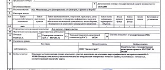
This work highlighted theoretical issues on the composition and content of cadastral and geodetic works in the formation of cadastral registration objects; the features of land surveying of cadastral registration objects were considered; the issue of forming a boundary plan is disclosed; The appendix provides an example of a boundary plan prepared as a result of cadastral work in connection with the formation of a land plot from lands in state or municipal ownership.
There are a number of legal and cadastral measures necessary for registering rights to a plot, as well as for conducting various types of transactions with this plot.
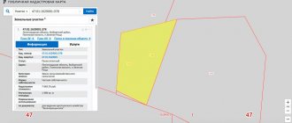
One of these mandatory measures in accordance with Article 45.1 of Federal Law No. 447 is the registration of a land plot with cadastral registration. Only after land surveying and registration of land in the cadastral register do government authorities have complete and accurate information about it.