All articles
18270
2009-03-13
When selling real estate, a subject may encounter a technical or registry error. The presented material will tell you how to correct the error in the location of the boundaries of a land plot on the cadastral map, in which cases your participation is required and in which it is not.
Manipulations carried out with square meters and land require the preparation of an accompanying package of documents. The owner must present an extract from the Unified State Register of Real Estate . The certificate displays information about real estate, land, owner, and procedures carried out with real estate.
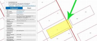
You can find a plot on a cadastral map, but the plot is not always displayed, which leads to a number of problems. The reason lies in a cadastral error.
Types of errors
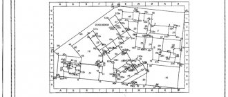
In order for the site to be displayed on the cadastral map , the owner needs to invite a land management specialist who carries out land surveying and draws up a technical plan. Based on the technical plan, representatives of the registration authority register the object for cadastral registration.
If a cadastral error is detected in the location of the boundaries of the land plot, other coordinates will be displayed on the map.
There are several types of errors, they are divided into technical and registry. Each species has its own subspecies.
Among the main cadastral errors of a land plot, the following should be highlighted:
- Irregularity of boundaries. By opening a thematic map, the subject may notice that its boundaries are superimposed on the neighboring area. Before correcting deviations from the norm, you need to obtain the consent of your neighbors and make sure that they have no complaints. This type refers to registry errors made by the engineer when entering data. To correct this, re-surveying is carried out.
- Incorrect boundaries of several memories. One area overlaps the adjacent one and the adjacent one is also displayed incorrectly. Correction of a cadastral error of a land plot is carried out using repeated land surveying (with the consent of all participants/neighbors).
- Neighbors do not agree with the established boundaries. When inaccuracies are discovered, it is not always possible to obtain the voluntary consent of neighbors to change the data. In this case, the owner needs to contact the courts; court representatives will cancel the existing decision to conduct the land survey.
- The satellite gives the wrong picture. If a cadastral error in the location of boundaries is associated with a shift in satellite photographs, all boundaries, not just one specific one, will be displayed incorrectly (outside their boundaries). There is no need to take any action; the coordinates in the documents are indicated correctly.
Important! If all the information is displayed correctly on a public map, but in fact the plot is larger, this is classified as illegal legalization. The owner may be held administratively liable for illegal actions. His actions are assessed as self-capture.
The first step to correcting the error is to order an extract from the Unified State Register of Real Estate to determine the exact boundaries and confirm ownership. You can order an electronic certificate on the official website: rosreestor.info
After carrying out the above manipulations, documents with new entered data are sent to the registration authority. It takes three to five business days to correct the error, depending on who made the inaccurate data.
Correction of a cadastral error in the location of the boundaries of a land plot
There is a procedure in Russian legislation through which incorrect data on the boundaries of a site can be corrected.
Consider several ways to correct information:
- Administrative solution to the problem. This method is based on involving the neighbors of the problem area in finding a way out of the current situation. In this option, cadastral engineers record the current position of adjacent boundaries between neighbors. They draw up a protocol and draw up a document to coordinate the adjacent boundaries of plots between their owners. Be aware that agreement between neighbors regarding plot boundaries is rare in practice;
- Judgment. The owner of the site can initiate the process by submitting an application to the judicial authority. The application must contain a request to the court to determine the boundaries of the property. There are two options for considering the issue in court: If the owner has a document on land ownership, then the following requirements must be indicated in the claim: Determine the boundaries of the territory;
- Correct information in the cadastral authority;
- Determine the coordinates of the boundaries of the site based on the data of the cadastral engineer who carried out the work to form the territory of the site;
- Requiring the court to recognize the user's rights to own land;
How to obtain a cadastral passport of a land plot online?
Read about market and cadastral valuation of land plots here.
How to order an electronic extract from the USRN for a land plot, read the link:
When using the judicial option to solve the problem without a certificate of ownership in relation to a piece of land, concentrate your efforts on proving the rights to own and dispose of the land.
To prove your right to the disputed territory, please provide the following information in your application:
- Details of the cadastral registration authority that carried out the registration of the site;
- Details of the owner of neighboring adjacent plots;
- Indicate the actual position of the borders, which will confirm the fact of crossing the borders of the territories;
- Information that an error was made regarding the site when drawing up a land survey plan;
- If there are permanent fences on the site for more than 15 years without moving them in relation to adjacent boundaries with neighbors, indicate in the statement that when fixing the boundaries between neighbors, this information was not used by the engineer in the calculations;
- Provide information that the presence of incorrect information is the reason that the owner cannot obtain a cadastral passport for a plot of land.
Most often, during a trial, the judge orders an examination in relation to the chosen method of correcting data on the boundaries of plots. Please note that in such matters the court may appoint a specific independent company that will carry out expert work and draw up an opinion.
The final document is the basis for the court to make a decision, a copy of which is transferred to the cadastral engineer. The engineer files this paper with the boundary planning documents.
If the court decision determines the coordinates of the boundary plan, which do not coincide with the data of the cadastral engineer, then he corrects the information, bringing it in accordance with the data that is in the court decision. The new plan drawn up on the basis of the data contained in the court decision is submitted to the registration authorities for inclusion in the state register.
If it turns out that distorted information about the boundaries between plots appears at the time of cadastral registration, then all work in this direction is suspended. Next, apply the above methods for correcting data using any method.
Most often, the procedure for correcting data on the boundaries of a plot is delayed due to the fact that the owner of the land plot does not submit an application to correct inaccurate data regarding the boundaries of the land plot. Another reason for delaying the process and bringing it to court is the reluctance of neighbors to participate in the coordination of boundaries.
Technical
Technical errors include typos made by employees of the Federal Service for State Registration, Cadastre and Cartography. To correct inaccuracies, you need to contact the registration authority. This type of inaccuracy includes:
- Typos.
- Incorrect numbers.
- Missing number of digits.
- Incorrectly entered address information.
- No information (incomplete information).
Government agency employees request archival data, compare it with available information, and make changes.
What is a cadastral error and the reasons for its occurrence?
The error occurs when employees of the state cadastre incorrectly fill out data from the original documentation. Most often, the reasons are related to the mistakes of the cadastral engineers who drew up the boundary plan. Nowadays, a cadastre error is usually determined, which is associated with a discrepancy between the actual location of the coordinates of the land boundaries established by the engineer.
Typically , a discrepancy occurs due to the fact that:
- for some reason, engineers do not go to the area, indicating in the plan only the approximate boundaries of the land. To substantiate the data, information about adjacent territories previously registered with the State Property Committee is used,
- often engineers who carry out land surveying work use outdated equipment and carry out land surveying in a local or conventional coordinate system, without taking into account the national system,
- Land management work is not always carried out carefully. Therefore, there are errors in a certain configuration of the barrier by the engineer, and miscalculations in calculations,
- Not all engineers have the necessary qualifications to properly prepare the equipment and correctly post-process the measurements taken.
Often cadastral errors are made by municipal authorities when drawing up acts that change certain technical characteristics of real estate, preparing draft boundaries of territories for cadastral work or during inventory work.
A technical error
This is an error (typo, typo, arithmetic or grammatical error, etc.) that was made by the cadastral registration authority during the maintenance of the real estate cadastre and led to data inconsistency.
It is corrected by decision of the cadastral registration body , when this body identifies this error or receives an application from any person, in the form established by the regulatory body in the field of cadastral relations, or on the basis of a court decision to correct this error.
In other words, employees of the accounting authority, while recording the unique characteristics of real estate, may make a typo, typo, arithmetic or grammatical error, which will be corrected when it is detected directly by the cadastral registration authority. Moreover, the law allows for the elimination of cadastral errors in data upon the application of any person. And only if the Cadastral Chamber, for certain reasons, refuses to correct the identified error, then the latter is eliminated in court proceedings.
Cadastral error
But, as a rule, crossing the boundaries of territories occurs as a result of a cadastral error, which is an error in the documentation reproduced in the state cadastre, taking into account which information was entered into the cadastre.
It is corrected in the manner established to take into account changes in a specific real estate object, if the original source of the error was the boundary plan, either in the order of information relations, or on the basis of a court order to eliminate this error.
Conventionally, cadastral registration of a territory goes through two stages:
- Drawing up a boundary plan and marking boundaries. Sending the boundary plan to the cadastral registration authority.
- Entry of real estate into the state cadastre by the cadastral registration authority. Data is taken from the boundary plan. Then a cadastral passport is given with information about the boundaries of the territory.
Typically, the intersection of territories is determined at the first stage - land surveying. There are two methods of correction: judicial and administrative.
How to fix it yourself
If you decide to personally deal with the elimination of inaccuracies, you need to understand how to independently correct the error in the location of the boundaries of the site.
All actions in several steps - filling out an application and submitting it to the government agency.
In order for the information to be corrected, you need to apply to the Federal Service for State Registration, Cadastre and Cartography. A neighbor who needs to obtain reliable data about the adjacent plot can also submit an appeal (before this, you need to order an extract from the Unified State Register of Real Estate ).
The application is submitted in writing in accordance with the procedure established by law. Experts recommend that you carefully fill out clause 3.1.2, which states where the error was made. After preparing the application, the application and package of documents are submitted to the registration authority.
If an adjacent one was superimposed on your area, you can eliminate the inaccuracies yourself. If an adjacent plot is placed on your plot, either contact the registration authority (if the neighbors are not against making adjustments) or through the court, if the neighbors refuse to make adjustments.
What is the procedure for correcting registry and technical errors?
There are different procedures for correcting registry and technical errors.
The state registrar reviews the message about the presence of a cadastral error and issues a conclusion on its correction. Three business days are given to review and correct the error. All interested parties must be notified (for example, neighbors whose interests are infringed by incorrect delimitation of plots). The period for such notification is only one business day. At the same time, the cadastral engineer who carried out the survey, or the employee who transferred the data from the survey plan to the Unified State Register of Real Estate database, is notified of any inaccuracies.
After this, Rosreestr employees must inform all interested parties in writing about the change in the entry.
IMPORTANT !!! The deadline for correcting a registry error is five business days. But again, if it does not entail a change in the scope of rights of the owner of the land plot.
The general period for making adjustments, including in cases where the activity of the copyright holder himself is required, is six months. After this period, correction of errors can only be demanded in court.
A court decision will also be required if:
- the cadastral engineer or other similar worker does not admit his mistake and is not going to admit it;
- the owner of the land plot refuses to recognize the information entered into the Unified State Register as erroneous;
- Rosreestr refuses to consider the appeal.
This list is not exhaustive; it may be supplemented by other circumstances.
The statement of claim contains:
- data of the plaintiff, defendant and 3rd party;
- description of the land plot;
- an indication of the basis of ownership of such a plot, including legal documents;
- essence of the complaint. It describes in detail what exactly the mistake was, when the land surveying, examination, etc. was carried out, its results, how this mistake needs to be corrected;
- list of attached documents;
- plaintiff's signature.
As judicial practice shows, most often cases are resolved in favor of the plaintiff. Therefore, this is an effective way to make adjustments to the Unified State Register.
What it is
Since 2013, on the territory of the Russian Federation, every property, including land plots, is subject to cadastral registration. This procedure consists of systematizing and summarizing data for each object and entering it into a single database - the Unified State Register of Real Estate. To carry out cadastral registration, the owner of a plot of land must submit a boundary plan, which has the following features:
- the boundary plan is prepared by a professional specialist - a cadastral engineer who has a qualification certificate and membership in a specialized self-regulatory organization;
- registration of the boundary plan is carried out on the basis of the cadastral work carried out, during which the engineer collects information about all the characteristics of the site (area, characteristic boundary points, etc.);
- By virtue of Article 14 of Federal Law No. 218-FZ, the submission of a boundary plan is one of the grounds for cadastral registration and registration of a land plot in the Rosreestr service.
Despite the high qualifications of cadastral engineers, errors may be made in the process of performing cadastral work and drawing up a boundary plan. If the distorted content of the boundary plan was transferred to the Unified State Register of Real Estate during cadastral registration, this violation is recognized as a cadastral error and must be corrected in order for reliable information to be entered into the register.
How has the correction of cadastral errors changed since 2017?
Also on the topic: Why do you need an extract from the ISOGD for a land plot?
Since January 2020, a new Federal Law No. 218-FZ has come into force, which regulates legal relations related to cadastral registration and registration of real estate rights. Article 61 of this regulatory legal act regulates the grounds and procedure for correcting errors in the information of the Unified State Register of Real Estate. With the adoption of Federal Law No. 218-FZ, the concept of a registry error was used, which in its legal content fully corresponds to a cadastral error.
Decision through court
Judicial practice has a sufficient number of cases on land and property disputes. Each case is special, and finding a similar case will be quite problematic. However, typical disputes can be found, as they are grouped into groups.
Disputes regarding inaccuracies are most often carried out on the following grounds:
- Refusal to register contributions at the request of the owner. Such refusals can be challenged through the courts, or with the help of the prosecutor's office.
- Challenging registered changes at the request of an interested party. For example, when the interests of the owner of adjacent plots were not taken into account.
- Delaying registration when the deadline for restoring technical data in the passport has already passed. For these contributions, employees have a period of 6 months, during which they must either register or refuse.
The claim for such disputes must be accompanied by documents indicating inaccuracies or objections to the information, extracts or passports found.
Disputes involving the presence of interested parties are more difficult to resolve, since they affect the boundaries of areas or the identification of those responsible, due to which inaccuracies were made. Sometimes property authorities are also involved in maintaining information about real estate objects, since, most often, it is their employees who allow various inaccuracies in documentation.
Owners disagree with changes
If it is necessary to enter updated information to replace distorted information, many property owners do not agree with this position. Some believe that they will have to pay state fees, write applications, stand in line and waste their time. However, some information, for example, when it is necessary to correct a technical error in a cadastral passport, can only be corrected at the property registration authorities. There is no need to change such distortions in Rosreestr, since it does not register such information. Technical data is important only to the real estate center.
Elimination of a cadastral error is sometimes associated with a change in Rosreestr documentation, since distortions may be made in the owner’s name, address and other important fields that are in the acts.
Not all owners will go for data recovery, especially if it leads to significant costs. So, for example, the construction of a house may take place on part of a neighboring plot, but previously this part was considered not to belong to this plot. If you deal with issues of the correctness of acts and passports, you will have to remove this part of the house, which leads to significant financial costs. Therefore, for some, correcting information will be a very difficult procedure.