CADASTRAL RECORDING OF UNIFIED LAND USE
There is no definition of single land use in land legislation. This concept arose as a result of the introduction of new technology for state cadastral registration of land plots. A number of Rosreestr documents give indirect concepts of unified land use.
The Decree of the Government of the Russian Federation “On Cadastral Division” and the order of Rosreestr say that several separate land plots occupied or intended to serve the elements included in one object, at the request of the right holder, can be put on state cadastral registration as one real estate object - a single land use with assignment of one cadastral number.
In the methodological recommendations “Features of registration of land plots occupied by production and technological complexes of power plants and electrical grid complexes for state cadastral registration” it is noted that several separate land plots representing a single land use, i.e. occupied by complex objects representing one thing, rights for which they are subject to state registration, are placed on the state cadastral register as one land plot with the assignment of one cadastral number.
The composition of a single land use is determined by the composition of the property located on the land plots. The property includes the main things and accessories. Accessory - a thing intended to serve another, main thing and connected with it by a common purpose, follows the fate of the main thing, unless otherwise provided by the contract (Article 135 of the Civil Code of the Russian Federation).
It is customary in the State Land Code to define single land use as a composite land plot consisting of incoming land plots (separate or conditional).
The classification of land plots by their types is as follows:
2. Composite plots (single land use):
Separate areas.
Conditional areas
A simple plot of land is not divided into plots; it is a single-circuit plot, the sign of which is one external border; any two points of the boundaries of a given land plot can be connected by a line without crossing the external border. A simple plot of land is located entirely in one real block.
A composite land plot (single land use) consists of separate and conditional land plots.
A separate land plot included in a single land use is multi-circuit and can be located in one or several real blocks. If a separate land plot is located in one cadastral quarter, then it is assigned the number of a real cadastral quarter.
If a separate plot is located in several real cadastral quarters, then it is assigned a number of a conditional cadastral quarter.
A conditional land plot is formed by the intersection of a composite land plot with a cadastral division line. This is a single-circuit land plot located in more than one real cadastral block. Such a land plot is assigned a number of a conditional cadastral quarter.
Unified land use has the following characteristics:
One legal owner of the land plot;
Unified use of real estate;
A unified legal regime for a land plot (the category of land and permitted use for all included land plots must be the same).
To form a unified land use it is necessary:
The presence of a real estate object located on the land plot, registered in the register as a single object of real estate;
Conditions for placing the object;
Single technological purpose of the property.
An accounting object (single land use) is formed in the following order:
1) determine the conditions for the formation of the object: the presence of registered rights and title documents for the land plot and real estate;
2) analyze the combination of objects: analysis of the possibility of combining land plots; sufficiency and necessity of the area of unified land use;
3) analyze the maximum dimensions of the land plot;
4) choose the option of describing the land plots (based on the results of land surveying or according to the declaration);
5) choose (justify) the best option for organizing unified land use.
Applications for state cadastral registration of unified land use are submitted for the purpose of:
Assigning a cadastral number to a property;
Registration of rights to real estate;
Registration of land rights and encumbrances.
Preparation of a description of a land plot representing a single land use has the following features:
Drawing up several descriptions of land plots - one for a composite land plot and several for included land plots;
The cadastral basis of a drawing of land plots contains a fragment of a conditional cadastral quarter, the boundaries of which coincide with the boundaries of the cadastral district, as well as land plots included in a single land use within this fragment;
The “description of boundaries” section is not filled in;
In the “information about land plots” section, information about a single land use is displayed in one subsection, which includes forms F.1.1, F.1.1/s and F.1.3;
Filling out form F.1.1 for each group of land plots for which a separate description of land plots is compiled, in each form the cadastral number corresponds to the cadastral number of the cadastral quarter;
In form F.1.3, a special note is made that the single land use is located on a certain number of land plots.
During state cadastral registration of land, a cadastral number is assigned to a single land use in the formed conditional cadastral quarter. The number of the single land use in the conditional cadastral quarter will be 0001. When creating a register of cadastral numbers for the conditional cadastral quarter, lines for state-owned plots are not reserved.
State cadastral registration of a land plot consisting of several separate plots representing a single land use is carried out by:
If it is located on the territory of one cadastral region;
If it is located on the territory of one cadastral district.
During state cadastral registration, information about unified land use is entered into a conditional cadastral quarter.
The right to a composite land plot (to single land use) is subject to state registration. The right to incoming land plots is not registered, since incoming land plots are not independent objects of real estate. Therefore, during state cadastral registration in full, form F.1.1 is filled out only for single land use.
When opening a subsection of the state register of lands of a cadastral region, which reflects information about the land plot occupied by the complex, it is mandatory to enter and fill out the forms of the State Land Register of the Kyrgyz Republic “General Information” (F.1.1) and “Information on Parts and Encumbrances” (F.1.3), at the same time, the form of the State Property Development Agency of the Kyrgyz Republic “Land Plot Boundary Plan” (F.1.7) is not filled out.
The cadastral plan of a land plot is drawn up only for single land use.
A single land use is
a composite land plot that has one cadastral number, but consists of several separate parts that do not have common boundaries. What actions can be taken with such a plot and what name it received after changes in land legislation will be described in our article.
Issues of legal regulation of unified land use and its division
The introduction of the concept of “single land use” dates back to the time of the Federal Law “On the State Land Cadastre” No. 28-FZ of January 2, 2000. There has been a long debate among legislators about the possibility of recognizing a land plot as a complex object, which may include several parts. And finally, the Government of the Russian Federation adopted a resolution approving the Rules for the cadastral division of the territory of the Russian Federation No. 660 dated September 6, 2000 (8 months after the adoption of Law No. 28-FZ), which introduced the concept of “composite land plot” into use, which later received another the name in the cadastral plan is “single land use”.
From this moment on, the owner of several separate plots could register them as one piece of real estate and receive one cadastral number for it. The rules for recording single land uses were later clarified in orders of Roszemkadastr No. P/206 of August 26, 2003 and No. P/119 of June 15, 2001. In the future, the owner could dispose of both the composite plot as a whole and its individual parts, for which purpose a division of single land use was previously carried out. The status of a composite plot was retained if at least 2 separate plots remained in a single land use after the division.
Clarification of the unified land use act of approval
Let's start filling out the information from the “Title Page” section. Fill in the required field “! 1. The boundary plan was prepared as a result of carrying out cadastral work in connection with "(required fields are marked with the sign "!"), we will enter information about the customer, information about the cadastral engineer, which are filled out in a separate form that opens when you click on the "Fill" button, then fill in the details “*Date of cadastral work”. The program will remember information about the cadastral engineer for the next land survey plan.
When drawing up a boundary plan to clarify a single land use, many questions and doubts arise. In this article we will show how to create a boundary plan to clarify a single land use with the inclusion of newly formed areas with clarification of adjacent areas. As a tool, consider the “Polygon: Boundary Plan” program, with which you can quickly and easily create a boundary plan of any complexity.
When were unified land uses created?
Order No. P/119 determined that a single land use may include conditional and isolated areas. Isolated areas do not have common boundaries and can be separated by other areas or linear objects (for example, roads). In this case, conditional ones mean those that have an adjacent border, but at the same time belong to different cadastral quarters.
For reference: a cadastral quarter is a unit of division of territory. The entire territory of the Russian Federation is divided into districts, districts into districts, districts into blocks. A cadastral district usually coincides with the territory of a constituent entity of the Russian Federation, a district coincides with the territory of an administrative-territorial unit of a constituent entity of the Russian Federation, and blocks coincide with the territories of small settlements or city blocks.
For the convenience of the owner, several land plots, upon his application, can be combined into one composite plot. Then it becomes easier to manage, and from a taxation point of view, unified land use is more convenient for calculating the amount of mandatory payment to the budget.
Don't know your rights?
What are composite sections called now?
Federal Law No. 28-FZ ceased to apply with the entry into force of the new federal law “On the State Real Estate Cadastre” No. 221-FZ of June 24, 2007. Along with it, a new concept appeared in land legislation - “multi-circuit plot”, replacing the wording “single land use”.
In addition, the Government of the Russian Federation, by Resolution No. 469 of June 14, 2011, declared its own Resolution No. 660 to be no longer in force. Although the principles of territorial division were preserved, certain terms were replaced. The new rules were reflected in the order of the Ministry of Economic Development No. 144 of April 4, 2011.
Important! From January 1, 2020, a new procedure for cadastral division of the territory of the Russian Federation, approved by order of the Ministry of Economic Development No. 877 of November 24, 2020, is being introduced.
The concept of multi-circuit assumes that each individual section has its own closed circuit. A multi-circuit section contains several sections with closed contours. Despite the apparent similarity with single land use, there are a number of differences:
- The single land use included separate plots, which could also have their own cadastral numbers. Individual contours within a multi-circuit area are not real estate objects, they are simply territories delineated by the boundaries.
- Contours cannot have common boundaries, but a single land use could include conditional (adjacent) areas.
Because of these differences, areas previously recorded as single land uses are not renamed as multi-contour areas, but continue to exist under the same names and with the same characteristics in the cadastre.
Features of preparing the MZU boundary plan
Every owner of a multi-circuit plot should know that without a boundary plan containing complete information about all parts of the plot, he will not be able to assign an individual cadastral number to the property.
Please note that such a plan contains a graphic and text part. The first describes the exact location of the site and its boundaries, the second describes information for the State Real Estate Cadastre and coordination of the position of the boundaries of the property.
In relation to the MZU, one boundary plan is drawn up, regardless of the number of cadastral blocks within the boundaries of which it is located. The plan can be drawn up in one copy:
1 when one plot of land was divided into several plots;
2 when redistributing several plots;
3 when several plots were formed when a share was allocated from a common property;
4 when the allotment and its parts are formed simultaneously;
5 if, together with the formation of the site, the data of other parts are clarified;
6 when several plots of one MZU were formed simultaneously;
7 when at the same time information about the plots of the site and the location of their boundaries is clarified;
8 if several new plots have been formed and as a result it is necessary to clarify the location of the boundaries of adjacent plots.
https://www.youtube.com/watch?v=https:accounts.google.comServiceLogin
The structure of the boundary plan has five points: title page, content, text part, graphic part (location diagrams of each site and geodetic constructions, drawings of allotments and outlines of control points for all boundaries of the MZU), appendix.
The content of the MZU boundary plan depends on how the site was formed. Thus, if a multi-circuit plot is formed by the union of several lands, then the plan indicates introductory information, information about the formation of the plot and its parts, data on the plots through which access to the MZU is provided.
If the MZU was formed through the allocation, redistribution or division of plots, then the content describes the formation of plots and their parts, as well as information about the plots through which parts of the plot can be accessed. Please note that if a boundary plan is created for an allotment that was formed by dividing one plot, then the document must indicate information about the converted plots or their parts.
We invite you to familiarize yourself with Public land relations
If the owner of the municipal land plot plans to draw up a boundary plan to clarify the area or boundaries, then clarifying information about the land plot and its parts is indicated. When a boundary plan is needed only to assign a cadastral number, then data on the formed parts is added.
The document must also contain an official conclusion from a cadastral engineer if the specialist has discovered inaccuracies in the location of the boundaries or disputes have arisen in the location of the plot, which was allocated at the expense of a share from the joint right of ownership.
How can unified land uses be transformed?
As mentioned above, new unified land uses are no longer being formed, but the already registered owners need to be disposed of somehow. The procedure for dealing with them is partially described in the letter of the Ministry of Economic Development No. 22409IM/D23 dated December 22, 2009, which explains how new areas are formed from single land uses.
According to this document, unified land use is recognized as a possible source of formation of new land plots. This may happen:
- by combining a single land use with an adjacent plot;
- in the course of redistribution between a single land use or a single land use and a regular plot;
- as a result of the allocation of a site from a single land use.
In this case, either a multi-circuit section or a regular section is formed. For example, a plot that previously divided it into two parts was added to a single land use, as a result of which the plot acquired one contour, a regular plot is obtained. If several contours remain after joining, the section will be called multi-circuit. In this case, in any case, after the described actions, from the moment of registration of rights to new plots, the original single land use ceases to exist.
Thus, unified land uses are
a type of site that is no longer formed but still remains in use. The legislator did not rename or change the status of the already recorded component plots, therefore, plots called single land use remained in the ownership of individual landowners. There are no restrictions on their disposal: they, like ordinary ones, can be freely given, sold or left as an inheritance.
Single land use is a term used to refer to an area of land divided into several contours by public structures or areas, but owned by a single owner.
This concept appeared relatively recently, but its use significantly simplifies record keeping in the cadastre. If the allotment has been assigned the status of single land use, then both the entire allotment and each individual part of it receives a cadastral number. At the same time, individual parts are not subject to civil relations and cannot be sold or leased separately from the total area.
A single land use can consist of both completely separate and conditionally separate areas. They differ only in the location of the contours.
The boundaries of completely separate parts are adjacent to territories that are not part of a single land use, and conditionally separate areas are adjacent to the remaining cadastral units of a single land use. Examples could be large agricultural or horticultural associations that have many plots of land separated by roads or other areas that do not belong to them, or a summer resident whose vegetable garden is located across the road from the house.
Multi-circuit land plot
Advice from lawyers:
1. A multi-circuit plot of land is made up of agricultural land, but the tenant does not cultivate it all, is it possible to terminate the lease agreement?
1.1. It is possible, under the conditions established by the parties to the agreement, by agreement of the parties or on the grounds specified in Art. 451 Civil Code of the Russian Federation.
Did the answer help you?YesNo
1.2. Good afternoon, if the specified condition is provided for in the contract, then yes, it is possible.
Did the answer help you?YesNo
Consultation on your issue
8
Calls from landlines and mobiles are free throughout Russia
2. The participants in the common shared ownership made an allocation on account of their shares. The allocation was made not as a multi-circuit land plot, but as 19 separate ones. Today, each owner has 19 certificates, which creates problems when registering an inheritance or when registering a transfer of rights. If there is any way to change 19 certificates to one?
2.1. I would advise you to first draw up an agreement on the division of inherited property. According to which the rights to the heirs would be transferred not to a share of the land plot, but to land plots, the boundaries of which could later be combined. For example, if the inheritance is divided between 4 heirs, then three heirs receive 5 plots each, and the fourth heir receives 4 plots. Naturally, when dividing land plots, the interests of each heir must be respected, both in terms of area and location of the land plot. In the future, if the boundaries of 5 separate sections coincide, then it will be possible to combine them into one section through a certain procedure.
Did the answer help you?YesNo
3. A lease agreement for a multi-circuit land plot was concluded between the district administration and 4 individual entrepreneurs-peasant farms. Each tenant has its own contours. One of the tenants decided to sublease his land plot. Question: Is the consent of the remaining tenants required under the contract if a notice of sublease is submitted by one of the tenants.
3.1. Hello! No, it is not necessary if the lease agreement provides for sublease.
Did the answer help you?YesNo
4. Is it possible to register ownership (purchase at a preferential cadastre cost of 3%) for a multi-circuit land plot under a house in the Moscow region? The lands of settlements are both plots in one settlement. Point, the only problem is that there are 7 acres around the house, and 5 acres across the road from the house. I have been using all this land for a long time, no one objects to the use. Thank you.
4.1. Hello. Get consent.
Did the answer help you?YesNo
5. I own a house, the land under the house is not registered. I use a plot of land of 7 acres near the house and 5 acres across the road. Can I buy at a preferential cadastral value (in the Moscow region this is 3% of the cadastral value) as a multi-circuit land plot with an area of 12 acres from the municipality (land of settlements) or in the Moscow region this cannot be done and only 7 acres will have to be registered? Thank you.
5.1. Hello. According to Article 424 of the Civil Code of the Russian Federation.
Did the answer help you?YesNo
6. When surveying in 2013 a multi-circuit land plot previously registered in 1995, the plot was assigned the number of another cadastral quarter (the quarters are not adjacent, for example: the number on the old certificate was 00 005, became 00 007 in the new one). How legal is this, when the numbering of cadastral blocks in the region was clarified and on the basis of what documents.
6.1. They are constantly changing, and the accounting system is being improved. What difference does it make to you, what depends on it? In general, the 1997 numbers have been changing for a long time since 2002. This was the first change in the cadastre.
Did the answer help you?YesNo
7. The property has a multi-contour plot of land, land surveying was done, they refused to clarify the area of 3 contours, the area decreased by more than 10%. appealed to the court for recognition of ownership of land of a smaller area. The judge asks for clarification in favor of whom we are giving up the other area.
7.1. Well, refuse in favor of the local government.
Did the answer help you?YesNo
7.2. Involve the local government body as a third party in the matter and refuse. If he takes that part. Which you refuse.
Did the answer help you?YesNo
7.3. If you own a multi-circuit land plot, then your claim for recognition of ownership of the specified land plot, but of a smaller area, should be denied, since the legislation provides for other procedures to resolve the issue at hand...
Did the answer help you?YesNo
Transformation of single land use
When dividing a single land use, only the official owner of the plot can act as an initiator. The exception is separation based on a court decision.
After the transformation, the plots of land are assigned new cadastral numbers, but for the original plot within the changed boundaries the number remains. If, after the division, two or more land plots remain as part of a single land use, they are assigned the status of a multi-contour plot. This formulation is due to the fact that about ten years ago the creation of unified land use was abolished, but since the law does not have retroactive effect, the existing unified land use still remains in use.
A single land use can be transformed into a multi-circuit plot not only by division, but also by merging with neighboring plots.
Multi-contour land plots containing two or more plots, in contrast to single land use, are given one cadastral number. Based on the peculiarities of their formation, multi-circuit plots can have separate contours or interspersed.
Before carrying out any transactions, as well as to accurately determine the existing boundaries, the unified land use is clarified. The process takes place by comparing the data in the cadastral documentation with the actual characteristics of the plot.
In order to carry out the division of unified land use in 2020, different methods can be used, based on property rights and other specifics.
Dear readers! The article talks about typical ways to resolve legal issues, but each case is individual. If you want to know how to solve your specific problem
— contact a consultant:
APPLICATIONS AND CALLS ARE ACCEPTED 24/7 and 7 days a week
.
It's fast and FREE
!
In this material we will tell you what the division of unified land use is, for what purpose it is carried out, the list of documents for this procedure and which government agency is dealing with this issue.
Cadastral Engineers Forum
Question: About the division of previously registered land plots, which were given the name “single land use” during state cadastral registration; on the legality of decisions taken by cadastral registration authorities to refuse to carry out state cadastral registration. Answer: MINISTRY OF ECONOMIC DEVELOPMENT OF THE RUSSIAN FEDERATION LETTER dated March 2, 2010 N D23-671 The Real Estate Department of the Ministry of Economic Development of the Russian Federation considered an appeal regarding the division of previously registered land plots (hereinafter referred to as the original land plot), which were given the name “single” during state cadastral registration land use" (hereinafter referred to as unified land use), and reports. In accordance with the Regulations on the Ministry of Economic Development of the Russian Federation, approved by Decree of the Government of the Russian Federation dated 06/05/2008 N 437, the Ministry of Economic Development of Russia is not vested with the authority to explain the legislation of the Russian Federation, as well as the practice of its application. At the same time, we believe it is possible to note the following regarding the issues raised in the address. The specifics of the unified land use section are established by clause 60 of the Procedure for maintaining the state real estate cadastre, approved by Order of the Ministry of Justice of Russia dated February 20, 2008 N 35 (hereinafter referred to as the Procedure). In accordance with this paragraph, when dividing a single land use, the formed land plots are assigned new cadastral numbers, and the original land plot (single land use) remains with the same cadastral number within the changed boundaries (changed land plot). It should be noted that the above rule applies only if, after the transformation of a single land use, at least two land plots remain in its composition. The Land Code of the Russian Federation (hereinafter referred to as the Code) and Federal Law dated October 25, 2001 N 137-FZ “On the entry into force of the Land Code of the Russian Federation” (hereinafter referred to as the Law) establish the following cases when, as a result of the transformation of the original land plot, one or more land plots, while the original land plot remains within the changed boundaries: - when dividing a land plot provided to a horticultural, gardening or dacha non-profit association of citizens (clause 4 of article 11.4 of the Code); - when allocating a land plot on account of shares in the right of common shared ownership of the original land plot (clause 1 of Article 11.5 of the Code); - when dividing a land plot that is in state or municipal ownership and provided to a citizen or legal entity (clause 18 of Article 3 of the Law). In relation to these cases, the current legislation does not provide for mandatory cadastral work to clarify the location of the boundaries of the changed land plots. Thus, when creating land plots in the above cases, clarification of the boundaries of the original land plot, including single land use, is carried out at the request of the customer of cadastral work. Additionally, it should be noted that parts 2 and 3 of Art. 24 of the Federal Law of July 24, 2007 N 221-FZ “On the State Real Estate Cadastre” (hereinafter referred to as the Cadastre Law) established that in the case of the formation of land plots as a result of a division in which the converted land plot is retained within the changed boundaries, the cadastral registration authority An application for registration and the documents necessary for cadastral registration are submitted only in relation to the land plots being formed. Accounting for changes in the converted (original) land plot, which remains within the changed boundaries, is carried out without an application within three working days from the date of state registration of rights to the land plots formed from it. On the issue of the legality of decisions made by cadastral registration authorities to refuse to carry out state cadastral registration (hereinafter referred to as decisions on refusal), it should be noted that the grounds for making decisions on refusal are established by Art. 27 of the Cadastre Law. At the same time, Part 13 of Art. 27 of the Cadastre Law provides that the decision to refuse can be appealed in court. Additionally, we inform you that the position of the Ministry of Economic Development of Russia on the specifics of preparing documents necessary for the implementation of state cadastral registration of multi-circuit land plots, the implementation of such registration and the provision of information from the state real estate cadastre on multi-circuit land plots was communicated to Rosreestr by Letter dated December 22, 2009 N 22409-IM/D23 .
Deputy Director of the Real Estate Department V.V. ABRAMCHENKO 03/02/2010
Basic moments
Single land use is actually a plot of land with an assigned number according to the cadastre.
This plot consists of two or more plots, separated by borders and having unique properties.
The dimensions of such plots add up to the area of the total plot in accordance with the register. The division of a common plot can be carried out for various reasons, which we will now consider.
For example, if it is necessary to separate certain lands, a separate one is formed for them.
It is submitted to the cadastral authority for approval along with a boundary diagram for plots remaining as part of the general plot.
What it is
This concept is applied in cases where the plots are divided, but they have a common property and a common owner.
Each piece is characterized by separate boundaries and geodetic parameters. Geodetic information can be combined.
The plots are divided into 2 types:
- conditionally isolated;
- isolated.
The main difference is the location of the boundaries and the presence of adjacent contours. Conditionally isolated plots are not separated by contours.
Such areas in most cases are adjacent to neighboring lands that are not part of a single land use.
Conditional plots of land in all cases are called adjacent, since they are located in close proximity to neighboring plots of common land use.
However, they are separated by existing borders. Basically, the status of single land use is used in gardening cooperatives and associations.
After all, gardeners often own plots that are geographically located far from each other.
Each individual plot is assigned a personal cadastral number in the state register, while they are all included in the statute of unified land use.
In previous years, large agricultural farms and enterprises owned huge plots of land, which were divided into completely separate ones. That is, without adjacent borders and contours.
Legal standards
Legal regulation of this issue is carried out on the basis of federal legislation relating to state cadastral registration (procedures for issuing cadastre numbers to plots, orders for dividing plots according to the cadastre).
The main law in this area is, as amended on July 13, 2015.
According to this law, today the status of single land use is not assigned, since instead the concept of a multi-circuit plot was introduced.
As of 2020, this concept has become a replacement for a single site. The territories fell under a single allotment until 2007, that is, until the law was adopted.
Until today, they have not been transformed, so the previous concept can be applied to them. The previous regulations also apply to them.
The main innovation when using the concept of multi-contour plots was the modified classification of such plots and the absence of personal cadastral numbers for isolated plots.
That is, a general cadastral number is issued exclusively for the entire multi-circuit area.
What does single land use mean?
The concept of unified land use was used to improve the quality and convenience of maintaining state cadastral records.
Thus, the accounting process was simplified, because it was possible to see both the general cadastral number of the entire plot and its individual component parts.
Who is the owner
Many land plots owned by private individuals or any associations are divided into divided pieces and plots without common boundaries.
However, all these plots are owned by one person, who is the owner. Let's look at an example.
A large plot of land in a village belongs to one owner, but on one piece of land there is a house and various outbuildings, and on another plot there is a vegetable garden and garden.
Moreover, these two sections are separated by a village road or run along the borders of the settlement. The owner of these plots is the same.
This plot of land may be divided by a road or an area with municipal buildings, but the entire plot of land is in the possession and use of one person.
The division of single land use owned by one owner is also observed among agricultural enterprises, the plots of which can occupy large areas.
However, these areas may be separated by public areas that are not owned by the enterprise.
How to select a section from it
Each plot that is part of a single land use has a unique cadastral number.
In order to separate it from the general allotment, it is necessary to contact the cadastral chamber with a corresponding application and indicating the reason for allocating a separate plot.
It is also required to provide the entire package of documentation for land ownership, including a boundary diagram indicating the exact coordinates and boundaries of the allocated plot.
When considering a multi-circuit plot, it should be taken into account that it is formed by connecting individual plots of land with their own closed boundaries.
Such plots are divided depending on the subjects of formation and are interspersed or with separate boundaries. Areas with separate contours are tightly connected to each other.
Based on this, today allotments in general land use are assigned the status of multi-circuit allotment.
If it is necessary to separate one or several pieces from a single land use, they are registered as completely independent plots.
And the remaining lands are undergoing the registration procedure as a multi-circuit plot.
It is possible to combine several land plots by creating a boundary diagram, which must be submitted to the territorial executive body.
This boundary plan must be reviewed and approved by the local government authority.
Areas located within a single land use are characterized by their own boundaries and geodetic parameters.
However, it is possible to combine them, select one or more sections from the total area, and clarify the boundaries.
Looking at the boundary plan
Clarifying the boundaries of a single land use involves the formation of a boundary plan, where it is necessary to enter data on existing plots.
As a result of the clarification process carried out by employees of the cadastral authority, appropriate amendments and changes can be made to the cadastral passport of the site.
Also, based on the results of clarification, areas can be combined, divided or separated. Employees have the right to correct other characteristics included in the cadastral passport of the site.
Often in a single land use there is a need to clarify boundaries using various methods. In this case, specially developed computer programs will come to the rescue.
With their help, it becomes possible to create a detailed and correct boundary plan required for clarification.
Today, many programs have been developed that have an intuitive control panel and will allow even beginners to cope with this task.
To create a boundary diagram, you just need to fill out a few spreadsheets, and in the end you will receive a detailed diagram according to the specified parameters.
Video: different cadastral values of nearby land plots
In order to use this option, after installing the program, you must enter detailed data on the site - the number according to the state cadastre, the number of pieces as part of a single land use, exact coordinates and other information.
Based on the information provided, the application will generate a detailed boundary plan.
The allotment boundary scheme is used in a situation of division of single land use. First of all, the features and specifics of the site must be taken into account.
However, each individual case is considered by the territorial executive body on an individual basis.
Therefore, in this process, special attention must be paid to communication with responsible employees of the cadastral institution.
Documenting
In some cases, it is necessary to redistribute unified land use with lands, or clarify the unified land use.
Employees of the territorial cadastral authority perform a comparative analysis of information from documents and the actual parameters and characteristics of the specified land plot.
The clarification procedure is used to identify the exact coordinates of boundaries or when creating new land plots, when disbanding them and separating individual pieces.
For all these procedures, you must contact the cadastral chamber with the following documents:
- certificate of ownership of the plot;
- personal documents of the owner;
- land cadastral passport;
- boundary diagram;
- an application with correctly filled in data and the purpose of registration.
In the process of clarifying the data, employees create a new boundary plan, which includes information about existing plots.
A single land use is an allotment that is divided by social facilities or public areas. That is, a single land use is a plot that consists of several pieces of land. Moreover, each piece of land has a personal cadastral number, as well as separate contours.
Clarification of the boundaries of the MZU
There are several circumstances for clarifying the boundary of a multi-contour section:
1 when the area of the site or its location does not correspond to the information available in the State Property Committee;
2 when the State Control Committee has no information about this site at all;
3 when the boundaries of the site intersect.
Owners, landowners, persons who have the right to use the land indefinitely, as well as official representatives of the owners can submit a request to clarify the boundaries of the MZU. To clarify the boundaries, the applicant must have a certificate of ownership, a decision to transfer the plot into ownership, or any other document that can confirm ownership of the property.
The process of clarifying the boundaries or area of a multi-contour area is a step-by-step implementation of certain actions, namely:
1 Study of documents confirming ownership of MZU (checking for any errors, checking the need to clarify the address reference, whether it is necessary to change the type of permitted use).
2 Carrying out geodetic measurements (the presence of fencing and other objects should be taken into account).
3 Approval of the act of approval of boundaries (mandatory signatures of the owners of adjacent plots).
4 Carrying out a boundary plan by a cadastral engineer.
5 Registration of the boundary plan in the cadastral registration service.
6 Obtaining a cadastral passport or extract.
Of course, clarifying the boundaries is not a simple procedure, but it will be simplified if the neighbors in the area have previously carried out the same procedure. Pay attention to this!
We invite you to familiarize yourself with the Documents for entering into an inheritance and registering a land plot
The legislative framework
The term single land use implies a certain number of separate pieces of land that form one plot. Each piece of land has personal boundaries, a cadastral number, as well as geodetic data. In addition, geodetic data can be combined.
Also, land plots are divided into 2 types:
- conditionally isolated;
- isolated.
The main difference between them is the location of the contours. Conditional land plots do not have a so-called contour. It is usually adjacent to neighboring areas that are not included in the EZ.
All conditional land plots are called adjacent. Because they are located near neighboring areas of the EZ. But at the same time, they are separated by existing borders.
Most often, the status of single land use is assigned to the lands of gardening partnerships and associations. Gardening partnerships often own land plots located separately from each other.
Each individual land plot of a gardening partnership has a corresponding number in the state land cadastre.
At the same time, they fall under the status of single land use.
Previously, large agricultural associations and enterprises owned large plots of land, which in turn could be divided into separate plots. There are many examples when lands were assigned the status of single land use.
Procedure for assigning status
very simple. Therefore, it is not difficult to determine the status of this or that piece of land. But since the concept of multi-circuit sections was introduced in 2007, it is necessary to correctly determine the status. Since these concepts have a number of fundamental differences. First of all, different legal frameworks are used. But at the same time, the accounting system is almost similar.
Termination of unified land use
To resolve disagreements in the regulatory sphere, it is carried out with the help of various regulations (orders on the division of land, cadastral number and other documents). This legal regulation is carried out in the field of state registration of land plots. As a rule, various legal instruments are used for legal regulation in the field of land use. State Law No. 221 is one of the legal instruments for regulation in the field of electronic health.
To date, EZ status is not assigned
, since in 2007 state law No. 221 came into force, according to which the concept of multi-circuit sections was introduced. Today this status is an alternative to EZ. Consequently, EZ status was assigned to lands until 2007. Land plots that fell under the definition of Unified Land Use were not transformed until 2007. Therefore, today they fall under this status.
Arbitrage practice
A multi-circuit plot is formed if there is a need to combine several land plots that have their own closed contours. In addition, areas can be classified according to the subjects of formation. There are two types of formations - interspersed and isolated contours. Allotments with separate contours fit tightly to each other.
Based on this, it follows that today lands that fall under the EZ status are assigned the status of multi-contour plots. If necessary, you can separate several pieces of land from the EZ. In this case, they will be registered as separate. At the same time, the remaining land plots are registered as multi-circuit.
The combination of several sections is carried out using a boundary plan. It must be submitted to the executive authority. Also, the boundary plan must be approved by state regulatory authorities.
What does a separate land plot included in a single land use mean?
Among the “bright” changes, it should be noted that for boundary plans for education (FormParcels) and clarification of land plots (SpecifyParcel), the ability to upload information about clarification of the boundaries and area of adjacent plots being specified (in version 4 of the scheme it was possible to clarify only the boundaries of adjacent plots): In addition , several new details have appeared in the XSD scheme and the approach to the formation of boundary plans in ARGO has changed slightly.
We recommend reading: Subsidies for large families Mari El
The article discusses problematic issues of the concept of “multi-circuit land plots”, which actually exist, but the term itself and its semantic content require legislative confirmation. The work provides proposals for adjusting the concept of multi-circuit land plots. Siberian State Geodetic Academy, 630108, Russia, Novosibirsk, st. Plakhotnogo, 10, candidate of technical sciences, associate professor of the department of cadastre and territorial planning, tel.
The procedure for cadastral registration
In some situations it is necessary to clarify the unified land use. This procedure has much in common with clarifying a specific land plot. That is, employees of the cadastral chamber compare the data in the documentation with various characteristics of a specific land plot. As a rule, clarification is used to determine the coordinates of border points or to form new land plots.
To clarify the EZ, it is first necessary to formulate a new boundary plan. It records various data about existing sites.
After clarification, cadastral chamber employees are required to update the data in the document.
In addition, they can combine or separate several land plots, as well as change various characteristics that are used in cadastral documents. If it is necessary to separate land plots, then, first of all, you need to create a detailed and competent boundary plan.
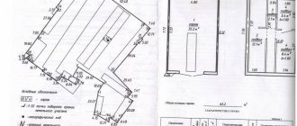
Section of unified land use of a land plot
After all the steps completed, all that remains is to fill out the “XML” tab for the electronic document (Fig. 9). We add the “XML” section; this section can be included in the boundary plan only in one copy. If it is not enabled, then uploading to an electronic document will not be performed. In this section, you must specify “!Type of information” - in our example, we will select “package of information with a statement of changes.” Check the box “Include digital signature files in the ZIP archive.”
Formation of unified land use
Today, clarification can be carried out in various ways. But the most popular option is special programs. With the help of such programs, you can create a detailed and competent boundary plan, which is necessary for clarification. Today there are a large number of programs. All programs have an intuitive interface and are very easy to use. To draw up a boundary plan, you need to fill out several XML documents (tables).
First you need to install the program. After this, you need to enter various data (cadastral number, number of plots, coordinates and much more). Next, a special program will create a detailed boundary plan. There is another way to create a boundary plan. To do this, you need to use a standard Excel spreadsheet. However, this method is less effective.
Various methods are used to carry out the EZ section. First of all, the characteristics and features of the site are taken into account. The concept of single land use is considered separately in each specific case. It is also necessary to pay attention to interaction with employees of the cadastral chamber.
Clarification of unified land use in the program “Polygon: Boundary Plan”
Let's return to the program “Polygon: Boundary Plan”
(Fig. 1). The program is controlled using the toolbar, and the current action that the program is performing and the result of its completion are displayed in the status line. The information panel displays a hint about the item from the Order corresponding to the field being filled in.
The initial data must be entered on the “Initial” tab (Fig. 2). We enter the documents on the basis of which the boundary plan was drawn up in table “1. List of documents used in drawing up the boundary plan.” The list of these documents can be copied to the “Contents” tab; to do this, place the cursor in the “Appendices” table and click on the “Calculate/Fill” button.