Architecture and urban planning are among the most ancient industrial sectors, where compliance with all legislative, technical, functional and operational standards and regulatory restrictions is mandatory.
Each nation today has its own traditions of the location and mutual localization of streets, squares and other elements of urban planning:
- In relatively new urban formations, this is generally a rectangular arrangement, where the streets are strictly perpendicular to each other and the intersections form clear right angles.
- No less often, especially in ancient cities located in warm climatic zones near trade land and waterways, a radial arrangement of streets occurs when they diverge in different directions from one center. It could be a palace, a temple, a square or a market, usually also located in the square.
It was during those times that many definitions appeared in the urban planning industry, which remain relevant today.
First of all, in addition to highly specialized terms, there are generally accepted ones that are used by literally all people, even those very far from the construction industry. This is a widely used term in completely different guises - the red line.
Despite the fact that the name is quite old, its essence has not changed at all over the course of several centuries. To know exactly the features of this term, it is necessary to consider it in theoretical and practical aspects.
What is a red line in construction?
The construction and development of the architectural industry involves a variety of interpretations of the names used and considers the concept of the red line as follows:
- As a certain designation of existing, planned, changed, newly formed boundaries of the territory for general use.
- In addition, the line can also be the boundary of a land plot on which power lines, communications, various linear cable structures and structures, and pipelines of various purposes are located.
- It limits the network of highways and highways, railway lines and other similar linear structures.
- It separates the public and public parts of the territories from the plots of land that are being developed by private individuals.
- In terms of documentation, the red line is approved as part of the territory planning project and is displayed on the drawing of the territory surveying project.
- General plans of the settlement, city district boundaries, zones with various functional purposes are legally defined in relation to the red lines, and the territorial zoning boundaries are established in relation to these lines.
Legislatively, this category of planning and construction was first reflected in 1998 by the Town Planning Code of the Russian Federation, and the expansion of the concept and the introduction of new features into it was made in a new edition of 2004 in paragraph 11 of Art. 1.
Today, there are several aspects of life and production activity when it is extremely important to know the features of dislocation, that is, how and where the red line runs.
Red building line
The concept of the red building line
When it comes to land ownership
...then, first of all, we mean the plot of land itself within these boundaries. Land may include areas that are owned by someone, such as private or municipal, and there are places with areas of public land.
Plots of public land also have their own owner, but are used by a large number of people. This becomes important when the owner of the plot wants to build a house on his territory.
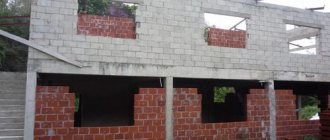
The house should be built on his land, not on the sidewalk. When building a house, the legislation provides for the concept of a red line; it is on this concept that the requirements for choosing a building site are based.
The municipal government of the locality sets the red line according to the normative act
Such a red line is needed to determine the boundary between the site where the house will be built and other areas that are used for public purposes.
What does the red line show?
Important! The red building line shows the territory of not a single plot of land for building a house on it, but shows the border of a whole block of similar plots. The territory is delineated in such a way that plots of land are located inside the enclosed territory, and behind this contour there is a public area.
Such a red building line is usually drawn when high-voltage transmission lines, pipelines, gas pipelines, heat pipelines and others pass through a plot of land. Construction is prohibited inside such areas.
These lines began to be called that because they are drawn in red on urban planning documents. When the authorities decide to draw such red lines, they take into account not only what currently stands, but also what can be built on this territory in the future.
Application of the red building line in practice
In what places a residential building or other outbuildings can be built is determined by various building codes, regulations, and on the basis of the Russian town planning code.
This means that you cannot build a house or other structure in absolutely any place inside one piece of land. Let's take a closer look at the legal requirements.
Previously, there were situations when citizens first built a house or other buildings on a piece of land, and only then went to local authorities to legalize it. And local authorities treated such situations quite leniently, even if the rules for applying the red line were violated.
Now the situation has changed, and if they are trying to legalize an already built house, then this can only be done by going to court. And a positive solution may not be in all cases. And the constructed structure may be considered illegally built, and in the future it will need to be demolished.
Therefore, it is important to choose the right sequence of actions. First you need to collect all the basic documents, which will indicate the location on which the house and outbuildings will be built.
With these documents you need to go to the local authorities to obtain permission. After this, you can begin building a house or building, since you will have documents in your hands in accordance with the requirements of the law.
Important! Legislative norms establish requirements for the distance between the red line and the place where development is planned.
Also, during construction, one should not forget about fire safety standards, according to which there is a strictly defined distance between houses on adjacent plots of land.
Violation of urban planning norms
If urban planning standards are violated during the construction of houses and outbuildings, various situations are possible.
Let's consider the cases that occur most often:
- – if the construction of a house or other building was carried out in violation of the required standards, then such development may be considered illegal if the building lines are violated;
- – also, if the neighbors prove that your construction of the house caused damage, that is, they were not able to fully use their own plot after this, then a lawsuit may begin, as a result of which some buildings may be declared illegal and subject to demolition, or by a court decision you must will pay the plaintiff monetary compensation for damage;
- – you also need to take into account the fact that even if the norms of the construction law are not violated, there may be inconsistency of buildings between neighboring areas. For example, an owner wants to build a bathhouse on his property in a certain place, and his neighbor will build a toilet on his property nearby. In this case, the rules of the law have not been violated, but when planning the construction of your house or bathhouse, you need to take into account the possibility of such inconvenient moments;
- – it is possible that when building a house on your own site in accordance with all the norms of the law, taking into account distance standards, the roof may be positioned in such a way that it will interfere with someone else’s site or snow will fall from it onto the neighboring site. This will be a violation and may result in a fine.
If building codes and regulations were violated, then responsibility for this will be administrative.
Urban planning standards for the red building line
During construction, all buildings and structures must be located inside the territory, which are indicated by red lines; there is also a requirement that they be located at some distance from the red lines.
A fence can be installed that shows the limitation of a private yard; it can run along the red line, but the building itself must be 5 meters away from it. This rule is valid when the situation concerns the line separating the site from the street. A street here can be either a roadway or the sidewalk itself.
There is a limitation related to the distance to the border of the site, which is not related to the red line. In this case, the minimum distance should be 3 meters.
If a building is being built, on the ground floor of which there will be premises for organizations of a public nature, for example it could be a store or a cafe, then in this case you can not deviate from the red line, but locate the building next to it.
The distance by which the building should retreat from the red line: not only the building itself, that is, its foundation, is taken into account, but its protruding parts are also important. For example, the distance to the red line will be calculated not from the wall of the house, but from the edge of the roof, which protrudes beyond the edges of the building. This point is very important and must be taken into account at the development planning stage.
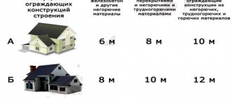
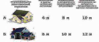
The above standards refer to the sanitary category. There are also requirements related to fire safety; here you need to pay attention to the material from which the building or house is constructed. According to the law, there is a certain standardized minimum distance between neighboring houses.
If the walls of the house are built of bricks, concrete, with stone floors, then the minimum distance can be 6 meters. If wooden houses are being built, or using wooden floors, then the minimum distance between houses should be increased to 15 meters.
Where can I find out about the location of the red lines?
To obtain reliable information about where the red building line should be, in order to take this into account during construction, you need to go to the cadastral chamber. There you will need to request the following documents, this is a situational plan, and a general plan.
If you do not want to request documents yourself, you can contact a cadastral specialist. The cadastral engineer will charge a certain amount of money for this, but will do his job and provide accurate information on your question, and will also link the location of the red line to the area.
When is it important to know the location of the red lines?
When planning an individual development, you need to take into account a lot of things that will fundamentally decide the success of your project.
In addition to choosing a general architectural solution, a suitable design, orientation of the future building relative to the cardinal directions, an assortment of building and finishing materials, construction on the site of small architectural forms corresponding to the general concept and other nuances, you should pay attention to one very significant nuance.
This is the location of the future object relative to the red line, which is especially important for the following reasons:
- Construction work must be carried out in relation to the plot boundaries plan.
- When starting preliminary design, you should immediately calculate the plans of buildings or structures in such a way that the red line does not cross.
- In accordance with established standards, the plan of the future building must be located at some distance from the zone designated by the line.
In order to avoid problematic situations in the future, designers, developers and everyone who will take part in the construction or reconstruction of buildings and other objects need to approach these issues very carefully and extremely seriously.
"Letters of happiness"
Several residents of Yaroslavsky Passage on Gora received subpoenas from the administration of the Central District.
They want to force people to demolish fences, buildings and even parts of houses that extend beyond the red lines. Otherwise, they threaten to impose thousands of fines. The reason for the inspection and the district administration's appeal to the court was a complaint from one of the residents of this street. The first court hearings have already begun, and examinations have been ordered on the cases.
But Barnaul resident Andrei Larin from Tretyakov Street has already received a fine for “seizing public territory” - as he claims, without trial or warning. The man bought a house and did not change the boundaries of the land plot. That is, he may have inherited the mistakes of the previous owner. Now Larin has to find out who is right - he or the administration.
Tretyakov Street in Barnaul.
Andrey Larin for altapress.ru
What is the red line
According to the Town Planning Code of the Russian Federation, red lines are lines that indicate existing, planned, changed and newly formed boundaries of public areas and territories occupied by linear objects (bridges, roads, power lines, pipelines, etc.) and intended for their location .
How do “red lines” affect the fate of a land plot?
Compliance with the rules for localizing capital construction projects significantly influences how the further exploitation of land plots will develop.
Indicators regarding the development of the residential sector, public and business areas are determined by a document that regulates all distances and their ratio.
This is SNiP RK 3.01-01-2008 “Urban Planning”.
The document indicates that the property is not supposed to cross the border marked by the red line.
If this happens, then the building may be partially or completely located in a public area.
Which in turn very seriously affects the possibilities of further land privatization. Clause 12 of Art. 85 of the Land Code of the Russian Federation, a plot of land that is in social use is not subject to the privatization process.
The consequence is the following:
- It is impossible to privatize the land on which the real estate you own is located . Crossing the red line completely and categorically negates the possibility of ownership, even in court.
- The only solution is to rent land, but this complicates possible manipulations with the house - providing it as collateral.
The need to take into account the location of “red lines” during construction
Why is it so important to take into account the location of the red line grid and its location on the terrain if the proposed construction will be carried out in areas remote from the city?
After all, most of the plots of land that are offered for individual development these days are located at a great distance from city streets and may at first glance seem completely unimproved.
The need for construction planning is as follows:
- It is unacceptable to locate buildings within the red line.
- Control is carried out by the norms of permitting documents for development, which clearly define the scheme and plan for working with the land plot.
- At the same time, the scheme regulates the boundaries of the site, its relationship to the red line and the actual location of the proposed object.
Distance from the red line to the building line
When a person has a desire to build his own house, he first of all thinks about creating its design and location on a specific plot of land. But the development of the site cannot occur arbitrarily.
It is necessary to comply with the norms established by law for the placement of buildings, buildings and structures on a specific site.
In accordance with the accepted standards for planning and development of areas of low-rise construction and dacha associations, it is customary to use the following standards that relate to distances between various objects:
- the gap between the red line of streets* and a residential building cannot be less than five meters;
- the gap between the red line of passages** and residential buildings must be more than three meters;
- there should be no less than five meters between the red lines of streets and driveways and outbuildings;
- between a residential building and the boundary of a neighboring plot of land*** - at least three meters;
- the distance between outbuildings intended to house livestock and the boundary of the neighboring plot is at least 4 meters;
- other outbuildings (baths, garages) and the boundaries of the area in the neighborhood should not be at a distance of less than 1 meter;
- the distance between the planting site of tall trees with a dense crown and the border of the neighboring plot should not be less than 4 meters;
- the distance between the place where low-growing trees are planted and the border of the neighboring plot should be within 2 meters;
- the distance between the bushes and the boundary of the neighboring plot cannot be less than 1 meter.
* - a street is an area that is in common use by citizens; vehicles and pedestrians move along it. It includes two lanes of the roadway, a shoulder, ditches, etc.;
** - passage is an area that is used for the movement of pedestrians and vehicles and includes one lane of the roadway, roadside, etc.;
*** - the distance between a residential building or other buildings and the boundary of the neighboring plot is measured from the base of the building or from its wall. This gap is taken into account only if the porch, canopy or other elements of the house do not protrude beyond the plane of the wall by more than half a meter. Otherwise, the distance will be measured from that part of the house that protrudes beyond the general plane.
Additional restrictions when planning and developing gardening areas include:
- if the roof of an outbuilding has a slope that is located at a distance of 1 meter from the neighboring plot, it is necessary to reorient the slope so that rainwater does not drain onto the neighbors’ plot;
- the distance from the house to the bathhouse, outdoor shower or toilet cannot be less than 8 meters. The compost pit should not be closer to the house than 8 meters;
- if other buildings are adjacent to a residential building, then when determining the distance to the neighboring plot, data on the proximity of each combined building separately is used. For example, if a house and a garage are combined, then the distance from the house to the neighboring plot should be at least 3 meters, and from the garage - at least 1 meter. If a barn for animals is adjacent to the house, then the distance from them can be at least 3 meters from the house and 4 meters from the barn.
If the red line crosses a building
This situation is possible when planning the reconstruction or expansion of streets or roadways in old areas of large cities.
At the time of commissioning, which could have been from fifty to twenty years ago, the red line was located within slightly different limits.
Therefore, renovation and other work lead to the fact that the new line may well cross one or another building or structure.
The document stipulated the inadmissibility of infringing on the right of the building owner to acquire his property under these conditions. In the vast majority of cases, the courts are on the side of the owner of the capital facility.