Sometimes landowners need to carry out redistribution and establish new boundary points of their territories. During the procedure, an increase in the size of the property or the formation of several plots from one may occur.
The results of this event must be documented in full compliance with current laws, and changes are made to the site survey plan.
What is land redistribution
One of the options for obtaining new territories is land redistribution. All requirements for this procedure, as well as the procedure for conducting the event, are clearly stated in the Land Code of the Russian Federation. This information is contained in Article 117. However, it is worth considering that this method can only be used by owners of landholdings adjacent to each other.
The result of the redistribution measure is the formation of adjacent land plots with other boundary points. Old landholdings, in fact, cease to exist.
If title to the property has been registered, it will automatically be transferred to the property created during the procedure.
Territories owned by state or municipal authorities can be redistributed in accordance with the rules established by housing legislation.
What is it and what are the requirements
Redistribution of a land plot is the introduction of adjustments, the result of which is the annexation of any other plots to a certain territory for the implementation of a specific goal. The most common methods for carrying out this procedure are the annexation of land that is owned by municipal authorities, as well as the acquisition of a certain part of an adjacent plot from its owner.
The most common basis for redistribution today is the allocation of a land plot from state or municipal property in order to transfer it to various citizens for individual residential construction, private farming, and agricultural activities.
In this case, an extension means the expansion of the existing boundaries of a territory by annexing land plots that have been used for a certain period of time without the presence of certain documents. Accordingly, such land plots were subject to unauthorized seizure, and the owners of such plots are government agencies.
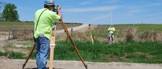
Do not forget that any measurements in the specified area are carried out exclusively by authorized cadastral engineers, while redistribution is carried out by a company specializing in geodetic activities and having the appropriate license.
Sample of notarized consent
When is it necessary to redistribute land plots?
The need for land redistribution arises under certain circumstances:
- When carrying out communication systems across the territory of adjacent property;
- In order to maintain the minimum distance established by law between the boundaries and the structure erected on the site;
- If during the trial it was decided to move the boundary points;
- If you need to divide the territory between several owners;
- To increase the size of land ownership due to the area of the neighboring one;
- To get rid of stripes or correct geometrically irregular borders;
- When planning the construction of a building on the border of land ownership.
In the case where necessary communications, such as water supply or power lines, need to be carried out through the territory of adjacent land ownership, it is best to use the right to redistribution and buy out the part of the land necessary for the work from the owner of the land located next door.
Regulatory legal acts contain a provision establishing the minimum distance between the constructed residential premises and the boundary points of land ownership. If this instruction is not followed, and construction has already begun, you need to think about the possibility of moving the boundaries.
Redistribution can also be applied in the case where the land must be divided between heirs, each of whom has left his own plans for its use and does not intend to give up the part due to him. The distribution of shares of a peasant farm is also preceded by a procedure for changing boundaries: only after this can participants receive the land plot due to them from the common ownership.
If it is quite difficult to use land ownership for certain purposes, due to its irregular shape (broken boundaries or sharp corners), or located strips of land belonging to another owner (interstriped), then redistribution will also come to the rescue, allowing the establishment of smoother boundaries of ownership.
How to change the size or boundaries of land plots.
Dividing a plot of land into several plots.
During division, several land plots are formed, and the original land plot (the one from which land plots are formed during division ceases to exist).
This procedure, as a rule, is applied if the owner has a need to dispose of (rent, sell) part of the land plot, or in the case of division by agreement of the parties of a plot that is in common ownership.
To carry out the division procedure, we prepare the appropriate decision of the owner/owners, and also carry out subsequent registration/removal from cadastral registration and registration of rights to several plots.
Allocation of land. Why is land allocation necessary?
When a land plot is allocated, one or more new land plots are formed, however, the land plot from which the allocation was made remains within the changed boundaries. Land allocation is most often used when dividing shared property.
For example, a participant in shared ownership, upon whose application the allocation is carried out, acquires the right to the newly formed plot and loses the right of shared ownership to the plot from which the share is allocated. In most cases, this procedure is used when allocating land shares in kind.
Consolidation of land plots. In what cases does merging plots make sense?
The merger procedure involves the formation of one land plot from several adjacent ones. If plots belonging to different persons are combined, they have the right of shared ownership of the newly formed plot.
Consolidation makes sense if the owner acquires an adjacent plot of land for the purpose of construction on the merged plot of land. By definition, a capital construction project cannot be located on different land plots, even if they belong to the same person.
Redistribution of land plots. Increasing the area of your land plot.
Redistribution at its core is the annexation of an adjacent land plot and the subsequent change of boundaries, as a result of which a new plot is formed, and the original plots cease to exist. Moreover, if the redistribution of plots belonging to several persons is carried out, by agreement among themselves they must determine the legal status of the newly formed plots .
The goals in this case can also be very diverse, from commercial (combining large plots owned by a person and forming smaller plots from them for further sale or development) to a regular agreement between neighbors, according to which they slightly change the boundaries of adjacent plots belonging to them.
Using the land redistribution procedure, you can significantly increase the size of your land plot at the expense of adjacent free land in the zone of individual residential development, private farming, gardening or dacha farming.
Requirements for redistribution of land plots
Land redistribution can only be done between adjacent landholdings. Before doing this, it is imperative to make sure that the land is not seized and no sanctions are imposed on it.
In addition, other requirements are put forward for the territories:
- Mandatory registration in the cadastral register;
- It is located on the territory of the same administrative district - it is prohibited to violate the boundaries of these entities even during redistribution;
- They have the same categories of target land use.
In fact, redistribution is used quite rarely. Basically, it is required in cases where the owners are not satisfied with the state of the boundaries (for example, the presence of sharp corners that impede the planned use of the land). If an agreement is reached, land redistribution can be carried out without unnecessary delays.
This problem can be solved in another way. There is always the option of consolidating land holdings and their subsequent division into plots that will fully satisfy their owners in size and shape. But carrying out this event will require considerable financial and time expenditures, which not everyone can afford. Redistribution is a shorter event that does not require financial influences.
But sometimes redistribution is not possible. This procedure is prohibited if during its implementation the current law of the Russian Federation or any of its clauses is violated.
Such cases include the formation of plots with an increase or decrease in their area, as well as blocking access of properties to the road in the course of changes in ownership, overlapping of lands. Prohibited actions also include the redistribution of land owned by the state or municipality, both with each other and with private territories, unless this procedure is required to make corrections to the cadastre plan, which are required, for example, by development.
In some cases, the implementation of such actions requires the permission of certain citizens: tenants, owners, land users and lien holders.
Addition of land in 2020
- in the search bar of Yandex and/or Google, type the number of the cadastral quarter in which your land plot is located,
- on the website of the local administration (if you want to add municipal land to the site) or on the website of the regional government (if you plan to add state land to the site), look for regulatory documents (decrees) on the approval of land surveying projects,
- send a written request to the administration asking the question: has the land surveying project been approved for the cadastral quarter in which your land plot is located.
This is all done, the agreement is concluded. Only initially, when we approached the issue of redistribution, the goal was to expand the site to allow for more rational construction, but they explained to us that you can’t only go as far as the border, otherwise we will refuse you. Having completed the redistribution, it became clear from the procedure that if we had applied to expand the width, the procedure would have proceeded similarly. Therefore, they applied again, to which they received a refusal that the scheme intersects with the already approved one according to which the site was formed. Although, once we begin to understand, the question arises: the scheme as such is needed to form the site, and once the site is formed, is the previously approved scheme valid?
We recommend reading: Low-Income Family 2020 Benefits Republic of Bashkortostan
How to formalize an agreement on the redistribution of land plots
To perform a redistribution, follow these steps:
- Think about whether there is any hope of getting the desired result. Before entering into an agreement, site owners should carefully review all paperwork for the property that will be involved in the planned procedure. It is better to make a request to the state cadastre authorities, where you can obtain all the important information. The procedure can only be started if the territories are adjacent to each other and are located in the same administrative district;
- Draw up an agreement between the parties. Since several parties take part in a transaction, the entire procedure must begin with the conclusion of an agreement. In its absence, the procedure becomes judicial. The legislation does not indicate how many participants can be involved in redistribution.
When concluding a contract, it must stipulate:
- Information about land owners - full name, passport information, actual residence address;
- Correct data on the land holdings in respect of which the redistribution is being carried out (size of the territory, number of the plot in the cadastre register, location address, type of permitted use, date when the ownership and place of registration was issued, details of the paper confirming the right of ownership);
- Information is indicated about each landholding participating in the procedure;
- Calculate the possible benefits and identify the risks. If, following redistribution, the owner of one of the plots receives a smaller territory at his disposal, then he has the right to claim compensation for the value of the lost land. The compensation amount must be specified in a separate clause in the agreements, which is best discussed in advance.
Sample agreement on redistribution of land plots
Owners of adjacent land plots who want to change the boundary points enter into an appropriate agreement and formalize it in simple written form.
It states:
- Information about persons having ownership rights;
- Information about sites classified as technical;
- An indication of the rights of the persons who conceived the redistribution to the zones participating in it;
- Purpose of the procedure.
The completed paper is sent to the cadastral engineer responsible for the geodetic survey. It is also necessary for submitting a request to government authorities and is used to formalize the resulting redistribution of properties, as well as documentation for them, for example, a cadastre passport.
Redistribution of land plots from January 1, 2020.
To clarify the location of the boundaries of a land plot registered in the cadastral register, read here.
For documents for land surveying, see the link:
When is such a procedure necessary?
The need for redistribution of land plots may arise due to a variety of life circumstances. For example, the existing layout of adjacent plots does not suit one of the owners, which can complicate the relationship between neighbors.
This situation is usually resolved by merging and further “cutting” the condemned areas, since it will be convenient for both parties, it is best for them to confirm the appropriate agreement in this regard.
The process of redistributing plots makes it possible to save time and avoid additional financial costs.
Attention: the redistribution procedure is not possible if the formation of new land plots somehow violates the requirements established by law for the formed land plots. There are no other restrictions regarding this issue.
The procedure for redistribution of land plots
To carry out this procedure, a certain procedure is provided for, fixed in regulatory legal acts.
Redistribution is carried out in several stages:
- Land owners draw up a written agreement that includes all the information needed for the upcoming event. Document collection is also carried out;
- A petition is written, which is subsequently sent to the Rosreestr department and to the organization that will carry out land management work;
- State body the authority having the appropriate powers makes a decision on the issue that arises regarding the redistribution of land;
- The cadastral engineer carries out all the necessary work on land surveying: he carries out a geodetic survey and draws up the results in the form of a land survey document that is consistent with the general cadastre plan;
- The plots received during the redistribution undergo the registration procedure in Rosreestr. This means that the created holdings are assigned their own cadastre number, the areas are entered into the State Land Register, a protocol is drawn up indicating the fact of the formation of new land holdings, and their owners are issued a cadastral passport;
- The last step is to register plots of land as the property of each of the citizens taking part in this procedure.
Property owners, employees of geodetic organizations and officials working in Rosreestr take part in various stages of redistribution. This procedure, like other similar events for the formation of new possessions, takes some time - approximately 2 months.
Application for redistribution of land plots
The petition is a document that serves as the basis for the planned procedure. It is filled out according to the appropriate template, which can be obtained from the authorities.
The application contains the following information:
- The name of the authority authorized to make decisions on these issues, where the petition and the papers attached to it are submitted;
- Information about the citizen who submitted the request and the grounds that give him the right to make decisions regarding the holding of the planned event - about ownership;
- Information about land ownership participating in the redistribution;
- The reasons for which the need for redistribution arose. If necessary, you must also provide a transcript of the reasons;
- List of papers submitted along with the petition (cadastral registration documents, certificates on the basis of which the owner has ownership rights, papers that will help verify the need for such a procedure);
- Signature of the person who left the petition and the date it was written. If the document is submitted by an authorized representative of the owner, then he is obliged to provide data from the document confirming his authority in resolving similar issues that the owner has vested in him.
Documents for redistribution of land plots
To begin the planned redistribution, collect a set of papers:
- Passports of land owners;
- Agreement concluded by the participants of the planned event;
- A petition to the Rosreestr authorities indicating the need for redistribution;
- Technical plan documents for everyone involved in the redistribution of ownership;
- Certificates confirming the establishment of ownership;
- At the request of the Cadastral Chamber employees, other papers may be included in the list.
Cost of land redistribution
To have an idea of the full cost of the procedure, it is necessary to take into account that it consists of a number of components:
- The cost of lands that will be annexed. The amount of money that will need to be contributed depends on the direct owner of the site - it can be either the state or a private person. In the latter case, the market price of the plot will be taken as a basis, and when federal land is annexed, the amount of the contribution will be calculated based on the value stated in the cadastre;
- Payment for the work of an employee of a geodetic company and the cost of surveying newly formed lands. You will have to pay approximately 15-50 thousand rubles - the amount of money directly depends on the constituent entity of the Russian Federation where the redistributed territories are located;
- State duty, which is charged both for the deregistration of land (2 thousand rubles) and for the registration of new land holdings (2 thousand rubles for the owner-citizen and 22 thousand for the organization).
What to do after receiving a land redistribution scheme
After forming a new land tenure plan and registering all changes with the cadastre authorities, register the resulting plot as a property. This procedure is carried out by Rosreestr, which accepts relevant applications from citizens carrying out land redistribution. Attached to the application are documents that reflect the changes made, as well as papers certifying the existence of ownership rights to the land, an agreement between the participants in the redistribution procedure and the conclusion of the official conducting land management work.
The purpose of redistribution is to form a possession convenient for use, and sometimes this requires the annexation of adjacent territories.
But all the requirements for the procedure are clearly defined by the laws of the Russian Federation, and the possibility of a refusal to implement it is extremely small. However, if you still receive an unsatisfactory response, eliminate the violations that served as the basis for the refusal and submit your application again.
The procedure for registering the territory
The procedure for registering land plots is as follows:
- The owners of the territory draw up a contract for redistribution, after which they prepare the required package of documents.
- An application is drawn up and then submitted to Rosreestr and the survey company. Application for land surveying work
- The authorized body issues a resolution on the basis of which the redistribution procedure is carried out.
- The cadastral engineer carries out all necessary boundary work.
- New plots are registered with Rosreestr, that is, the territories are assigned an individual number, a passport is issued, and data on the areas is entered into the cadastre.
- Ownership rights to the resulting plots are registered for each owner.
Refusal to redistribute land plots
Typically, redistribution may be refused for the following reasons:
- The owner of one of the plots did not give his permission to the procedure;
- The municipality or state have their own plans for the lands that are planned to be used for redistribution;
- There are buildings on the territory that are owned by municipal or state authorities;
- Land circulation is limited in this location;
- Lands are subject to transfer to an individual or legal entity who has a priority right to receive them and has used it;
- When the territory is annexed, the area of the site will exceed the maximum permitted.
The owner of the plot for which redistribution is planned can draw up a corresponding petition only if the violations that led to the refusal have been eliminated.
Changes in the redistribution procedure
At the beginning of July 2020, the procedure in question underwent changes, the latter due to the entry into force of Federal Law 334.
The changes affected government bodies dealing with issues of redistribution and registration of permits. The amendments address issues related to areas of undemarcated state property.
The content of the changes is the following:
- rural land issues are within the competence of local authorities;
- regarding clarification of the boundaries of land plots, you should also contact local administrations and administrations of rural settlements in whose territories they are located;
- upon completion of all redistribution procedures, their new owner or user receives title documents.
Along with these innovations, there are also a number of changes introduced to the Land Code relatively recently.
First of all, they address the issues of annexing parts or sections of municipal land to private property. Such lands are called subdivisions. The legislator allows such measures to be taken to annex municipal lands to private ones.
In fact, such a change in legislation gave grounds to legitimize the squatting of municipal plots by private owners. In addition, such a procedure may be necessary in a number of other cases.
How can I find out the boundaries of a plot using the cadastral number?
How to obtain permission to build a house on your own site, read here.
Public form of ownership of a land plot - what is it, read the link: